
FCCInfo.com
A Service of Cavell, Mertz & Associates, Inc.
(855) FCC-INFO
|
|
K245CL from 11/01/2013 |
|
|
||||||||||||||||
|
|
K245CL Channel: 245D 96.9 MHz Lancaster, California Service: FX - A translator or application for a translator. Facility ID: 143699 Fac. Service: FX Programming Delivery Method: Unspecified Status: License Application Accepted: 02/21/2017 Application Granted: 03/03/2017 File Number: BLFT-20170221ABV License Expires: 00/00/0000 Prefix Type: This is a license for a translator Application Type: License To Cover FCC Website Links: LMS Facility Details This Application CDBS Application Other K245CL Applications Other K245CL Applications in CDBS Including Superseded Applications Mailing Address Correspondence for K245CL Correspondence related to application BLFT-20170221ABV Service Contour - Open Street Map or USGS Map (60 dBu) Service Contour - KML / Google Earth (60 dBu) Class: D, A Noncommercial educational operating with no more than 10W Site Location: 34-44-40.9 N 118-07-33.3 W (NAD 83) Site Location: 34-44-41.0 N 118-07-30.0 W (Converted to NAD 27) Effective Radiated Power: 0 kW Horiz. ; 0.25 kW Vert. Transmitter Output Power: 0.067 kW Antenna Center HAAT: 0 m Antenna Center AMSL: 0 m Horiz.; 741 m Vert. Antenna Center HAG: 0 m Horiz.; 35 m Vert. Site Elevation: 706 m. (2316 ft.) Height Overall*: 124 m (407 ft.) (* As Filed In This Application, may differ from ASR Data, Below.) Directional Antenna Antenna Make/Model: None Antenna ID: 126751 Polarization:
| ||||||||||||||||||
| Antenna Data for Antenna Id: 126751 K245CL FX File: BLFT-20170221ABV None - Service: FX Pattern and Field Values Include a 180° Clockwise Rotation | 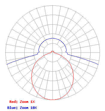 | ||||||||||||||||||
| Azimuth | Ratio | Azimuth | Ratio | Azimuth | Ratio | Azimuth | Ratio | ||||||||||||
| 0 | 0.030 | 10 | 0.030 | 20 | 0.030 | 30 | 0.030 | ||||||||||||
| 40 | 0.030 | 50 | 0.030 | 60 | 0.030 | 70 | 0.030 | ||||||||||||
| 80 | 0.030 | 90 | 0.030 | 100 | 0.050 | 110 | 0.190 | ||||||||||||
| 120 | 0.390 | 130 | 0.544 | 140 | 0.690 | 150 | 0.817 | ||||||||||||
| 160 | 0.916 | 170 | 0.980 | 180 | 1.000 | 190 | 0.980 | ||||||||||||
| 200 | 0.916 | 210 | 0.817 | 220 | 0.690 | 230 | 0.544 | ||||||||||||
| 240 | 0.390 | 250 | 0.190 | 260 | 0.050 | 270 | 0.030 | ||||||||||||
| 280 | 0.030 | 290 | 0.030 | 300 | 0.030 | 310 | 0.030 | ||||||||||||
| 320 | 0.030 | 330 | 0.030 | 340 | 0.030 | 350 | 0.030 | ||||||||||||
Structure Registration Number 1027510 [ASR Heights Differ from K245CL Application] Structure Type: GTOWER Registered To: HIGH DESERT BROADCASTING LLC Structure Address: 264 E Ave F Lancaster, CA County Name: Los Angeles County ASR Issued: 02/14/2023 Date Built: 01/01/1969 Site Elevation: 705.9 m (2316 ft.) Structure Height: 122 m (400 ft.) Height Overall: 123.5 m (405 ft.) Overall Height AMSL: 829.4 m (2721 ft.) FAA Determination: 11/26/2021 FAA Study #: 2020-AWP-2588-OE FAA Circular #: 70/7460-1M Paint & Light FAA Chapters: 3, 4, 5, 15 PRIOR STUDY 2017-AWP-278-OE 34-44-41.6 N 118-07-33.3 W (NAD 83) 34-44-41.7 N 118-07-30.0 W (Converted to NAD 27) |
715 Broadway Suite 320 Santa Monica, CA 90401 Phone: 310-451-4430 Limited Liability Company | Date: 02/21/2017 Application Certifier GOLD COAST BROADCASTING LLC 715 Broadway Suite 320 Santa Monica, CA 90401 Applicant DARRYL K DELAWDER Delawder Communications, Inc. P.o. Box 1095 Ashburn, VA 20146-1095 CONSULTING ENGINEER DAVID OXENFORD Wilkinson Barker Knauer Llp 1800 M Street, N.w. Suite 800n Washington, DC 20036 | |||||||||||||||||