
FCCInfo.com
A Service of Cavell, Mertz & Associates, Inc.
(855) FCC-INFO
|
|
|
|
|
||||||||||||||||
|
|
KSRD Channel: 220C3 91.9 MHz St. Joseph, Missouri Service: FM - A full-service FM station or application. Facility ID: 85873 Fac. Service: FM Status: License Application Accepted: 09/28/2004 Application Granted: 10/06/2004 File Number: BLED-20040928AHD License Expires: 00/00/0000 Prefix Type: This is a license for a noncommercial educational FM station Application Type: License To Cover FCC Website Links: LMS Facility Details This Application CDBS Application Other KSRD Applications Other KSRD Applications in CDBS Including Superseded Applications Mailing Address Correspondence for KSRD Correspondence related to application BLED-20040928AHD Service Contour - Open Street Map or USGS Map (60 dBu) Service Contour - KML / Google Earth (60 dBu) Public Inspection Files Facility Type: NON-COMMERCIAL EDUC. FM Class: C3, A Zone II station; with 6kW-25kW ERP and a class contour distance 28km-39km Site Location: 39-42-35.0 N 95-02-33.9 W (NAD 83) Site Location: 39-42-35.0 N 95-02-33.0 W (Converted to NAD 27) Effective Radiated Power: 10 kW Transmitter Output Power: 3.2 kW Antenna Center HAAT: 150 m (492 ft.) Antenna Center AMSL: 435 m (1427 ft.) Antenna Center HAG: 123 m (404 ft.) Site Elevation: 312 m. (1024 ft.) Height Overall*: 291 m (955 ft.) (* As Filed In This Application, may differ from ASR Data, Below.) Directional Antenna Antenna Make/Model: Electronics Research Inc. LPX-4E-DA Antenna ID: 15189 Polarization:
| ||||||||||||||||||
| Antenna Data for Antenna Id: 15189 KSRD FM File: BLED-20040928AHD Electronics Research Inc. - LPX-4E-DA Service: FM | 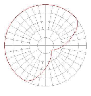 | ||||||||||||||||||
| Azimuth | Ratio | Azimuth | Ratio | Azimuth | Ratio | Azimuth | Ratio | ||||||||||||
| 0 | 1.000 | 10 | 1.000 | 20 | 1.000 | 30 | 1.000 | ||||||||||||
| 40 | 1.000 | 50 | 1.000 | 60 | 0.891 | 70 | 0.708 | ||||||||||||
| 80 | 0.562 | 90 | 0.447 | 100 | 0.355 | 110 | 0.282 | ||||||||||||
| 120 | 0.224 | 130 | 0.178 | 140 | 0.224 | 150 | 0.282 | ||||||||||||
| 160 | 0.355 | 170 | 0.447 | 180 | 0.562 | 190 | 0.708 | ||||||||||||
| 200 | 0.891 | 210 | 1.000 | 220 | 1.000 | 230 | 1.000 | ||||||||||||
| 240 | 1.000 | 250 | 1.000 | 260 | 1.000 | 270 | 1.000 | ||||||||||||
| 280 | 1.000 | 290 | 1.000 | 300 | 1.000 | 310 | 1.000 | ||||||||||||
| 320 | 1.000 | 330 | 1.000 | 340 | 1.000 | 350 | 1.000 | ||||||||||||
Structure Registration Number 1206810 Structure Type: TOWER Registered To: Eagle Communications, Inc. Structure Address: 6 Statute Miles Southeast Of Troy, Kansas Troy, KS County Name: Doniphan County ASR Issued: 04/27/2004 Date Built: 04/24/2000 Site Elevation: 312 m (1024 ft.) Structure Height: 290 m (951 ft.) Height Overall: 291.1 m (955 ft.) Overall Height AMSL: 603.1 m (1979 ft.) FAA Determination: 06/08/2000 FAA Study #: 00-ACE-0859-OE FAA Circular #: 70/7460-1J Paint & Light FAA Chapters: 3, 4, 5, 13 Removed embedded carriage return(s) and extraneous quotation marks./jjs/case#1764417 39-42-34.6 N 95-02-33.5 W (NAD 83) 39-42-34.6 N 95-02-32.6 W (Converted to NAD 27) |
5700 West Oaks Blvd Rocklin, CA 95765 Phone: 916-251-1600 Not-for-Profit | Date: 09/28/2004 Application Certifier HORIZON CHRISTIAN FELLOWSHIP 5331 Mount Alifan Dr San Diego, CA 92111-2622 Applicant ROBERT H BRANCH JR 212 Honey Tree Lane Lynchburg, VA 24502 TECHNICAL CONSULTANT KAREN WOODS Horizon Christian Fellowship | |||||||||||||||||