
FCCInfo.com
A Service of Cavell, Mertz & Associates, Inc.
(855) FCC-INFO
|
|
KLBT from 04/17/1997 |
|
|
||||||||||||||||
|
|
KLBT Channel: 201C2 88.1 MHz Beaumont, Texas Service: FM - A full-service FM station or application. Facility ID: 86329 Fac. Service: FM Status: License Application Accepted: 05/11/2016 Application Granted: 05/16/2016 File Number: BLED-20160511ABH License Expires: 00/00/0000 Prefix Type: This is a license for a noncommercial educational FM station Application Type: License To Cover FCC Website Links: LMS Facility Details This Application CDBS Application Other KLBT Applications Other KLBT Applications in CDBS Including Superseded Applications Mailing Address Correspondence for KLBT Correspondence related to application BLED-20160511ABH Service Contour - Open Street Map or USGS Map (60 dBu) Service Contour - KML / Google Earth (60 dBu) Public Inspection Files Facility Type: NON-COMMERCIAL EDUC. FM Class: C2, A Zone II station; with 25kW-50kW ERP and a class contour distance 39km-52km Site Location: 29-54-52.8 N 94-17-06.7 W (NAD 83) Site Location: 29-54-52.0 N 94-17-06.0 W (Converted to NAD 27) Effective Radiated Power: 30 kW Horiz. ; 28.5 kW Vert. Transmitter Output Power: 4.65 kW Antenna Center HAAT: 145 m (476 ft.) Antenna Center AMSL: 147.5 m (484 ft.) Antenna Center HAG: 142 m (466 ft.) Calculated Site Elevation: 5.5 m. (18 ft.) Height Overall*: 152.1 m (499 ft.) (* As Filed In This Application, may differ from ASR Data, Below.) Directional Antenna Antenna Make/Model: Shivley 6815-7-DA, SEVEN SECTIONS Antenna ID: 113037 Polarization: | ||||||||||||||||||
| Antenna Data for Antenna Id: 113037 KLBT FM File: BLED-20160511ABH Shivley - 6815-7-DA, SEVEN SECTIONS Service: FM | 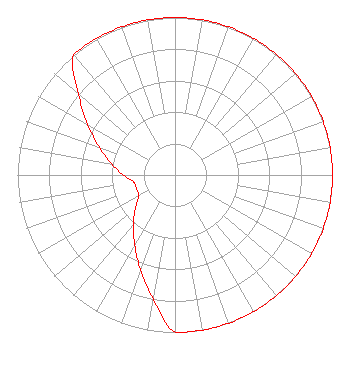 | ||||||||||||||||||
| Azimuth | Ratio | Azimuth | Ratio | Azimuth | Ratio | Azimuth | Ratio | ||||||||||||
| 0 | 1.000 | 10 | 1.000 | 20 | 1.000 | 30 | 1.000 | ||||||||||||
| 40 | 1.000 | 50 | 1.000 | 60 | 1.000 | 70 | 1.000 | ||||||||||||
| 80 | 1.000 | 90 | 1.000 | 100 | 1.000 | 110 | 1.000 | ||||||||||||
| 120 | 1.000 | 130 | 1.000 | 140 | 1.000 | 150 | 1.000 | ||||||||||||
| 160 | 1.000 | 170 | 1.000 | 180 | 1.000 | 190 | 0.800 | ||||||||||||
| 200 | 0.640 | 210 | 0.512 | 220 | 0.410 | 230 | 0.328 | ||||||||||||
| 240 | 0.265 | 250 | 0.260 | 260 | 0.265 | 270 | 0.328 | ||||||||||||
| 280 | 0.410 | 290 | 0.512 | 300 | 0.640 | 310 | 0.800 | ||||||||||||
| 320 | 1.000 | 330 | 1.000 | 340 | 1.000 | 350 | 1.000 | ||||||||||||
Structure Registration Number 1249922 Structure Type: TOWER Registered To: The King's Musician Educational Foundation, Inc. Structure Address: 2.25 Miles Southwest Of City, Along I-30 Near Roadside Park Fannett, TX County Name: Jefferson County ASR Issued: 08/30/2005 Date Built: 07/06/2006 Site Elevation: 5.5 m (18 ft.) Structure Height: 151.2 m (496 ft.) Height Overall: 152.1 m (499 ft.) Overall Height AMSL: 157.6 m (517 ft.) FAA Determination: 08/26/2005 FAA Study #: 2005-ASW-4614-OE FAA Circular #: 70/7460-1K Paint & Light FAA Chapters: 4, 8, 12 Removed expiration date from determination. Scenario 1./jjs/case#635066 29-54-52.6 N 94-17-07.0 W (NAD 83) 29-54-51.8 N 94-17-06.3 W (Converted to NAD 27) |
975 Interstate 10 North Beaumont, LA 77706 Phone: 409-673-7986 Not-for-Profit | Date: 05/11/2016 Application Certifier THE KING'S MUSICIAN EDUCATIONAL FOUNDATION, INC. 1872 Calder Beaumont, TX 77701 Applicant JOHN J. MULLANEY Mullaney Engineering, Inc. 4937-g Green Valley Road Monrovia, MD 21770 CONSULTING ENGINEER JOSEPH C. CHAUTIN, III Hardy, Carey, Chautin & Balkin, L.l.p. | |||||||||||||||||