
FCCInfo.com
A Service of Cavell, Mertz & Associates, Inc.
(855) FCC-INFO
|
|
|
|
|
||||||||||||||||
|
|
W221BS Channel: 221D 92.1 MHz St. Paul, Minnesota Service: FX - A translator or application for a translator. Facility ID: 142091 Fac. Service: FX Programming Delivery Method: Unspecified Status: License Application Accepted: 02/02/2017 Application Granted: 02/28/2017 File Number: BLFT-20170202ABF License Expires: 00/00/0000 Prefix Type: This is a license for a translator Application Type: License To Cover FCC Website Links: LMS Facility Details This Application CDBS Application Other W221BS Applications Other W221BS Applications in CDBS Including Superseded Applications Mailing Address Correspondence for W221BS Correspondence related to application BLFT-20170202ABF Service Contour - Open Street Map or USGS Map (60 dBu) Service Contour - KML / Google Earth (60 dBu) Class: D, A Noncommercial educational operating with no more than 10W Site Location: 44-56-53.9 N 93-05-44.8 W (NAD 83) Site Location: 44-56-54.0 N 93-05-44.0 W (Converted to NAD 27) Effective Radiated Power: 0.08 kW Transmitter Output Power: 0.203 kW Antenna Center HAAT: 0 m Antenna Center AMSL: 380 m (1247 ft.) Antenna Center HAG: 145 m (476 ft.) Site Elevation: 235 m. (771 ft.) Height Overall*: 154 m (505 ft.) (* As Filed In This Application, may differ from ASR Data, Below.) Directional Antenna Antenna Make/Model: None Antenna ID: 126599 Polarization:
| ||||||||||||||||||
| Antenna Data for Antenna Id: 126599 W221BS FX File: BLFT-20170202ABF None - Service: FX Pattern and Field Values Include a 80° Clockwise Rotation | 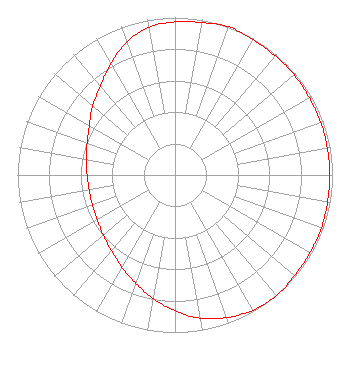 | ||||||||||||||||||
| Azimuth | Ratio | Azimuth | Ratio | Azimuth | Ratio | Azimuth | Ratio | ||||||||||||
| 0 | 0.973 | 10 | 0.983 | 20 | 1.000 | 30 | 0.992 | ||||||||||||
| 40 | 0.988 | 50 | 0.988 | 60 | 0.983 | 70 | 0.983 | ||||||||||||
| 80 | 0.983 | 90 | 0.983 | 100 | 0.983 | 110 | 0.988 | ||||||||||||
| 120 | 0.988 | 130 | 0.992 | 140 | 1.000 | 150 | 0.991 | ||||||||||||
| 160 | 0.963 | 170 | 0.923 | 180 | 0.862 | 190 | 0.797 | ||||||||||||
| 200 | 0.731 | 210 | 0.676 | 220 | 0.628 | 230 | 0.594 | ||||||||||||
| 240 | 0.571 | 250 | 0.558 | 260 | 0.553 | 270 | 0.558 | ||||||||||||
| 280 | 0.571 | 290 | 0.594 | 300 | 0.628 | 310 | 0.682 | ||||||||||||
| 320 | 0.738 | 330 | 0.815 | 340 | 0.897 | 350 | 0.953 | ||||||||||||
Structure Registration Number 1264545 Structure Type: BMAST Registered To: MediaFLO USA Structure Address: Wells Fargo Center, 30 E. 7th Street St. Paul, MN County Name: Ramsey County ASR Issued: 09/26/2008 Date Built: 08/19/2008 Site Elevation: 235.3 m (772 ft.) Structure Height: 143.9 m (472 ft.) Height Overall: 153.6 m (504 ft.) Overall Height AMSL: 388.9 m (1276 ft.) FAA Determination: 07/14/2008 FAA Study #: 2008-AGL-3720-OE FAA Circular #: 70/7460-1K Paint & Light FAA Chapters: 4, 5, 12 PRIOR STUDY 2001-AGL-1439-OE 44-56-53.4 N 93-05-44.3 W (NAD 83) 44-56-53.5 N 93-05-43.5 W (Converted to NAD 27) |
P.o. Box 25130 St. Paul, MN 55125 Phone: 651-436-4000 | Date: 02/02/2017 Application Certifier 630 RADIO, INCORPORATED P.o. Box 25130 St. Paul, MN 55125 Applicant MARK A. MUELLER Mueller Broadcast Design 613 S. La Grange Rd. La Grange, IL 60525-5601 TECHNICAL CONSULTANT JAMES A. KOERNER, ESQ. Koerner & Olender, P.c. 7020 Richard Drive Bethesda, MD 20817 | |||||||||||||||||