
FCCInfo.com
A Service of Cavell, Mertz & Associates, Inc.
(855) FCC-INFO
|
|
WKJL from 10/21/1992 |
|
|
||||||||||||||||
|
|
WKJL Channel: 201B 88.1 MHz Clarksburg, West Virginia Service: FM - A full-service FM station or application. Facility ID: 26526 Fac. Service: FM Status: License Application Accepted: 09/10/2009 Application Granted: 09/21/2009 File Number: BLED-20090910AAV License Expires: 00/00/0000 Prefix Type: This is a license for a noncommercial educational FM station Application Type: Amendment FCC Website Links: LMS Facility Details This Application CDBS Application Other WKJL Applications Other WKJL Applications in CDBS Including Superseded Applications Mailing Address Correspondence for WKJL Correspondence related to application BLED-20090910AAV Service Contour - Open Street Map or USGS Map (60 dBu) Service Contour - KML / Google Earth (60 dBu) Public Inspection Files Facility Type: NON-COMMERCIAL EDUC. FM Class: B, A Zone I or I-A station; with 25kW-50kW ERP and a class contour distance 39km-52km Site Location: 39-17-59.3 N 80-17-29.3 W (NAD 83) Site Location: 39-17-59.0 N 80-17-30.0 W (Converted to NAD 27) Effective Radiated Power: 19 kW Horiz. ; 32 kW Vert. Transmitter Output Power: 9.22 kW Antenna Center HAAT: 149 m (489 ft.) Antenna Center AMSL: 512 m (1680 ft.) Antenna Center HAG: 83.8 m (275 ft.) Calculated Site Elevation: 428.2 m. (1405 ft.) Height Overall*: 98.8 m (324 ft.) (* As Filed In This Application, may differ from ASR Data, Below.) Directional Antenna Antenna Make/Model: Propagation System Inc FMR-4C-DA Antenna ID: 92333 Polarization:
| ||||||||||||||||||
| Antenna Data for Antenna Id: 92333 WKJL FM File: BLED-20090910AAV Propagation System Inc - FMR-4C-DA Service: FM | 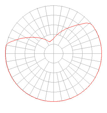 | ||||||||||||||||||
| Azimuth | Ratio | Azimuth | Ratio | Azimuth | Ratio | Azimuth | Ratio | ||||||||||||
| 0 | 0.309 | 10 | 0.388 | 20 | 0.488 | 30 | 0.614 | ||||||||||||
| 40 | 0.772 | 50 | 0.970 | 60 | 1.000 | 70 | 1.000 | ||||||||||||
| 80 | 1.000 | 90 | 1.000 | 100 | 1.000 | 110 | 1.000 | ||||||||||||
| 120 | 1.000 | 130 | 1.000 | 140 | 1.000 | 150 | 1.000 | ||||||||||||
| 160 | 1.000 | 170 | 1.000 | 180 | 1.000 | 190 | 1.000 | ||||||||||||
| 200 | 1.000 | 210 | 1.000 | 220 | 1.000 | 230 | 1.000 | ||||||||||||
| 240 | 1.000 | 250 | 1.000 | 260 | 1.000 | 270 | 1.000 | ||||||||||||
| 280 | 0.999 | 290 | 0.826 | 300 | 0.656 | 310 | 0.522 | ||||||||||||
| 320 | 0.415 | 330 | 0.330 | 340 | 0.263 | 350 | 0.272 | ||||||||||||
Structure Registration Number 1034533 Structure Type: TOWER Registered To: WITHERS BROADCASTING COMPANY OF BRIDGEPORT, LLC Structure Address: 1.1 Km West Of I-79, 1.4 Km Sw Of Country Club Bridgeport, WV County Name: Harrison County ASR Issued: 11/07/2016 Date Built: 09/01/1994 Site Elevation: 428.2 m (1405 ft.) Structure Height: 97.5 m (320 ft.) Height Overall: 98.8 m (324 ft.) Overall Height AMSL: 527 m (1729 ft.) FAA Determination: 09/24/1992 FAA Study #: 92-AEA-0565-OE FAA Circular #: 70/7460-1H Paint & Light FAA Chapters: 3, 4, 5, 13 39-17-59.0 N 80-17-29.0 W (NAD 83) 39-17-58.7 N 80-17-29.7 W (Converted to NAD 27) |
5700 West Oaks Blvd. Rocklin, CA 95765 Phone: 916-251-1600 Not-for-Profit | Date: 09/10/2009 Application Certifier HE'S ALIVE, INC. 34 Springs Road P. O. Box 540 Grantsville, MD 21536 Applicant LAURA M. MIZRAHI Communications Technologies, Inc. P. O. Box 1130 Marlton, NJ 08053 TECHNICAL CONSULTANT LEE J. PELTZMAN Shainis & Peltzman, Chartered | |||||||||||||||||