
FCCInfo.com
A Service of Cavell, Mertz & Associates, Inc.
(855) FCC-INFO
|
|
W277CA from 01/15/2009 W277CA from 12/04/2008 W277CA from 09/28/1998 |
|
|
||||||||||||||||
|
|
W277CA Channel: 277D 103.3 MHz Union City, Tennessee Service: FX - A translator or application for a translator. Facility ID: 90233 Fac. Service: FX Programming Delivery Method: Unspecified Status: License Application Accepted: 10/10/2017 Application Granted: 10/18/2017 File Number: BLFT-20171010AAG License Expires: 00/00/0000 Prefix Type: This is a license for a translator Application Type: License To Cover FCC Website Links: LMS Facility Details This Application CDBS Application Other W277CA Applications Other W277CA Applications in CDBS Including Superseded Applications Mailing Address Correspondence for W277CA Correspondence related to application BLFT-20171010AAG Service Contour - Open Street Map or USGS Map (60 dBu) Service Contour - KML / Google Earth (60 dBu) Class: D, A Noncommercial educational operating with no more than 10W Site Location: 36-24-47.2 N 89-08-59.2 W (NAD 83) Site Location: 36-24-47.0 N 89-08-59.0 W (Converted to NAD 27) Effective Radiated Power: 0.25 kW Transmitter Output Power: 0.1 kW Antenna Center HAAT: 0 m Antenna Center AMSL: 298 m (978 ft.) Antenna Center HAG: 145 m (476 ft.) Site Elevation: 153 m. (502 ft.) Height Overall*: 177 m (581 ft.) (* As Filed In This Application, may differ from ASR Data, Below.) Directional Antenna Antenna Make/Model: None Antenna ID: 129370 Polarization:
| ||||||||||||||||||
| Antenna Data for Antenna Id: 129370 W277CA FX File: BLFT-20171010AAG None - Service: FX | 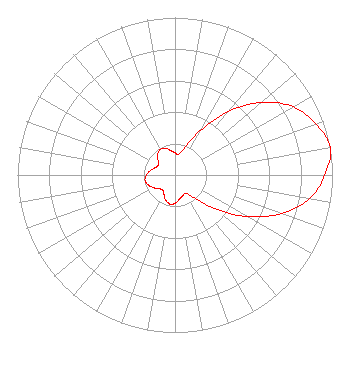 | ||||||||||||||||||
| Azimuth | Ratio | Azimuth | Ratio | Azimuth | Ratio | Azimuth | Ratio | ||||||||||||
| 0 | 0.142 | 10 | 0.134 | 20 | 0.190 | 30 | 0.329 | ||||||||||||
| 40 | 0.528 | 50 | 0.718 | 60 | 0.866 | 70 | 0.952 | ||||||||||||
| 80 | 1.000 | 90 | 0.952 | 100 | 0.866 | 110 | 0.718 | ||||||||||||
| 120 | 0.528 | 130 | 0.329 | 140 | 0.190 | 150 | 0.134 | ||||||||||||
| 160 | 0.142 | 170 | 0.157 | 180 | 0.181 | 190 | 0.187 | ||||||||||||
| 200 | 0.171 | 210 | 0.140 | 220 | 0.123 | 230 | 0.135 | ||||||||||||
| 240 | 0.160 | 250 | 0.182 | 260 | 0.193 | 270 | 0.182 | ||||||||||||
| 280 | 0.160 | 290 | 0.135 | 300 | 0.123 | 310 | 0.140 | ||||||||||||
| 320 | 0.171 | 330 | 0.187 | 340 | 0.181 | 350 | 0.157 | ||||||||||||
Structure Registration Number 1023191 Structure Type: TOWER Registered To: WOOD COMMUNICATIONS Structure Address: 2567 Dallas Hill Road West Union City, TN County Name: Obion County ASR Issued: 10/26/1999 Date Built: 12/15/1999 Site Elevation: 152.7 m (501 ft.) Structure Height: 171.3 m (562 ft.) Height Overall: 177.4 m (582 ft.) Overall Height AMSL: 330.1 m (1083 ft.) FAA Determination: 08/31/1998 FAA Study #: 98-ASO-3824-OE FAA Circular #: 70/7460-1J Paint & Light FAA Chapters: 4, 5, 7, 9, 13 PREV. 95-ASO-2355-OE. PROJECT COMPLETED 3/1/99 36-24-47.0 N 89-08-59.0 W (NAD 83) 36-24-46.8 N 89-08-58.8 W (Converted to NAD 27) |
P.o. Box 318 Martin, TN 38237 Phone: 713-587-9526 Corporation | Date: 10/10/2017 Application Certifier THUNDERBOLT BROADCASTING COMPANY P.o. Box 318 Martin, TN 38237 Applicant CHARLES M. ANDERSON 1519 Euclid Avenue Bowling Green, KY 42103 CONSULTANT PAUL TINKLE Thunderbolt Broadcasting P.o. Box 318 Martin, TN 38237 | |||||||||||||||||