
FCCInfo.com
A Service of Cavell, Mertz & Associates, Inc.
(855) FCC-INFO
|
|
|
|
|
||||||||||||||||
|
|
WSVH Channel: 216C0 91.1 MHz Savannah, Georgia Service: FM - A full-service FM station or application. Facility ID: 23926 Fac. Service: FM Analog & Digital Status: License Application Accepted: 09/09/2008 Application Granted: 09/30/2008 File Number: BLED-20080909ABI License Expires: 00/00/0000 Prefix Type: This is a license for a noncommercial educational FM station Application Type: License To Cover FCC Website Links: LMS Facility Details This Application CDBS Application Other WSVH Applications Other WSVH Applications in CDBS Including Superseded Applications Mailing Address Correspondence for WSVH Correspondence related to application BLED-20080909ABI Service Contour - Open Street Map or USGS Map (60 dBu) Service Contour - KML / Google Earth (60 dBu) Public Inspection Files History Cards for WSVH Facility Type: NON-COMMERCIAL EDUC. FM Class: C0, C0 Site Location: 32-08-48.7 N 81-37-04.4 W (NAD 83) Site Location: 32-08-48.0 N 81-37-05.0 W (Converted to NAD 27) Effective Radiated Power: 0 kW Horiz. ; 96 kW Vert. Transmitter Output Power: 14.3 kW Antenna Center HAAT: 0 m Horiz.; 430.9 m Vert. Antenna Center AMSL: 0 m Horiz.; 456 m Vert. Antenna Center HAG: 0 m Horiz.; 427 m Vert. Site Elevation: 29 m. (95 ft.) Height Overall*: 437.4 m (1435 ft.) (* As Filed In This Application, may differ from ASR Data, Below.) Directional Antenna Antenna Make/Model: DIELECTRIC DCV5E-R Antenna ID: 78038 Polarization: | ||||||||||||||||||
| Antenna Data for Antenna Id: 78038 WSVH FM File: BLED-20080909ABI DIELECTRIC - DCV5E-R Service: FM | 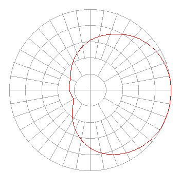 | ||||||||||||||||||
| Azimuth | Ratio | Azimuth | Ratio | Azimuth | Ratio | Azimuth | Ratio | ||||||||||||
| 0 | 0.610 | 10 | 0.672 | 20 | 0.729 | 30 | 0.793 | ||||||||||||
| 40 | 0.854 | 50 | 0.904 | 60 | 0.944 | 70 | 0.973 | ||||||||||||
| 80 | 0.992 | 90 | 1.000 | 100 | 1.000 | 110 | 0.999 | ||||||||||||
| 120 | 0.990 | 130 | 0.970 | 140 | 0.941 | 150 | 0.901 | ||||||||||||
| 160 | 0.852 | 170 | 0.792 | 180 | 0.716 | 190 | 0.627 | ||||||||||||
| 200 | 0.528 | 210 | 0.429 | 220 | 0.341 | 230 | 0.271 | ||||||||||||
| 240 | 0.236 | 250 | 0.235 | 260 | 0.243 | 270 | 0.256 | ||||||||||||
| 280 | 0.262 | 290 | 0.266 | 300 | 0.281 | 310 | 0.311 | ||||||||||||
| 320 | 0.357 | 330 | 0.412 | 340 | 0.473 | 350 | 0.540 | ||||||||||||
Structure Registration Number 1258262 Structure Type: GTOWER Registered To: Georgia Public Telecommunications Commission Structure Address: S End Of Vandiver Street, Pembroke Ga Pembroke, GA County Name: Bryan County ASR Issued: 01/05/2024 Date Built: 05/12/2008 Site Elevation: 29 m (95 ft.) Structure Height: 417.9 m (1371 ft.) Height Overall: 437.4 m (1435 ft.) Overall Height AMSL: 466.4 m (1530 ft.) FAA Determination: 10/24/2023 FAA Study #: 2023-ASO-29630-OE FAA Circular #: 70/7460-1M Paint & Light FAA Chapters: 4, 9, 15 PRIOR STUDY 2005-ASO-1781-OE 32-08-49.0 N 81-37-04.0 W (NAD 83) 32-08-48.3 N 81-37-04.6 W (Converted to NAD 27) |
260 14th St Nw Atlanta, GA 30318-5360 Phone: 404-685-2410 Government Entity | Date: 09/09/2008 Application Certifier GEORGIA PUBLIC TELECOMMUNICATIONS COMMISSION 260 Fourteenth Street, N.w. Atlanta, GA 30318 Applicant WILLIAM T. GODFREY, JR. Kessler And Gehman Associates, Inc. 507 Nw 60th Street, Suite C Gainesville, FL 32607-2702 CONSULTING ENGINEER THEODORE D. FRANK Arnold & Porter Llp | |||||||||||||||||