
FCCInfo.com
A Service of Cavell, Mertz & Associates, Inc.
(855) FCC-INFO
|
|
|
|
|
||||||||||||||||
|
|
KUCV Channel: 216C1 91.1 MHz Lincoln, Nebraska Service: FM - A full-service FM station or application. Facility ID: 47966 Fac. Service: FM Analog & Digital Status: License Application Accepted: 02/28/2013 Application Granted: 03/07/2013 File Number: BMLED-20130228AMW License Expires: 00/00/0000 Prefix Type: This is a modification of license for a noncommercial educational FM station Application Type: Minor Modification FCC Website Links: LMS Facility Details This Application CDBS Application Other KUCV Applications Other KUCV Applications in CDBS Including Superseded Applications Mailing Address Correspondence for KUCV Correspondence related to application BMLED-20130228AMW Service Contour - Open Street Map or USGS Map (60 dBu) Service Contour - KML / Google Earth (60 dBu) Public Inspection Files History Cards for KUCV Facility Type: NON-COMMERCIAL EDUC. FM Class: C1, A Zone II station; with 50kW-100kW ERP and a class contour distance 52km-72km Site Location: 40-31-06.0 N 96-46-07.1 W (NAD 83) Site Location: 40-31-06.0 N 96-46-06.0 W (Converted to NAD 27) Effective Radiated Power: 19.5 kW Horiz. ; 100 kW Vert. Transmitter Output Power: 21.45 kW Antenna Center HAAT: 210 m (689 ft.) Antenna Center AMSL: 641 m (2103 ft.) Antenna Center HAG: 190 m (623 ft.) Site Elevation: 451 m. (1480 ft.) Height Overall*: 234 m (768 ft.) (* As Filed In This Application, may differ from ASR Data, Below.) Directional Antenna Antenna Make/Model: None ERI SHPX-4AE-DA, 4 section Antenna ID: 35205 Polarization:
| ||||||||||||||||||
| Antenna Data for Antenna Id: 35205 KUCV FM File: BMLED-20130228AMW None - ERI SHPX-4AE-DA, 4 section Service: FM | 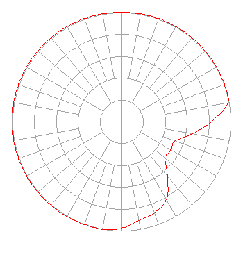 | ||||||||||||||||||
| Azimuth | Ratio | Azimuth | Ratio | Azimuth | Ratio | Azimuth | Ratio | ||||||||||||
| 0 | 1.000 | 10 | 1.000 | 20 | 1.000 | 30 | 1.000 | ||||||||||||
| 40 | 1.000 | 50 | 1.000 | 60 | 1.000 | 70 | 1.000 | ||||||||||||
| 80 | 0.990 | 90 | 0.822 | 100 | 0.655 | 110 | 0.520 | ||||||||||||
| 120 | 0.520 | 130 | 0.520 | 140 | 0.655 | 150 | 0.822 | ||||||||||||
| 160 | 0.889 | 170 | 0.920 | 180 | 0.975 | 190 | 1.000 | ||||||||||||
| 200 | 1.000 | 210 | 1.000 | 220 | 1.000 | 230 | 1.000 | ||||||||||||
| 240 | 1.000 | 250 | 1.000 | 260 | 1.000 | 270 | 1.000 | ||||||||||||
| 280 | 1.000 | 290 | 1.000 | 300 | 1.000 | 310 | 1.000 | ||||||||||||
| 320 | 1.000 | 330 | 1.000 | 340 | 1.000 | 350 | 1.000 | ||||||||||||
Structure Registration Number 1026482 [ASR Heights Differ from KUCV Application] Structure Type: GTOWER Registered To: Vertical Bridge S3 Assets, LLC Structure Address: 1.2 Mi Se / Us-ne-5032 Hallam, NE County Name: Gage County ASR Issued: 01/14/2021 Date Built: 04/01/1988 Site Elevation: 452.3 m (1484 ft.) Structure Height: 234.3 m (769 ft.) Height Overall: 235.6 m (773 ft.) Overall Height AMSL: 687.9 m (2257 ft.) FAA Determination: 10/27/2020 FAA Study #: 2020-ACE-5640-OE FAA Circular #: 70/7460-1J Paint & Light FAA Chapters: 3, 4, 5, 13 OM&L to remain the same as prior study = PAINT/RED LIGHTS 40-31-05.6 N 96-46-06.4 W (NAD 83) 40-31-05.6 N 96-46-05.3 W (Converted to NAD 27) |
1800 N. 33rd Street Lincoln, NE 68503 Phone: 402-472-9333 Government Entity | Date: 02/28/2013 Application Certifier NEBRASKA EDUCATIONAL TELECOMMUNICATIONS COMMISSION 1800 N. 33rd Street Lincoln, NE 68503 Applicant DOUG VERNIER Telecommunications Consultants 401 Main St., Suite 213 Cedar Falls, IA 50613 ENGINEERING CONSULTANT BARRY PERSH Dow Lohnes Pllc | |||||||||||||||||
| |||||||||||||||||||