
FCCInfo.com
A Service of Cavell, Mertz & Associates, Inc.
(855) FCC-INFO
|
|
|
|
|
||||||||||||||||
|
|
K269EW Channel: 269D 101.7 MHz Santa Maria, California Service: FX - A translator or application for a translator. Facility ID: 142365 Fac. Service: FX Programming Delivery Method: Unspecified Status: License Application Accepted: 11/13/2006 Application Granted: 01/09/2007 File Number: BLFT-20061113ACR License Expires: 00/00/0000 Prefix Type: This is a license for a translator Application Type: License To Cover FCC Website Links: LMS Facility Details This Application CDBS Application Other K269EW Applications Other K269EW Applications in CDBS Including Superseded Applications Mailing Address Correspondence for K269EW Correspondence related to application BLFT-20061113ACR Service Contour - Open Street Map or USGS Map (60 dBu) Service Contour - KML / Google Earth (60 dBu) Class: D, A Noncommercial educational operating with no more than 10W Site Location: 34-54-37.0 N 120-11-13.0 W (NAD 83) Site Location: 34-54-37.1 N 120-11-09.5 W (Converted to NAD 27) Effective Radiated Power: 0.01 kW Transmitter Output Power: 0.036 kW Antenna Center HAAT: 585.9 m Horiz.; 0 m Vert. Antenna Center AMSL: 1005 m (3297 ft.) Antenna Center HAG: 15 m (49 ft.) Site Elevation: 990 m. (3248 ft.) Height Overall*: 44 m (144 ft.) (* As Filed In This Application, may differ from ASR Data, Below.) Directional Antenna Antenna Make/Model: None Antenna ID: 76025 Polarization:
| ||||||||||||||||||
| Antenna Data for Antenna Id: 76025 K269EW FX File: BLFT-20061113ACR None - Service: FX Pattern and Field Values Include a 288° Clockwise Rotation | 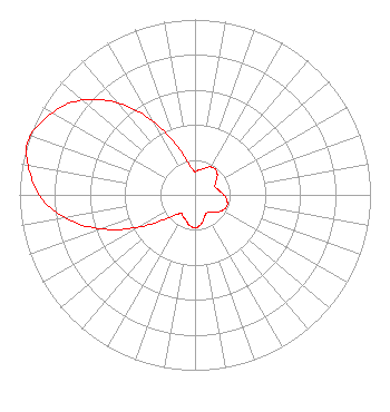 | ||||||||||||||||||
| Azimuth | Ratio | Azimuth | Ratio | Azimuth | Ratio | Azimuth | Ratio | ||||||||||||
| 8 | 0.142 | 18 | 0.157 | 28 | 0.181 | 38 | 0.187 | ||||||||||||
| 48 | 0.171 | 58 | 0.140 | 68 | 0.123 | 78 | 0.135 | ||||||||||||
| 88 | 0.160 | 98 | 0.182 | 108 | 0.193 | 118 | 0.182 | ||||||||||||
| 128 | 0.160 | 138 | 0.135 | 148 | 0.123 | 158 | 0.140 | ||||||||||||
| 168 | 0.171 | 178 | 0.187 | 188 | 0.181 | 198 | 0.157 | ||||||||||||
| 208 | 0.142 | 218 | 0.134 | 228 | 0.190 | 238 | 0.329 | ||||||||||||
| 248 | 0.528 | 258 | 0.718 | 268 | 0.866 | 278 | 0.952 | ||||||||||||
| 288 | 1.000 | 298 | 0.952 | 308 | 0.866 | 318 | 0.718 | ||||||||||||
| 328 | 0.528 | 338 | 0.329 | 348 | 0.190 | 358 | 0.134 | ||||||||||||
Structure Registration Number 1032645 Structure Type: TOWER Registered To: VistaWest California, LLC Structure Address: Atop Tepusquet Peak Santa Maria, CA County Name: Santa Barbara County ASR Issued: 03/02/2015 Date Built: 01/01/1964 Site Elevation: 990 m (3248 ft.) Structure Height: 30.9 m (101 ft.) Height Overall: 43.9 m (144 ft.) Overall Height AMSL: 1033.9 m (3392 ft.) FAA Determination: 12/18/1997 FAA Study #: 97-AWP-3187-OE FAA Circular #: 70/7460-1J Paint & Light FAA Chapters: 3, 4, 5, 13 34-54-37.0 N 120-11-13.0 W (NAD 83) 34-54-37.1 N 120-11-09.5 W (Converted to NAD 27) |
2310 Ponderosa Drive Suite 28 Camarillo, CA 93010-4747 Phone: 805-482-4797 | Date: 11/13/2006 Application Certifier THE ASSOCIATION FOR COMMUNITY EDUCATION, INC 2310 Ponderosa Drive Suite 28 Camarillo, CA 93010 Applicant CHRIS COMPTON 44008 Hoban Ave Lancaster, CA 93534-4210 CONSULTING ENGINNER JOHN NEELY, ESQ. Miller And Neely, P.c. Suite 704 6900 Wisconsin Ave. Bethesda, MD 20815 | |||||||||||||||||