
FCCInfo.com
A Service of Cavell, Mertz & Associates, Inc.
(855) FCC-INFO
|
|
KCRU from 12/13/1991 |
|
|
||||||||||||||||
|
|
KCRU Channel: 206A 89.1 MHz Oxnard, California Service: FM - A full-service FM station or application. Facility ID: 59085 Fac. Service: FM Analog & Digital Status: License Application Accepted: 04/22/2004 Application Granted: 05/05/2004 File Number: BLED-20040422ABU License Expires: 00/00/0000 Prefix Type: This is a license for a noncommercial educational FM station Application Type: License To Cover FCC Website Links: LMS Facility Details This Application CDBS Application Other KCRU Applications Other KCRU Applications in CDBS Including Superseded Applications Mailing Address Correspondence for KCRU Correspondence related to application BLED-20040422ABU Service Contour - Open Street Map or USGS Map (60 dBu) Service Contour - KML / Google Earth (60 dBu) Public Inspection Files Facility Type: NON-COMMERCIAL EDUC. FM Class: A, A Zone I; I-A; or II station; with 0.1kW-6kW ERP and a class contour distance <=28km Site Location: 34-06-47.0 N 119-03-37.4 W (NAD 83) Site Location: 34-06-47.0 N 119-03-34.0 W (Converted to NAD 27) Effective Radiated Power: 0.85 kW Transmitter Output Power: 0.351 kW Antenna Center HAAT: 260 m (853 ft.) Antenna Center AMSL: 405 m (1329 ft.) Antenna Center HAG: 15 m (49 ft.) Site Elevation: 390 m. (1280 ft.) Height Overall*: 31 m (102 ft.) (* As Filed In This Application, may differ from ASR Data, Below.) Directional Antenna Antenna Make/Model: Scala COMPOSITE CA-5FM/CP/RM Antenna ID: 41326 Polarization:
| ||||||||||||||||||
| Antenna Data for Antenna Id: 41326 KCRU FM File: BLED-20040422ABU Scala - COMPOSITE CA-5FM/CP/RM Service: FM | 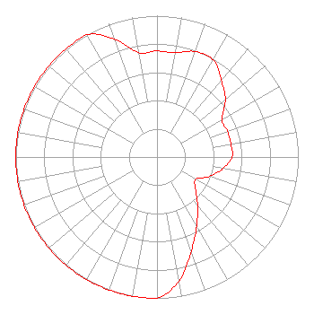 | ||||||||||||||||||
| Azimuth | Ratio | Azimuth | Ratio | Azimuth | Ratio | Azimuth | Ratio | ||||||||||||
| 0 | 0.750 | 10 | 0.750 | 20 | 0.794 | 30 | 0.794 | ||||||||||||
| 40 | 0.708 | 50 | 0.631 | 60 | 0.531 | 70 | 0.531 | ||||||||||||
| 80 | 0.531 | 90 | 0.531 | 100 | 0.473 | 110 | 0.398 | ||||||||||||
| 120 | 0.316 | 130 | 0.355 | 140 | 0.447 | 150 | 0.562 | ||||||||||||
| 160 | 0.708 | 170 | 0.891 | 180 | 1.000 | 190 | 1.000 | ||||||||||||
| 200 | 1.000 | 210 | 1.000 | 220 | 1.000 | 230 | 1.000 | ||||||||||||
| 240 | 1.000 | 250 | 1.000 | 260 | 1.000 | 270 | 1.000 | ||||||||||||
| 280 | 1.000 | 290 | 1.000 | 300 | 1.000 | 310 | 1.000 | ||||||||||||
| 320 | 1.000 | 330 | 1.000 | 340 | 0.891 | 350 | 0.750 | ||||||||||||
Structure Registration Number 1064773 [ASR Heights Differ from KCRU Application] Structure Type: TOWER Registered To: Collins Tower Corp. Structure Address: Laguna Peak Ventura, CA County Name: Ventura County ASR Issued: 07/26/2002 Date Built: 10/25/1996 Site Elevation: 390.1 m (1280 ft.) Structure Height: 30.5 m (100 ft.) Height Overall: 30.5 m (100 ft.) Overall Height AMSL: 420.6 m (1380 ft.) FAA Determination: 07/17/2002 FAA Study #: 02-AWP-2275-OE Paint & Light FAA Chapters: NONE PRIOR STUDY 02-AWP-1403-OE 34-06-47.0 N 119-03-37.4 W (NAD 83) 34-06-47.0 N 119-03-34.0 W (Converted to NAD 27) |
1900 Pico Blvd Santa Monica, CA 90405-1628 Phone: 310-434-4000 | Date: 04/22/2004 Application Certifier SANTA MONICA COMMUNITY COLLEGE DISTRICT 1900 Pico Blvd. Santa Monica, CA 91405-1628 Applicant JOHN J. DAVIS Po Box 128 Sierra Madre, CA 91025-0128 CONSULTING ENGINEER ANDREW S. KERSTING, ESQ. Dickstein Shapiro Morin & Oshinsky Llp | |||||||||||||||||