
FCCInfo.com
A Service of Cavell, Mertz & Associates, Inc.
(855) FCC-INFO
|
|
K237FI from 08/11/2011 K237FI from 05/27/2011 K237FI from 10/04/2004 |
|
|
||||||||||||||||
|
|
K237FI Channel: 237D 95.3 MHz Jonesboro, Arkansas Service: FX - A translator or application for a translator. Facility ID: 146186 Fac. Service: FX Programming Delivery Method: Unspecified Status: License Application Accepted: 05/09/2012 Application Granted: 06/07/2012 File Number: BLFT-20120509AFJ License Expires: 00/00/0000 Prefix Type: This is a license for a translator Application Type: License To Cover FCC Website Links: LMS Facility Details This Application CDBS Application Other K237FI Applications Other K237FI Applications in CDBS Including Superseded Applications Mailing Address Correspondence for K237FI Correspondence related to application BLFT-20120509AFJ Service Contour - Open Street Map or USGS Map (60 dBu) Service Contour - KML / Google Earth (60 dBu) Class: D, A Noncommercial educational operating with no more than 10W Site Location: 35-47-56.3 N 90-44-31.4 W (NAD 83) Site Location: 35-47-56.0 N 90-44-31.0 W (Converted to NAD 27) Effective Radiated Power: 0.25 kW Transmitter Output Power: 0.344 kW Antenna Center HAAT: 162.2 m Horiz.; 0 m Vert. Antenna Center AMSL: 243 m (797 ft.) Antenna Center HAG: 115 m (377 ft.) Site Elevation: 128 m. (420 ft.) Height Overall*: 157 m (515 ft.) (* As Filed In This Application, may differ from ASR Data, Below.) Directional Antenna Antenna Make/Model: None Antenna ID: 106156 Polarization:
| ||||||||||||||||||
| Antenna Data for Antenna Id: 106156 K237FI FX File: BLFT-20120509AFJ None - Service: FX | 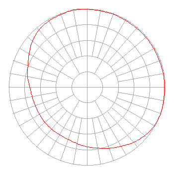 | ||||||||||||||||||
| Azimuth | Ratio | Azimuth | Ratio | Azimuth | Ratio | Azimuth | Ratio | ||||||||||||
| 0 | 0.992 | 10 | 0.988 | 20 | 0.988 | 30 | 0.983 | ||||||||||||
| 40 | 0.983 | 50 | 0.983 | 60 | 0.983 | 70 | 0.983 | ||||||||||||
| 80 | 0.988 | 90 | 0.988 | 100 | 0.992 | 110 | 1.000 | ||||||||||||
| 120 | 0.991 | 130 | 0.963 | 140 | 0.923 | 150 | 0.873 | ||||||||||||
| 160 | 0.832 | 170 | 0.792 | 180 | 0.762 | 190 | 0.732 | ||||||||||||
| 200 | 0.710 | 210 | 0.702 | 220 | 0.702 | 230 | 0.702 | ||||||||||||
| 240 | 0.702 | 250 | 0.702 | 260 | 0.712 | 270 | 0.732 | ||||||||||||
| 280 | 0.772 | 290 | 0.802 | 300 | 0.853 | 310 | 0.909 | ||||||||||||
| 320 | 0.953 | 330 | 0.973 | 340 | 0.983 | 350 | 1.000 | ||||||||||||
Structure Registration Number 1038729 Structure Type: TOWER Registered To: East Arkansas Broadcasters of Jonesboro, LLC Structure Address: 2510 Neely Ln Jonesboro, AR County Name: Craighead County ASR Issued: 04/08/2011 Date Built: 01/01/1973 Site Elevation: 128.3 m (421 ft.) Structure Height: 153.3 m (503 ft.) Height Overall: 156.7 m (514 ft.) Overall Height AMSL: 285 m (935 ft.) FAA Determination: 04/10/1998 FAA Study #: 98-ASW-1099-OE FAA Circular #: 70/7460-1J Paint & Light FAA Chapters: 3, 4, 5, 13 35-47-56.0 N 90-44-31.0 W (NAD 83) 35-47-55.7 N 90-44-30.6 W (Converted to NAD 27) |
P.o. Box 789 Highway 64 West Wynne, AR 72396 Phone: 870-238-8141 Corporation | Date: 05/09/2012 Application Certifier EAST ARKANSAS BROADCASTERS, INC. P.o. Box 789 Wynne, AR 72396 Applicant PALMER JOHNSON P.o. Box 832 Kennett, MO 63857 ENGINEER JOHN F. GARZIGLIA, ESQ. Womble Carlyle Sandridge & Rice, Llp 1200 19th Street, N.w., Suite 500 Washington, DC 20036 | |||||||||||||||||