
FCCInfo.com
A Service of Cavell, Mertz & Associates, Inc.
(855) FCC-INFO
|
|
WFSS from 07/31/1978 |
|  |
|
|||||||||||||||
|
|
WFSS Channel: 220C1 91.9 MHz Fayetteville, North Carolina Service: FM - A full-service FM station or application. Facility ID: 21241 Fac. Service: FM Status: License 73.215 Station Application Accepted: 03/24/1993 Application Granted: 05/13/1993 File Number: BLED-19930324KA License Expires: 12/01/1995 Prefix Type: This is a license for a noncommercial educational FM station Application Type: License To Cover FCC Website Links: LMS Facility Details This Application CDBS Application Other WFSS Applications Other WFSS Applications in CDBS Including Superseded Applications Mailing Address Correspondence for WFSS Correspondence related to application BLED-19930324KA Service Contour - Open Street Map or USGS Map (60 dBu) Service Contour - KML / Google Earth (60 dBu) Public Inspection Files History Cards for WFSS Facility Type: NON-COMMERCIAL EDUC. FM Class: C1, A Zone II station; with 50kW-100kW ERP and a class contour distance 52km-72km Site Location: 35-04-22.6 N 78-53-26.1 W (NAD 83) Site Location: 35-04-22.0 N 78-53-27.0 W (Converted to NAD 27) Effective Radiated Power: 100 kW Antenna Center HAAT: 107 m (351 ft.) Antenna Center AMSL: 157 m (515 ft.) Antenna Center HAG: 123 m (404 ft.) Calculated Site Elevation: 34 m. (112 ft.) Height Overall*: 134 m (440 ft.) (* As Filed In This Application, may differ from ASR Data, Below.) Directional Antenna Antenna Make/Model: Oddball; usually designed by Applicant ODD920921IB Antenna ID: 14417 Polarization:
| ||||||||||||||||||
| Antenna Data for Antenna Id: 14417 WFSS FM File: BLED-19930324KA Oddball; usually designed by Applicant - ODD920921IB Service: FM | 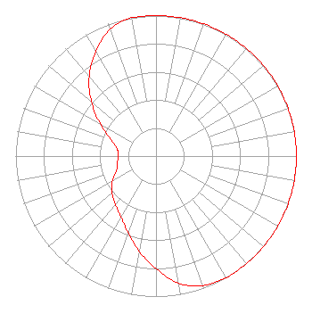 | ||||||||||||||||||
| Azimuth | Ratio | Azimuth | Ratio | Azimuth | Ratio | Azimuth | Ratio | ||||||||||||
| 0 | 1.000 | 10 | 1.000 | 20 | 1.000 | 30 | 1.000 | ||||||||||||
| 40 | 1.000 | 50 | 1.000 | 60 | 1.000 | 70 | 1.000 | ||||||||||||
| 80 | 1.000 | 90 | 1.000 | 100 | 1.000 | 110 | 1.000 | ||||||||||||
| 120 | 1.000 | 130 | 1.000 | 140 | 1.000 | 150 | 1.000 | ||||||||||||
| 160 | 0.980 | 170 | 0.920 | 180 | 0.800 | 190 | 0.690 | ||||||||||||
| 200 | 0.580 | 210 | 0.500 | 220 | 0.450 | 230 | 0.410 | ||||||||||||
| 240 | 0.360 | 250 | 0.300 | 260 | 0.280 | 270 | 0.270 | ||||||||||||
| 280 | 0.280 | 290 | 0.340 | 300 | 0.460 | 310 | 0.600 | ||||||||||||
| 320 | 0.740 | 330 | 0.860 | 340 | 0.960 | 350 | 1.000 | ||||||||||||
Structure Registration Number 1005394 [ASR Heights Differ from WFSS Application] Structure Type: TOWER Registered To: FAYETTEVILLE STATE UNIVERSITY DBA = WFSS FM Structure Address: On The Campus Of Fayetteville State Univ Fayetteville, NC County Name: Cumberland County ASR Issued: 12/19/1996 Date Built: 01/01/1983 Site Elevation: 33.5 m (110 ft.) Structure Height: 132.9 m (436 ft.) Height Overall: 134.1 m (440 ft.) Overall Height AMSL: 167.6 m (550 ft.) Paint & Light FAA Chapters: 1, 3, 12, 21 35-04-23.0 N 78-53-26.0 W (NAD 83) 35-04-22.4 N 78-53-26.9 W (Converted to NAD 27) |
Campus Box 0915 120 Friday Center Drive Chapel Hill, NC 27517 Phone: 919-445-9146 Non-Profit LLC | Date: 03/24/1993 Application Certifier FAYETTEVILLE STATE UNIVERSITY Fayetteville State University 1200 Murchison Road Fayetteville, NC 28301 Applicant | |||||||||||||||||
| |||||||||||||||||||