
FCCInfo.com
A Service of Cavell, Mertz & Associates, Inc.
(855) FCC-INFO
|
|
KLUU from 10/13/2005 KLUU from 09/16/2005 |
|
|
||||||||||||||||
|
|
KLUU Channel: 278C 103.5 MHz Wahiawa, Hawaii Service: FM - A full-service FM station or application. Facility ID: 164206 Fac. Service: FM Analog & Digital Status: License Application Accepted: 07/15/2015 Application Granted: 07/31/2015 File Number: BLED-20150715ABB License Expires: 00/00/0000 Prefix Type: This is a license for a noncommercial educational FM station Application Type: License To Cover FCC Website Links: LMS Facility Details This Application CDBS Application Other KLUU Applications Other KLUU Applications in CDBS Including Superseded Applications Mailing Address Correspondence for KLUU Correspondence related to application BLED-20150715ABB Service Contour - Open Street Map or USGS Map (60 dBu) Service Contour - KML / Google Earth (60 dBu) Public Inspection Files Facility Type: NON-COMMERCIAL EDUC. FM Class: C, A Zone II station; with exactly 100kW ERP and a class contour distance 72km-92km Site Location: 21-23-51.0 N 158-06-01.0 W (NAD 83) Site Location: 21-24-02.4 N 158-06-10.9 W (Converted to NAD 27) Effective Radiated Power: 100 kW Horiz. ; 86.49 kW Vert. Transmitter Output Power: 3.383 kW Antenna Center HAAT: 597 m (1959 ft.) Antenna Center AMSL: 742 m (2434 ft.) Antenna Center HAG: 41 m (135 ft.) Site Elevation: 701 m. (2300 ft.) Height Overall*: 73 m (240 ft.) (* As Filed In This Application, may differ from ASR Data, Below.) Directional Antenna Antenna Make/Model: Shivley 6014-14/1-DA, 14 sections, 1 wavelength spaced Antenna ID: 121064 Polarization:
| ||||||||||||||||||
| Antenna Data for Antenna Id: 121064 KLUU FM File: BLED-20150715ABB Shivley - 6014-14/1-DA, 14 sections, 1 wavelength spaced Service: FM | 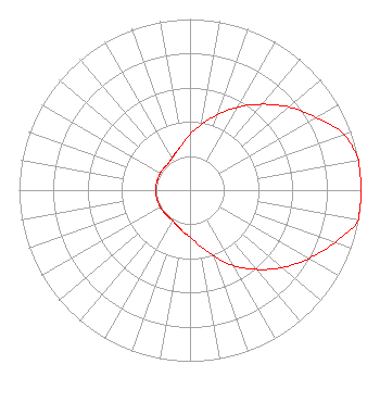 | ||||||||||||||||||
| Azimuth | Ratio | Azimuth | Ratio | Azimuth | Ratio | Azimuth | Ratio | ||||||||||||
| 0 | 0.325 | 10 | 0.390 | 20 | 0.470 | 30 | 0.560 | ||||||||||||
| 40 | 0.655 | 50 | 0.755 | 60 | 0.850 | 70 | 0.955 | ||||||||||||
| 80 | 1.000 | 90 | 1.000 | 100 | 1.000 | 110 | 0.900 | ||||||||||||
| 120 | 0.800 | 130 | 0.705 | 140 | 0.605 | 150 | 0.510 | ||||||||||||
| 160 | 0.410 | 170 | 0.330 | 180 | 0.275 | 190 | 0.245 | ||||||||||||
| 200 | 0.220 | 210 | 0.205 | 220 | 0.200 | 230 | 0.200 | ||||||||||||
| 240 | 0.200 | 250 | 0.200 | 260 | 0.200 | 270 | 0.200 | ||||||||||||
| 280 | 0.200 | 290 | 0.200 | 300 | 0.200 | 310 | 0.200 | ||||||||||||
| 320 | 0.200 | 330 | 0.215 | 340 | 0.235 | 350 | 0.270 | ||||||||||||
Structure Registration Number 1031769 Structure Type: TOWER Registered To: SummitMedia, LLC Structure Address: Palikea Ridge 4 Km Se Palihua Honolulu, HI County Name: Honolulu County ASR Issued: 05/16/2013 Date Built: 01/01/1991 Site Elevation: 701 m (2300 ft.) Structure Height: 41 m (135 ft.) Height Overall: 73 m (240 ft.) Overall Height AMSL: 774 m (2539 ft.) FAA Determination: 04/03/1991 FAA Study #: 91-AWP-003-OE FAA Circular #: 70/7460-1G Paint & Light FAA Chapters: 3, 4, 5, 9 21-23-40.0 N 158-05-51.0 W (NAD 83) 21-23-51.4 N 158-06-00.9 W (Converted to NAD 27) |
5700 West Oaks Boulevard Rocklin, CA 95765 Phone: 916-251-1600 Not-for-Profit | Date: 07/15/2015 Application Certifier EDUCATIONAL MEDIA FOUNDATION 5700 West Oaks Blvd Rocklin, CA 95765 Applicant STEPHEN WILDE 5700 West Oaks Blvd Rocklin, CA 95765 BROADCAST ENGINEER MARY N. O'CONNOR Educational Media Foundation | |||||||||||||||||