
FCCInfo.com
A Service of Cavell, Mertz & Associates, Inc.
(855) FCC-INFO
|
|
|
|
|
||||||||||||||||
|
|
K212BF Channel: 212D 90.3 MHz Eugene, Oregon Service: FX - A translator or application for a translator. Facility ID: 18844 Fac. Service: FX Programming Delivery Method: Unspecified Status: License Application Accepted: 09/22/2009 Application Granted: 09/23/2009 File Number: BMLFT-20090922ABA License Expires: 00/00/0000 Prefix Type: This is a modification of license for a translator Application Type: Minor Modification FCC Website Links: LMS Facility Details This Application CDBS Application Other K212BF Applications Other K212BF Applications in CDBS Including Superseded Applications Mailing Address Correspondence for K212BF Correspondence related to application BMLFT-20090922ABA Service Contour - Open Street Map or USGS Map (60 dBu) Service Contour - KML / Google Earth (60 dBu) Class: D, A Noncommercial educational operating with no more than 10W Site Location: 44-00-07.4 N 123-06-54.3 W (NAD 83) Site Location: 44-00-08.0 N 123-06-50.0 W (Converted to NAD 27) Effective Radiated Power: 0 kW Horiz. ; 0.023 kW Vert. Transmitter Output Power: 0.032 kW Antenna Center HAAT: 249 m Horiz.; 0 m Vert. Antenna Center AMSL: 0 m Horiz.; 446 m Vert. Antenna Center HAG: 0 m Horiz.; 50 m Vert. Calculated Site Elevation: m. Height Overall*: 113 m (371 ft.) (* As Filed In This Application, may differ from ASR Data, Below.) Directional Antenna Antenna Make/Model: None Antenna ID: 16166 Polarization:
| ||||||||||||||||||
| Antenna Data for Antenna Id: 16166 K212BF FX File: BMLFT-20090922ABA None - Service: FX Pattern and Field Values Include a 330° Clockwise Rotation | 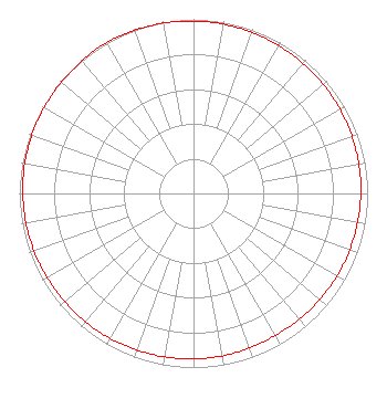 | ||||||||||||||||||
| Azimuth | Ratio | Azimuth | Ratio | Azimuth | Ratio | Azimuth | Ratio | ||||||||||||
| 0 | 0.990 | 10 | 0.987 | 20 | 0.984 | 30 | 0.980 | ||||||||||||
| 40 | 0.977 | 50 | 0.974 | 60 | 0.970 | 70 | 0.967 | ||||||||||||
| 80 | 0.964 | 90 | 0.961 | 100 | 0.957 | 110 | 0.954 | ||||||||||||
| 120 | 0.951 | 130 | 0.948 | 140 | 0.944 | 150 | 0.941 | ||||||||||||
| 160 | 0.944 | 170 | 0.948 | 180 | 0.951 | 190 | 0.954 | ||||||||||||
| 200 | 0.957 | 210 | 0.961 | 220 | 0.964 | 230 | 0.967 | ||||||||||||
| 240 | 0.970 | 250 | 0.974 | 260 | 0.977 | 270 | 0.980 | ||||||||||||
| 280 | 0.984 | 290 | 0.987 | 300 | 0.990 | 310 | 0.993 | ||||||||||||
| 320 | 0.997 | 330 | 1.000 | 340 | 0.997 | 350 | 0.993 | ||||||||||||
Structure Registration Number 1035780 [ASR Heights Differ from K212BF Application] Structure Type: LTOWER Registered To: American Towers LLC Structure Address: Or1001(a) - 4555 Blanton Rd Eugene, OR County Name: Lane County ASR Issued: 10/20/2014 Date Built: 06/18/1991 Site Elevation: 394.7 m (1295 ft.) Structure Height: 113.7 m (373 ft.) Height Overall: 113.7 m (373 ft.) Overall Height AMSL: 508.4 m (1668 ft.) FAA Determination: 03/12/2012 FAA Study #: 2012-ANM-512-OE Paint & Light FAA Chapters: NONE PRIOR STUDY 2007-ANM-102-OE 44-00-07.0 N 123-06-54.0 W (NAD 83) 44-00-07.6 N 123-06-49.7 W (Converted to NAD 27) |
5700 West Oaks Blvd Rocklin, CA 95765 Phone: 916-251-1600 | Date: 09/22/2009 Application Certifier EDUCATIONAL MEDIA FOUNDATION 5700 West Oaks Blvd Rocklin, CA 95765 Applicant KAREN A. ROSS, ESQ Davis Wright Tremaine Llp 1919 Pennslyvania Ave., Nw Suite 200 Washington, DC 20006 SAM WALLINGTON 5700 West Oaks Blvd Rocklin, CA 95765 VP OF ENGINEERING | |||||||||||||||||