
FCCInfo.com
A Service of Cavell, Mertz & Associates, Inc.
(855) FCC-INFO
|
|
WQAI from 11/11/2005 WQAI from 03/19/1998 |
|
|
||||||||||||||||
|
|
WQAI Channel: 208C1 89.5 MHz Thomson, Georgia Service: FM - A full-service FM station or application. Facility ID: 90293 Fac. Service: FM Status: License Application Accepted: 04/16/2015 Application Granted: 04/23/2015 File Number: BLED-20150416AAJ License Expires: 00/00/0000 Prefix Type: This is a license for a noncommercial educational FM station Application Type: License To Cover FCC Website Links: LMS Facility Details This Application CDBS Application Other WQAI Applications Other WQAI Applications in CDBS Including Superseded Applications Mailing Address Correspondence for WQAI Correspondence related to application BLED-20150416AAJ Service Contour - Open Street Map or USGS Map (60 dBu) Service Contour - KML / Google Earth (60 dBu) Public Inspection Files Facility Type: NON-COMMERCIAL EDUC. FM Class: C1, A Zone II station; with 50kW-100kW ERP and a class contour distance 52km-72km Site Location: 33-44-32.5 N 82-31-16.5 W (NAD 83) Site Location: 33-44-32.0 N 82-31-17.0 W (Converted to NAD 27) Effective Radiated Power: 0.063 kW Horiz. ; 63 kW Vert. Transmitter Output Power: 4.575 kW Antenna Center HAAT: 145 m (476 ft.) Antenna Center AMSL: 275 m (902 ft.) Antenna Center HAG: 46 m (151 ft.) Calculated Site Elevation: 229 m. (751 ft.) Height Overall*: 91 m (299 ft.) (* As Filed In This Application, may differ from ASR Data, Below.) Directional Antenna Antenna Make/Model: Jampro JMEP-4 DA, 4 section, 1 wavelength spaced Antenna ID: 120370 Polarization:
| ||||||||||||||||||
| Antenna Data for Antenna Id: 120370 WQAI FM File: BLED-20150416AAJ Jampro - JMEP-4 DA, 4 section, 1 wavelength spaced Service: FM | 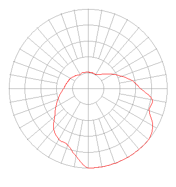 | ||||||||||||||||||
| Azimuth | Ratio | Azimuth | Ratio | Azimuth | Ratio | Azimuth | Ratio | ||||||||||||
| 0 | 0.204 | 10 | 0.204 | 20 | 0.204 | 30 | 0.202 | ||||||||||||
| 40 | 0.226 | 50 | 0.285 | 60 | 0.358 | 70 | 0.451 | ||||||||||||
| 80 | 0.568 | 90 | 0.663 | 100 | 0.823 | 110 | 0.823 | ||||||||||||
| 120 | 0.944 | 130 | 1.000 | 140 | 1.000 | 150 | 1.000 | ||||||||||||
| 160 | 1.000 | 170 | 1.000 | 180 | 1.000 | 190 | 0.866 | ||||||||||||
| 200 | 0.754 | 210 | 0.737 | 220 | 0.672 | 230 | 0.549 | ||||||||||||
| 240 | 0.469 | 250 | 0.404 | 260 | 0.350 | 270 | 0.307 | ||||||||||||
| 280 | 0.284 | 290 | 0.267 | 300 | 0.254 | 310 | 0.233 | ||||||||||||
| 320 | 0.217 | 330 | 0.201 | 340 | 0.212 | 350 | 0.206 | ||||||||||||
Structure Registration Number 1207199 Structure Type: TOWER Registered To: Lincoln, County of OES Structure Address: Atop Graves Mountain 5.6km West Of Ga Hwy 378 Lincolnton, GA County Name: Lincoln County ASR Issued: 12/07/1999 Date Built: 01/02/1983 Site Elevation: 228.6 m (750 ft.) Structure Height: 90 m (295 ft.) Height Overall: 91.1 m (299 ft.) Overall Height AMSL: 319.7 m (1049 ft.) FAA Determination: 01/01/1983 FAA Study #: 83-ASO-190-OE FAA Circular #: 70/7460-1F Paint & Light FAA Chapters: 3, 4, 5, 9 33-44-32.4 N 82-31-16.4 W (NAD 83) 33-44-31.9 N 82-31-16.9 W (Converted to NAD 27) |
5700 West Oaks Boulevard Rocklin, CA 95765 Phone: 916-251-1600 Not-for-Profit | Date: 04/16/2015 Application Certifier EDUCATIONAL MEDIA FOUNDATION 5700 West Oaks Blvd Rocklin, CA 95765 Applicant STEPHEN WILDE 5700 West Oaks Blvd Rocklin, CA 95765 BROADCAST ENGINEER MARY N. O'CONNOR Wilkinson Barker Knauer, Llp | |||||||||||||||||