
FCCInfo.com
A Service of Cavell, Mertz & Associates, Inc.
(855) FCC-INFO
|
|
WMXD from 12/28/1987 WMXD from 05/15/1986 |
|
|
||||||||||||||||
|
|
WMXD Channel: 222B 92.3 MHz Detroit, Michigan Service: FM - A full-service FM station or application. Facility ID: 59596 Fac. Service: FM Analog & Digital Status: License 73.215 Station Application Accepted: 03/03/1997 Application Granted: 02/04/1998 File Number: BLH-19970303KA License Expires: 00/00/0000 Prefix Type: This is a license for a commercial FM station Application Type: License To Cover FCC Website Links: LMS Facility Details This Application CDBS Application Other WMXD Applications Other WMXD Applications in CDBS Including Superseded Applications Mailing Address Correspondence for WMXD Correspondence related to application BLH-19970303KA Service Contour - Open Street Map or USGS Map (54 dBu) Service Contour - KML / Google Earth (54 dBu) Public Inspection Files History Cards for WMXD Facility Type: FM STATION Class: B, A Zone I or I-A station; with 25kW-50kW ERP and a class contour distance 39km-52km Site Location: 42-19-55.1 N 83-02-41.7 W (NAD 83) Site Location: 42-19-55.0 N 83-02-42.0 W (Converted to NAD 27) Effective Radiated Power: 45 kW Antenna Center HAAT: 146 m (479 ft.) Antenna Center AMSL: 331 m (1086 ft.) Antenna Center HAG: 149 m (489 ft.) Calculated Site Elevation: 182 m. (597 ft.) Height Overall*: 176 m (577 ft.) (* As Filed In This Application, may differ from ASR Data, Below.) Directional Antenna Antenna Make/Model: Oddball; usually designed by Applicant ODD920707II Antenna ID: 14385 Polarization: | ||||||||||||||||||
| Antenna Data for Antenna Id: 14385 WMXD FM File: BLH-19970303KA Oddball; usually designed by Applicant - ODD920707II Service: FM | 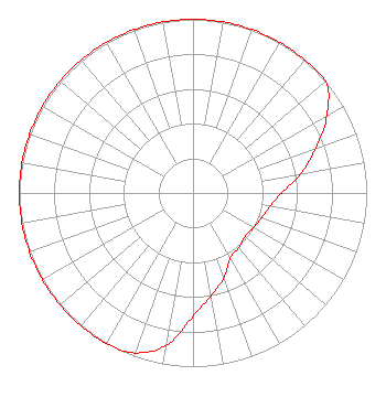 | ||||||||||||||||||
| Azimuth | Ratio | Azimuth | Ratio | Azimuth | Ratio | Azimuth | Ratio | ||||||||||||
| 0 | 1.000 | 10 | 1.000 | 20 | 1.000 | 30 | 1.000 | ||||||||||||
| 40 | 1.000 | 50 | 1.000 | 60 | 0.890 | 70 | 0.750 | ||||||||||||
| 80 | 0.630 | 90 | 0.510 | 100 | 0.450 | 110 | 0.420 | ||||||||||||
| 120 | 0.400 | 130 | 0.390 | 140 | 0.410 | 150 | 0.430 | ||||||||||||
| 160 | 0.520 | 170 | 0.600 | 180 | 0.710 | 190 | 0.890 | ||||||||||||
| 200 | 0.980 | 210 | 1.000 | 220 | 1.000 | 230 | 1.000 | ||||||||||||
| 240 | 1.000 | 250 | 1.000 | 260 | 1.000 | 270 | 1.000 | ||||||||||||
| 280 | 1.000 | 290 | 1.000 | 300 | 1.000 | 310 | 1.000 | ||||||||||||
| 320 | 1.000 | 330 | 1.000 | 340 | 1.000 | 350 | 1.000 | ||||||||||||
Structure Registration Number 1007645 Structure Type: BMAST Registered To: ASSOCIATES LIMITED MICHIGAN PARTNERSHIP DBA = CADILLAC TOWER Structure Address: 65 Cadillac Sq Detroit, MI County Name: Wayne County ASR Issued: 01/28/1997 Date Built: 01/01/1972 Site Elevation: 182 m (597 ft.) Structure Height: 172.2 m (565 ft.) Height Overall: 176.2 m (578 ft.) Overall Height AMSL: 358.2 m (1175 ft.) FAA Determination: 11/04/1996 FAA Study #: 96-AGL-3580-OE Paint & Light FAA Chapters: 1, 3, 4, 13, 21 RED LIGHTS/PAINT 42-19-55.0 N 83-02-42.0 W (NAD 83) 42-19-54.9 N 83-02-42.3 W (Converted to NAD 27) |
7136 S. Yale Avenue Suite 501 Tulsa, OK 74136 Phone: 918-664-4581 Limited Liability Company | Date: 03/03/1997 Application Certifier CHANCELLOR MEDIA RADIO LICENSES, LLC Chancellor Media Radio Licenses, L.l.c. Penobscot Bldg. 645 Gris Suite 633 Detroit, MI 48226 Applicant | |||||||||||||||||