
FCCInfo.com
A Service of Cavell, Mertz & Associates, Inc.
(855) FCC-INFO
|
|
K219LL from 08/18/2004 |
|
|
||||||||||||||||
|
|
K219LL Channel: 219D 91.7 MHz Chualar, California Service: FX - A translator or application for a translator. Facility ID: 152139 Fac. Service: FX Programming Delivery Method: Unspecified Status: License Application Accepted: 05/06/2011 Application Granted: 06/21/2011 File Number: BLFT-20110506ABG License Expires: 00/00/0000 Prefix Type: This is a license for a translator Application Type: License To Cover FCC Website Links: LMS Facility Details This Application CDBS Application Other K219LL Applications Other K219LL Applications in CDBS Including Superseded Applications Mailing Address Correspondence for K219LL Correspondence related to application BLFT-20110506ABG Service Contour - Open Street Map or USGS Map (60 dBu) Service Contour - KML / Google Earth (60 dBu) Class: D, A Noncommercial educational operating with no more than 10W Site Location: 36-45-22.9 N 121-30-08.8 W (NAD 83) Site Location: 36-45-23.0 N 121-30-05.0 W (Converted to NAD 27) Effective Radiated Power: 0.003 kW Horiz. ; 0.008 kW Vert. Transmitter Output Power: 0.012 kW Antenna Center HAAT: 656 m Horiz.; 0 m Vert. Antenna Center AMSL: 946 m (3104 ft.) Antenna Center HAG: 8 m (26 ft.) Site Elevation: 938 m. (3077 ft.) Height Overall*: 122 m (400 ft.) (* As Filed In This Application, may differ from ASR Data, Below.) Directional Antenna Antenna Make/Model: None Antenna ID: 31326 Polarization:
| ||||||||||||||||||
| Antenna Data for Antenna Id: 31326 K219LL FX File: BLFT-20110506ABG None - Service: FX Pattern and Field Values Include a 95° Clockwise Rotation | 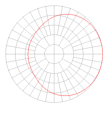 | ||||||||||||||||||
| Azimuth | Ratio | Azimuth | Ratio | Azimuth | Ratio | Azimuth | Ratio | ||||||||||||
| 5 | 0.792 | 15 | 0.845 | 25 | 0.892 | 35 | 0.929 | ||||||||||||
| 45 | 0.956 | 55 | 0.975 | 65 | 0.987 | 75 | 0.995 | ||||||||||||
| 85 | 0.999 | 95 | 1.000 | 105 | 0.999 | 115 | 0.995 | ||||||||||||
| 125 | 0.987 | 135 | 0.975 | 145 | 0.956 | 155 | 0.929 | ||||||||||||
| 165 | 0.892 | 175 | 0.845 | 185 | 0.792 | 195 | 0.735 | ||||||||||||
| 205 | 0.679 | 215 | 0.630 | 225 | 0.592 | 235 | 0.566 | ||||||||||||
| 245 | 0.549 | 255 | 0.540 | 265 | 0.535 | 275 | 0.534 | ||||||||||||
| 285 | 0.535 | 295 | 0.540 | 305 | 0.549 | 315 | 0.566 | ||||||||||||
| 325 | 0.592 | 335 | 0.630 | 345 | 0.679 | 355 | 0.735 | ||||||||||||
Structure Registration Number 1215158 Structure Type: LTOWER Registered To: Hearst Stations Inc. Structure Address: Fremont Peak, Approximatley 16 Km Northeast Of Salinas San Juan Bautis, CA County Name: Monterey County ASR Issued: 11/22/2016 Date Built: 12/05/2002 Site Elevation: 937.8 m (3077 ft.) Structure Height: 121.6 m (399 ft.) Height Overall: 122.5 m (402 ft.) Overall Height AMSL: 1060.3 m (3479 ft.) FAA Determination: 03/19/1999 FAA Study #: 99-AWP-0164-OE FAA Circular #: 70/7460-1J Paint & Light FAA Chapters: 3, 4, 5, 13 36-45-22.8 N 121-30-08.7 W (NAD 83) 36-45-22.9 N 121-30-04.9 W (Converted to NAD 27) |
3185 Highland Drive Suite 13 Las Vegas, NV 89109 Phone: 702-731-5588 Private Not-for-Profit Educational Institution | Date: 05/06/2011 Application Certifier ONE MINISTRIES, INC. P.o. Box 1118 Santa Rosa, CA 95402 Applicant JAMES L. OYSTER Law Offices Of James L. Oyster 108 Oyster Lane Castleton, VA 22716-2839 KEITH LEITCH P.o. Box 1118 Santa Rosa, CA 95402 ENGINEER | |||||||||||||||||