
FCCInfo.com
A Service of Cavell, Mertz & Associates, Inc.
(855) FCC-INFO
|
|
WEHM from 07/11/2003 WEHM from 04/30/2003 WEHM from 07/24/2001 |
|
|
||||||||||||||||
|
|
WEHM Channel: 225A 92.9 MHz Manorville, New York Service: FM - A full-service FM station or application. Facility ID: 52059 Fac. Service: FM Status: License 73.215 Station Application Accepted: 06/10/2008 Application Granted: 06/24/2008 File Number: BLH-20080610ACO License Expires: 00/00/0000 Prefix Type: This is a license for a commercial FM station Application Type: License To Cover FCC Website Links: LMS Facility Details This Application CDBS Application Other WEHM Applications Other WEHM Applications in CDBS Including Superseded Applications Mailing Address Correspondence for WEHM Correspondence related to application BLH-20080610ACO Service Contour - Open Street Map or USGS Map (60 dBu) Service Contour - KML / Google Earth (60 dBu) Public Inspection Files Facility Type: FM STATION Class: A, A Zone I; I-A; or II station; with 0.1kW-6kW ERP and a class contour distance <=28km Site Location: 40-51-18.4 N 72-46-09.4 W (NAD 83) Site Location: 40-51-18.0 N 72-46-11.0 W (Converted to NAD 27) Effective Radiated Power: 3.1 kW Transmitter Output Power: 3.85 kW Antenna Center HAAT: 141 m (463 ft.) Antenna Center AMSL: 157 m (515 ft.) Antenna Center HAG: 82 m (269 ft.) Calculated Site Elevation: 75 m. (246 ft.) Height Overall*: 155.4 m (510 ft.) (* As Filed In This Application, may differ from ASR Data, Below.) Directional Antenna Antenna Make/Model: Shivley 6014-1/3-DA Antenna ID: 78581 Polarization: | ||||||||||||||||||
| Antenna Data for Antenna Id: 78581 WEHM FM File: BLH-20080610ACO Shivley - 6014-1/3-DA Service: FM | 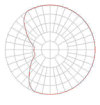 | ||||||||||||||||||
| Azimuth | Ratio | Azimuth | Ratio | Azimuth | Ratio | Azimuth | Ratio | ||||||||||||
| 0 | 1.000 | 10 | 1.000 | 20 | 1.000 | 30 | 1.000 | ||||||||||||
| 40 | 1.000 | 50 | 1.000 | 60 | 1.000 | 70 | 1.000 | ||||||||||||
| 80 | 1.000 | 90 | 1.000 | 100 | 1.000 | 110 | 1.000 | ||||||||||||
| 120 | 1.000 | 130 | 1.000 | 140 | 1.000 | 150 | 1.000 | ||||||||||||
| 160 | 1.000 | 170 | 1.000 | 180 | 1.000 | 190 | 1.000 | ||||||||||||
| 200 | 1.000 | 210 | 0.902 | 220 | 0.717 | 230 | 0.569 | ||||||||||||
| 240 | 0.452 | 250 | 0.359 | 260 | 0.359 | 270 | 0.359 | ||||||||||||
| 280 | 0.359 | 290 | 0.452 | 300 | 0.567 | 310 | 0.713 | ||||||||||||
| 320 | 0.898 | 330 | 1.000 | 340 | 1.000 | 350 | 1.000 | ||||||||||||
Structure Registration Number 1004116 [ASR Heights Differ from WEHM Application] Structure Type: GTOWER Registered To: SBA Properties, LLC Structure Address: Cr111 & Eastport Manor Road Manorville, NY County Name: Suffolk County ASR Issued: 08/22/2023 Date Built: 07/01/1998 Site Elevation: 74.3 m (244 ft.) Structure Height: 155.4 m (510 ft.) Height Overall: 155.4 m (510 ft.) Overall Height AMSL: 229.7 m (754 ft.) FAA Determination: 03/14/2023 FAA Study #: 2022-AEA-242-OE FAA Circular #: 70/7460-1K Paint & Light FAA Chapters: 4, 7, 12 OM&L to remain the same as prior study = 24-HR HI-STROBES 40-51-18.2 N 72-46-09.0 W (NAD 83) 40-51-17.8 N 72-46-10.6 W (Converted to NAD 27) |
760 Montauk Highway Water Mill, NY 11976 Phone: 631-267-7800 Limited Liability Company | Date: 06/10/2008 Application Certifier AAA LICENSING LLC 1110 Central Avenue Pawtucket, RI 02861-2262 Applicant ROBERT M. SMITH JR. R.m. Smith Associates 4267 Nw Federal Highway #120 Jensen Beach, FL 34957 TECHNICAL CONSULTANT PETER TANNENWALD Fletcher, Heald & Hildredth, P.l.c. | |||||||||||||||||