
FCCInfo.com
A Service of Cavell, Mertz & Associates, Inc.
(855) FCC-INFO
|
|
W284AQ from 12/12/1994 |
|
|
||||||||||||||||
|
|
W284AQ Channel: 284D 104.7 MHz Hackettstown, New Jersey Service: FX - A translator or application for a translator. Facility ID: 54698 Fac. Service: FX Programming Delivery Method: Unspecified Status: License Application Accepted: 03/09/2017 Application Granted: 03/22/2017 File Number: BLFT-20170309ABK License Expires: 00/00/0000 Prefix Type: This is a license for a translator Application Type: License To Cover FCC Website Links: LMS Facility Details This Application CDBS Application Other W284AQ Applications Other W284AQ Applications in CDBS Including Superseded Applications Mailing Address Correspondence for W284AQ Correspondence related to application BLFT-20170309ABK Service Contour - Open Street Map or USGS Map (60 dBu) Service Contour - KML / Google Earth (60 dBu) Class: D, A Noncommercial educational operating with no more than 10W Site Location: 40-51-19.4 N 74-46-40.6 W (NAD 83) Site Location: 40-51-19.0 N 74-46-42.0 W (Converted to NAD 27) Effective Radiated Power: 0.25 kW Transmitter Output Power: 0.29 kW Antenna Center HAAT: 0 m Antenna Center AMSL: 392 m (1286 ft.) Antenna Center HAG: 63 m (207 ft.) Site Elevation: 329 m. (1079 ft.) Height Overall*: 66 m (217 ft.) (* As Filed In This Application, may differ from ASR Data, Below.) Directional Antenna Antenna Make/Model: None Antenna ID: 126635 Polarization:
| ||||||||||||||||||
| Antenna Data for Antenna Id: 126635 W284AQ FX File: BLFT-20170309ABK None - Service: FX | 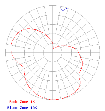 | ||||||||||||||||||
| Azimuth | Ratio | Azimuth | Ratio | Azimuth | Ratio | Azimuth | Ratio | ||||||||||||
| 0 | 0.200 | 10 | 0.100 | 20 | 0.100 | 30 | 0.115 | ||||||||||||
| 40 | 0.155 | 50 | 0.215 | 60 | 0.290 | 70 | 0.380 | ||||||||||||
| 80 | 0.480 | 90 | 0.550 | 100 | 0.600 | 110 | 0.680 | ||||||||||||
| 120 | 0.700 | 130 | 0.730 | 140 | 0.902 | 150 | 0.960 | ||||||||||||
| 160 | 0.980 | 170 | 1.000 | 180 | 1.000 | 190 | 0.980 | ||||||||||||
| 200 | 0.950 | 210 | 0.905 | 220 | 0.845 | 230 | 0.770 | ||||||||||||
| 240 | 0.680 | 250 | 0.730 | 260 | 0.810 | 270 | 0.870 | ||||||||||||
| 280 | 0.890 | 290 | 0.870 | 300 | 0.835 | 310 | 0.768 | ||||||||||||
| 320 | 0.646 | 330 | 0.510 | 340 | 0.390 | 350 | 0.276 | ||||||||||||
Structure Registration Number 1202687 Structure Type: TOWER Registered To: Budd Lake Tower, LLC Structure Address: 429 Sand Shore Road Mt. Olive Township, NJ County Name: Morris County ASR Issued: 02/24/2015 Date Built: 09/08/2000 Site Elevation: 328.9 m (1079 ft.) Structure Height: 60 m (197 ft.) Height Overall: 66.4 m (218 ft.) Overall Height AMSL: 395.3 m (1297 ft.) FAA Determination: 04/22/2011 FAA Study #: 2011-AEA-595-OE FAA Circular #: 70/7460-1K Paint & Light FAA Chapters: 4, 6, 12 PRIOR STUDY 1999-AEA-168-OE 40-51-19.7 N 74-46-40.8 W (NAD 83) 40-51-19.3 N 74-46-42.2 W (Converted to NAD 27) |
P.o. Box 1000 Hackettstown, NJ 07840 Phone: 908-850-1000 | Date: 03/09/2017 Application Certifier WRNJ RADIO, INC. P. O. Box 1000 Hackettstown, NJ 07840 Applicant CLARENCE M. BEVERAGE Communications Technologies, Inc. P. O. Box 1130 Marlton, NJ 08053 BROADCAST ENGINEERING CONSULTANT MARK N. LIPP Wiley Rein Llp 1776 K Street, Nw Washington, DC 20006 | |||||||||||||||||