
FCCInfo.com
A Service of Cavell, Mertz & Associates, Inc.
(855) FCC-INFO
|
|
|
|
|
||||||||||||||||
|
|
W260BG Channel: 260D 99.9 MHz Lexington, North Carolina Service: FX - A translator or application for a translator. Facility ID: 148853 Fac. Service: FX Programming Delivery Method: Unspecified Status: License Application Accepted: 08/16/2018 Application Granted: 08/27/2018 File Number: BLFT-20180816AAH License Expires: 00/00/0000 Prefix Type: This is a license for a translator Application Type: License To Cover FCC Website Links: LMS Facility Details This Application CDBS Application Other W260BG Applications Other W260BG Applications in CDBS Including Superseded Applications Mailing Address Correspondence for W260BG Correspondence related to application BLFT-20180816AAH Service Contour - Open Street Map or USGS Map (60 dBu) Service Contour - KML / Google Earth (60 dBu) Class: D, A Noncommercial educational operating with no more than 10W Site Location: 35-55-02.5 N 80-17-37.2 W (NAD 83) Site Location: 35-55-02.0 N 80-17-38.0 W (Converted to NAD 27) Effective Radiated Power: 0.25 kW Transmitter Output Power: 0.463 kW Antenna Center HAAT: 0 m Antenna Center AMSL: 489 m (1604 ft.) Antenna Center HAG: 256 m (840 ft.) Site Elevation: 233 m. (764 ft.) Height Overall*: 320 m (1050 ft.) (* As Filed In This Application, may differ from ASR Data, Below.) Directional Antenna Antenna Make/Model: None Antenna ID: 120504 Polarization:
| ||||||||||||||||||
| Antenna Data for Antenna Id: 120504 W260BG FX File: BLFT-20180816AAH None - Service: FX | 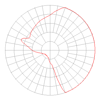 | ||||||||||||||||||
| Azimuth | Ratio | Azimuth | Ratio | Azimuth | Ratio | Azimuth | Ratio | ||||||||||||
| 0 | 0.775 | 10 | 0.894 | 20 | 1.000 | 30 | 1.000 | ||||||||||||
| 40 | 1.000 | 50 | 1.000 | 60 | 1.000 | 70 | 1.000 | ||||||||||||
| 80 | 1.000 | 90 | 1.000 | 100 | 1.000 | 110 | 1.000 | ||||||||||||
| 120 | 1.000 | 130 | 1.000 | 140 | 1.000 | 150 | 1.000 | ||||||||||||
| 160 | 1.000 | 170 | 0.400 | 180 | 0.280 | 190 | 0.180 | ||||||||||||
| 200 | 0.160 | 210 | 0.141 | 220 | 0.141 | 230 | 0.141 | ||||||||||||
| 240 | 0.167 | 250 | 0.200 | 260 | 0.283 | 270 | 0.400 | ||||||||||||
| 280 | 0.510 | 290 | 0.680 | 300 | 0.540 | 310 | 0.566 | ||||||||||||
| 320 | 0.600 | 330 | 0.632 | 340 | 0.680 | 350 | 0.721 | ||||||||||||
Structure Registration Number 1006732 Structure Type: TOWER Registered To: DAVIDSON INVESTMENTS LLC Structure Address: O L Evans Farm Rd Arcadia, NC County Name: Davidson County ASR Issued: 01/15/1997 Date Built: 01/01/1988 Site Elevation: 233 m (764 ft.) Structure Height: 318.5 m (1045 ft.) Height Overall: 320 m (1050 ft.) Overall Height AMSL: 553 m (1814 ft.) FAA Determination: 11/23/1988 FAA Study #: 87-ASO-2208-OE FAA Circular #: 70/7460-1G Paint & Light FAA Chapters: 4, 6, 9 35-55-02.0 N 80-17-37.0 W (NAD 83) 35-55-01.5 N 80-17-37.8 W (Converted to NAD 27) |
5700 West Oaks Blvd. Rocklin, CA 95765 Phone: 916-251-1600 Not-for-Profit | Date: 08/16/2018 Application Certifier DAVIDSON COUNTY BROADCASTING CO., INC. 200 Radio Drive Lexington, NC 27292 Applicant R. STUART GRAHAM Graham Brock, Inc. P. O. Box 24466 St. Simons Island, GA 31522-7466 TECHNICAL CONSULTANT GARY S. SMITHWICK, ESQUIRE Smithwick & Belendiuk, P.c. 5028 Wisconsin Avenue, N.w. Suite 301 Washington, DC 20016 | |||||||||||||||||