
FCCInfo.com
A Service of Cavell, Mertz & Associates, Inc.
(855) FCC-INFO
|
|
|
|
|
||||||||||||||||
|
|
K286CH Channel: 286D 105.1 MHz Twin Falls, Idaho Service: FX - A translator or application for a translator. Facility ID: 151707 Fac. Service: FX Programming Delivery Method: Unspecified Status: License Application Accepted: 09/16/2019 Application Granted: 09/18/2019 File Number: BLFT-20190916ABE License Expires: 00/00/0000 Prefix Type: This is a license for a translator Application Type: License To Cover FCC Website Links: LMS Facility Details This Application CDBS Application Other K286CH Applications Other K286CH Applications in CDBS Including Superseded Applications Mailing Address Correspondence for K286CH Correspondence related to application BLFT-20190916ABE Service Contour - Open Street Map or USGS Map (60 dBu) Service Contour - KML / Google Earth (60 dBu) Class: D, A Noncommercial educational operating with no more than 10W Site Location: 42-33-44.7 N 114-32-37.1 W (NAD 83) Site Location: 42-33-45.0 N 114-32-34.0 W (Converted to NAD 27) Effective Radiated Power: 0.19 kW Transmitter Output Power: 0.739 kW Antenna Center HAAT: 0 m Antenna Center AMSL: 1233 m (4045 ft.) Antenna Center HAG: 99 m (325 ft.) Site Elevation: 1134 m. (3720 ft.) Height Overall*: 104 m (341 ft.) (* As Filed In This Application, may differ from ASR Data, Below.) Directional Antenna Antenna Make/Model: None Antenna ID: 134994 Polarization:
| ||||||||||||||||||
| Antenna Data for Antenna Id: 134994 K286CH FX File: BLFT-20190916ABE None - Service: FX | 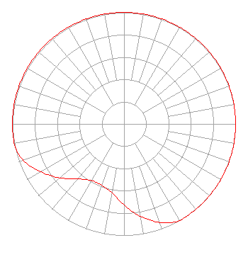 | ||||||||||||||||||
| Azimuth | Ratio | Azimuth | Ratio | Azimuth | Ratio | Azimuth | Ratio | ||||||||||||
| 0 | 1.000 | 10 | 1.000 | 20 | 1.000 | 30 | 1.000 | ||||||||||||
| 40 | 1.000 | 50 | 1.000 | 60 | 1.000 | 70 | 1.000 | ||||||||||||
| 80 | 1.000 | 90 | 1.000 | 100 | 1.000 | 110 | 1.000 | ||||||||||||
| 120 | 1.000 | 130 | 1.000 | 140 | 1.000 | 150 | 1.000 | ||||||||||||
| 160 | 0.940 | 170 | 0.840 | 180 | 0.728 | 190 | 0.625 | ||||||||||||
| 200 | 0.585 | 210 | 0.586 | 220 | 0.644 | 230 | 0.752 | ||||||||||||
| 240 | 0.860 | 250 | 0.960 | 260 | 1.000 | 270 | 1.000 | ||||||||||||
| 280 | 1.000 | 290 | 1.000 | 300 | 1.000 | 310 | 1.000 | ||||||||||||
| 320 | 1.000 | 330 | 1.000 | 340 | 1.000 | 350 | 1.000 | ||||||||||||
Structure Registration Number 1021395 [ASR Heights Differ from K286CH Application] Structure Type: TOWER Registered To: Iliad Media Boise, LLC Structure Address: 21361 U.s. Hwy. #30 Twin Falls, ID County Name: Twin Falls County ASR Issued: 01/16/2018 Date Built: 11/15/1996 Site Elevation: 1133.5 m (3719 ft.) Structure Height: 102.7 m (337 ft.) Height Overall: 103.6 m (340 ft.) Overall Height AMSL: 1237.1 m (4059 ft.) FAA Determination: 09/05/1997 FAA Study #: 97-ANM-0893-OE FAA Circular #: Paint & Light FAA Chapters: 1, 3, 12, 21 PREVIOUS STUDY #97-ANM-0753-OE. 42-33-45.0 N 114-32-37.0 W (NAD 83) 42-33-45.3 N 114-32-33.9 W (Converted to NAD 27) |
5660 East Franklin Rd. Suite 200 Nampa, ID 83687 Phone: 208-365-9966 Corporation | Date: 09/16/2019 Application Certifier ILIAD MEDIA TWIN FALLS, LLC 21369 Highway 30 Twin Falls, ID 83301 Applicant KATHLEEN VICTORY Fletcher Headl & Hildreth, Plc 1300 N. 17th Street Suite 1100 Arlington, VA 22209 IAN L. PERRY 21369 Highway 30 Twin Falls, ID 83301 REGIONAL DIRECTOR OF ENGINEERING | |||||||||||||||||