
FCCInfo.com
A Service of Cavell, Mertz & Associates, Inc.
(855) FCC-INFO
|
|
W237AT from 09/21/1988 W237AT from 12/10/1984 |
|
|
||||||||||||||||
|
|
W237AT Channel: 237D 95.3 MHz Richmond, Indiana Service: FX - A translator or application for a translator. Facility ID: 65509 Fac. Service: FX Programming Delivery Method: Unspecified Status: License Application Accepted: 11/14/2016 Application Granted: 11/25/2016 File Number: BLFT-20161114AAI License Expires: 00/00/0000 Prefix Type: This is a license for a translator Application Type: License To Cover FCC Website Links: LMS Facility Details This Application CDBS Application Other W237AT Applications Other W237AT Applications in CDBS Including Superseded Applications Mailing Address Correspondence for W237AT Correspondence related to application BLFT-20161114AAI Service Contour - Open Street Map or USGS Map (60 dBu) Service Contour - KML / Google Earth (60 dBu) Class: D, A Noncommercial educational operating with no more than 10W Site Location: 39-53-29.2 N 84-56-09.9 W (NAD 83) Site Location: 39-53-29.0 N 84-56-10.0 W (Converted to NAD 27) Effective Radiated Power: 0.25 kW Transmitter Output Power: 0.853 kW Antenna Center HAAT: 0 m Antenna Center AMSL: 446 m (1463 ft.) Antenna Center HAG: 114 m (374 ft.) Site Elevation: 332 m. (1089 ft.) Height Overall*: 150 m (492 ft.) (* As Filed In This Application, may differ from ASR Data, Below.) Directional Antenna Antenna Make/Model: None Antenna ID: 125786 Polarization:
| ||||||||||||||||||
| Antenna Data for Antenna Id: 125786 W237AT FX File: BLFT-20161114AAI None - Service: FX | 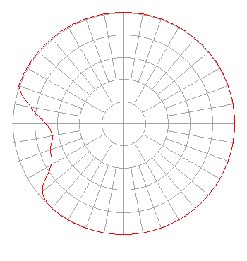 | ||||||||||||||||||
| Azimuth | Ratio | Azimuth | Ratio | Azimuth | Ratio | Azimuth | Ratio | ||||||||||||
| 0 | 1.000 | 10 | 1.000 | 20 | 1.000 | 30 | 1.000 | ||||||||||||
| 40 | 1.000 | 50 | 1.000 | 60 | 1.000 | 70 | 1.000 | ||||||||||||
| 80 | 1.000 | 90 | 1.000 | 100 | 1.000 | 110 | 1.000 | ||||||||||||
| 120 | 1.000 | 130 | 1.000 | 140 | 1.000 | 150 | 1.000 | ||||||||||||
| 160 | 1.000 | 170 | 1.000 | 180 | 1.000 | 190 | 1.000 | ||||||||||||
| 200 | 1.000 | 210 | 1.000 | 220 | 1.000 | 230 | 0.950 | ||||||||||||
| 240 | 0.750 | 250 | 0.700 | 260 | 0.650 | 270 | 0.700 | ||||||||||||
| 280 | 0.850 | 290 | 1.000 | 300 | 1.000 | 310 | 1.000 | ||||||||||||
| 320 | 1.000 | 330 | 1.000 | 340 | 1.000 | 350 | 1.000 | ||||||||||||
Structure Registration Number 1029152 Structure Type: TOWER Registered To: BREWER BROADCASTING CORPORATION Structure Address: 0.2 Mi North Of 2626 Tingler Road Richmond, IN County Name: Wayne County ASR Issued: 02/01/2011 Date Built: 03/22/1999 Site Elevation: 331.9 m (1089 ft.) Structure Height: 149.4 m (490 ft.) Height Overall: 150.3 m (493 ft.) Overall Height AMSL: 482.2 m (1582 ft.) FAA Determination: 01/25/2011 FAA Study #: 2010-AGL-6792-OE FAA Circular #: 70/7460-1J Paint & Light FAA Chapters: 3, 4, 5, 13 PRIOR STUDY 1997-AGL-6068-OE 39-53-28.7 N 84-56-09.4 W (NAD 83) 39-53-28.5 N 84-56-09.5 W (Converted to NAD 27) |
P.o. Box 1647 Richmond, IN 47375 Phone: 765-962-1595 | Date: 11/14/2016 Application Certifier BREWER BROADCASTING CORP. 2626 Tingler Road Richmond, IN 47374 Applicant JUSTIN W. ASHER Munn-reese P.o. Box 220 Coldwater, MI 49036-0220 TECHNICAL CONSULTANT DAVID D. OXENFORD Wilkinson Barker Knauer, Llp 1800 M Street, N.w. Suite 800n Washington, DC 20036 | |||||||||||||||||