
FCCInfo.com
A Service of Cavell, Mertz & Associates, Inc.
(855) FCC-INFO
|
|
WNJY from 06/27/2008 WNJY from 07/30/1999 |
|
|
||||||||||||||||
|
|
WNJY Channel: 207A 89.3 MHz Netcong, New Jersey Service: FM - A full-service FM station or application. Facility ID: 93964 Fac. Service: FM Status: License Application Accepted: 07/07/2008 Application Granted: 07/30/2008 File Number: BLED-20080707AEO License Expires: 00/00/0000 Prefix Type: This is a license for a noncommercial educational FM station Application Type: License To Cover FCC Website Links: LMS Facility Details This Application CDBS Application Other WNJY Applications Other WNJY Applications in CDBS Including Superseded Applications Mailing Address Correspondence for WNJY Correspondence related to application BLED-20080707AEO Service Contour - Open Street Map or USGS Map (60 dBu) Service Contour - KML / Google Earth (60 dBu) Public Inspection Files Facility Type: NON-COMMERCIAL EDUC. FM Class: A, A Zone I; I-A; or II station; with 0.1kW-6kW ERP and a class contour distance <=28km Site Location: 40-53-14.4 N 74-41-53.6 W (NAD 83) Site Location: 40-53-14.0 N 74-41-55.0 W (Converted to NAD 27) Effective Radiated Power: 0.001 kW Horiz. ; 0.52 kW Vert. Transmitter Output Power: 0.203 kW Antenna Center HAAT: 131 m (430 ft.) Antenna Center AMSL: 385 m (1263 ft.) Antenna Center HAG: 64 m (210 ft.) Calculated Site Elevation: 321 m. (1053 ft.) Height Overall*: 80 m (262 ft.) (* As Filed In This Application, may differ from ASR Data, Below.) Directional Antenna Antenna Make/Model: Scala 2-CA5-FM-VRM (SLANT) Antenna ID: 88028 Polarization: | ||||||||||||||||||
| Antenna Data for Antenna Id: 88028 WNJY FM File: BLED-20080707AEO Scala - 2-CA5-FM-VRM (SLANT) Service: FM | 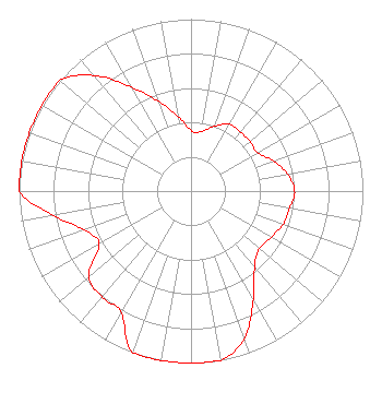 | ||||||||||||||||||
| Azimuth | Ratio | Azimuth | Ratio | Azimuth | Ratio | Azimuth | Ratio | ||||||||||||
| 0 | 0.351 | 10 | 0.351 | 20 | 0.403 | 30 | 0.449 | ||||||||||||
| 40 | 0.447 | 50 | 0.449 | 60 | 0.447 | 70 | 0.512 | ||||||||||||
| 80 | 0.569 | 90 | 0.603 | 100 | 0.582 | 110 | 0.569 | ||||||||||||
| 120 | 0.537 | 130 | 0.519 | 140 | 0.575 | 150 | 0.724 | ||||||||||||
| 160 | 0.910 | 170 | 1.000 | 180 | 1.000 | 190 | 1.000 | ||||||||||||
| 200 | 1.000 | 210 | 0.813 | 220 | 0.804 | 230 | 0.776 | ||||||||||||
| 240 | 0.617 | 250 | 0.661 | 260 | 0.813 | 270 | 1.000 | ||||||||||||
| 280 | 1.000 | 290 | 1.000 | 300 | 1.000 | 310 | 1.000 | ||||||||||||
| 320 | 0.878 | 330 | 0.698 | 340 | 0.555 | 350 | 0.442 | ||||||||||||
Structure Registration Number 1046972 Structure Type: TOWER Registered To: NEW JERSEY, STATE OF Structure Address: Nj State Police Rt 206 & Rt 80 Netcong, NJ County Name: Morris County ASR Issued: 06/14/2006 Date Built: 06/01/2006 Site Elevation: 321 m (1053 ft.) Structure Height: 76 m (249 ft.) Height Overall: 80 m (262 ft.) Overall Height AMSL: 401 m (1316 ft.) FAA Determination: 04/17/2006 FAA Study #: 2006-AEA-1414-OE FAA Circular #: 70/7460-1K Paint & Light FAA Chapters: 4, 6, 12 PRIOR STUDY 1998-AEA-2287-OE 40-53-14.0 N 74-41-54.0 W (NAD 83) 40-53-13.6 N 74-41-55.4 W (Converted to NAD 27) |
160 Varick Street New York, NY 10013 Phone: 646-829-4400 | Date: 07/07/2008 Application Certifier NEW JERSEY PUBLIC BROADCASTING AUTHORITY Po Box 777 Trenton, NJ 08625 Applicant CHARLES W. LOUGHERY 532 Ridge Road Telford, PA 18969 TECHNICAL CONSULTANT MALCOLM G. STEVENSON Schwartz, Woods & Miller | |||||||||||||||||