
FCCInfo.com
A Service of Cavell, Mertz & Associates, Inc.
(855) FCC-INFO
|
|
|
|  |
|
|||||||||||||||
|
|
WNEQ Channel: 212A 90.3 MHz Taylortown, New Jersey Service: FM - A full-service FM station or application. Facility ID: 175731 Fac. Service: FM Status: License Application Accepted: 09/12/2013 Application Granted: 09/17/2013 File Number: BLED-20130912AAJ License Expires: 00/00/0000 Prefix Type: This is a license for a noncommercial educational FM station Application Type: License To Cover FCC Website Links: LMS Facility Details This Application CDBS Application Other WNEQ Applications Other WNEQ Applications in CDBS Including Superseded Applications Mailing Address Correspondence for WNEQ Correspondence related to application BLED-20130912AAJ Service Contour - Open Street Map or USGS Map (60 dBu) Service Contour - KML / Google Earth (60 dBu) Public Inspection Files Facility Type: NON-COMMERCIAL EDUC. FM Class: A, A Zone I; I-A; or II station; with 0.1kW-6kW ERP and a class contour distance <=28km Site Location: 41-01-00.4 N 74-27-45.6 W (NAD 83) Site Location: 41-01-00.0 N 74-27-47.0 W (Converted to NAD 27) Effective Radiated Power: 0.06 kW Transmitter Output Power: 0.033 kW Antenna Center HAAT: 174 m (571 ft.) Antenna Center AMSL: 434 m (1424 ft.) Antenna Center HAG: 72 m (236 ft.) Calculated Site Elevation: 362 m. (1188 ft.) Height Overall*: 82 m (269 ft.) (* As Filed In This Application, may differ from ASR Data, Below.) Directional Antenna Antenna Make/Model: Shivley 6025-1/2-DA Antenna ID: 82731 Polarization:
| ||||||||||||||||||
| Antenna Data for Antenna Id: 82731 WNEQ FM File: BLED-20130912AAJ Shivley - 6025-1/2-DA Service: FM | 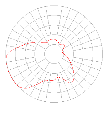 | ||||||||||||||||||
| Azimuth | Ratio | Azimuth | Ratio | Azimuth | Ratio | Azimuth | Ratio | ||||||||||||
| 0 | 0.305 | 10 | 0.281 | 20 | 0.261 | 30 | 0.208 | ||||||||||||
| 40 | 0.261 | 50 | 0.282 | 60 | 0.224 | 70 | 0.178 | ||||||||||||
| 80 | 0.178 | 90 | 0.203 | 100 | 0.256 | 110 | 0.322 | ||||||||||||
| 120 | 0.405 | 130 | 0.510 | 140 | 0.642 | 150 | 0.694 | ||||||||||||
| 160 | 0.552 | 170 | 0.489 | 180 | 0.541 | 190 | 0.562 | ||||||||||||
| 200 | 0.583 | 210 | 0.734 | 220 | 0.924 | 230 | 1.000 | ||||||||||||
| 240 | 1.000 | 250 | 1.000 | 260 | 1.000 | 270 | 0.954 | ||||||||||||
| 280 | 0.758 | 290 | 0.602 | 300 | 0.478 | 310 | 0.380 | ||||||||||||
| 320 | 0.302 | 330 | 0.277 | 340 | 0.299 | 350 | 0.305 | ||||||||||||
Structure Registration Number 1054662 [ASR Heights Differ from WNEQ Application] Structure Type: LTOWER Registered To: American Towers LLC Structure Address: Jacob's Ladder Rd, Box 211a ( 088084 ) Rockaway, NJ County Name: Morris County ASR Issued: 07/09/2013 Date Built: 06/16/2008 Site Elevation: 358.1 m (1175 ft.) Structure Height: 68.6 m (225 ft.) Height Overall: 75.9 m (249 ft.) Overall Height AMSL: 434 m (1424 ft.) FAA Determination: 07/08/2013 FAA Study #: 2013-AEA-3003-OE FAA Circular #: 70/7460-1K Paint & Light FAA Chapters: 4, 8, 12 PRIOR STUDY 2013-AEA-168-OE 41-01-00.3 N 74-27-45.1 W (NAD 83) 41-00-59.9 N 74-27-46.5 W (Converted to NAD 27) |
P.o. Box 1520 Olivebridge, NY 12461-1520 Phone: 845-657-6239 | Date: 09/12/2013 Application Certifier REDEEMER BROADCASTING, INC. P.o. Box 1520 Olivebridge, NY 12461-1520 Applicant ROBERT MOORE 1908 Sweetbriar Goshen, IN 46528 CONSULTING ENGINEER GREGG P. SKALL, ESQ. Womble Carlyle Sandridge & Rice, Pllc | |||||||||||||||||