
FCCInfo.com
A Service of Cavell, Mertz & Associates, Inc.
(855) FCC-INFO
|
|
KLBR from 01/26/1998 |
|  |
|
|||||||||||||||
|
|
KLBR Channel: 201C2 88.1 MHz Bend, Oregon Service: FM - A full-service FM station or application. Facility ID: 89855 Fac. Service: FM Analog & Digital Status: License Application Accepted: 10/12/2005 Application Granted: 02/28/2006 File Number: BLED-20051012ADB License Expires: 00/00/0000 Prefix Type: This is a license for a noncommercial educational FM station Application Type: License To Cover FCC Website Links: LMS Facility Details This Application CDBS Application Other KLBR Applications Other KLBR Applications in CDBS Including Superseded Applications Mailing Address Correspondence for KLBR Correspondence related to application BLED-20051012ADB Service Contour - Open Street Map or USGS Map (60 dBu) Service Contour - KML / Google Earth (60 dBu) Public Inspection Files Facility Type: NON-COMMERCIAL EDUC. FM Class: C2, A Zone II station; with 25kW-50kW ERP and a class contour distance 39km-52km Site Location: 44-02-48.4 N 121-31-54.1 W (NAD 83) Site Location: 44-02-49.0 N 121-31-50.0 W (Converted to NAD 27) Effective Radiated Power: 5 kW Transmitter Output Power: 2.9 kW Antenna Center HAAT: 259 m (850 ft.) Antenna Center AMSL: 1827 m (5994 ft.) Antenna Center HAG: 43 m (141 ft.) Site Elevation: 1784 m. (5853 ft.) Height Overall*: 99 m (325 ft.) (* As Filed In This Application, may differ from ASR Data, Below.) Directional Antenna Antenna Make/Model: Shivley 6810-2R-DA, two sections Antenna ID: 69728 Polarization:
| ||||||||||||||||||
| Antenna Data for Antenna Id: 69728 KLBR FM File: BLED-20051012ADB Shivley - 6810-2R-DA, two sections Service: FM | 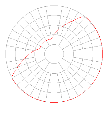 | ||||||||||||||||||
| Azimuth | Ratio | Azimuth | Ratio | Azimuth | Ratio | Azimuth | Ratio | ||||||||||||
| 0 | 0.398 | 10 | 0.501 | 20 | 0.631 | 30 | 0.794 | ||||||||||||
| 40 | 1.000 | 50 | 1.000 | 60 | 1.000 | 70 | 1.000 | ||||||||||||
| 80 | 1.000 | 90 | 1.000 | 100 | 1.000 | 110 | 1.000 | ||||||||||||
| 120 | 1.000 | 130 | 1.000 | 140 | 1.000 | 150 | 1.000 | ||||||||||||
| 160 | 1.000 | 170 | 1.000 | 180 | 1.000 | 190 | 1.000 | ||||||||||||
| 200 | 1.000 | 210 | 1.000 | 220 | 1.000 | 230 | 1.000 | ||||||||||||
| 240 | 1.000 | 250 | 0.794 | 260 | 0.631 | 270 | 0.501 | ||||||||||||
| 280 | 0.398 | 290 | 0.316 | 300 | 0.316 | 310 | 0.316 | ||||||||||||
| 320 | 0.316 | 330 | 0.316 | 340 | 0.316 | 350 | 0.316 | ||||||||||||
Structure Registration Number 1040317 [ASR Heights Differ from KLBR Application] Structure Type: TOWER Registered To: American Towers LLC Structure Address: Jack Pine Ridge, 9.76 Mi W Bend, OR County Name: Deschutes County ASR Issued: 01/05/2021 Date Built: 04/15/1985 Site Elevation: 1784 m (5853 ft.) Structure Height: 97.6 m (320 ft.) Height Overall: 98.5 m (323 ft.) Overall Height AMSL: 1882.5 m (6176 ft.) FAA Determination: 01/12/1998 FAA Study #: 97-ANM-1533-OE FAA Circular #: 70/7460-1J Paint & Light FAA Chapters: 3, 4, 5, 13 44-02-48.0 N 121-31-54.0 W (NAD 83) 44-02-48.6 N 121-31-49.9 W (Converted to NAD 27) |
4000 East 30th Ave Eugene, OR 97405 Phone: 541-463-6000 Fax: 541-463-6046 Private Not-for-Profit Educational Institution | Date: 10/12/2005 Application Certifier LANE COMMUNITY COLLEGE 4000 East 30th Avenue Eugene, OR 97405-0640 Applicant CHRIS HECK 4000 E 30th Av Eugene, OR 97405-0640 CHIEF OPERATOR STEPHEN BARTON Lane Community College | |||||||||||||||||