
FCCInfo.com
A Service of Cavell, Mertz & Associates, Inc.
(855) FCC-INFO
|
|
W289BE from 08/02/2004 |
|
|
||||||||||||||||
|
|
W289BE Channel: 289D 105.7 MHz Ellenville, New York Service: FX - A translator or application for a translator. Facility ID: 144608 Fac. Service: FX Programming Delivery Method: Unspecified Status: License Application Accepted: 08/31/2015 Application Granted: 09/18/2015 File Number: BLFT-20150831AAK License Expires: 00/00/0000 Prefix Type: This is a license for a translator Application Type: License To Cover FCC Website Links: LMS Facility Details This Application CDBS Application Other W289BE Applications Other W289BE Applications in CDBS Including Superseded Applications Mailing Address Correspondence for W289BE Correspondence related to application BLFT-20150831AAK Service Contour - Open Street Map or USGS Map (60 dBu) Service Contour - KML / Google Earth (60 dBu) Class: D, A Noncommercial educational operating with no more than 10W Site Location: 41-41-01.3 N 74-21-22.6 W (NAD 83) Site Location: 41-41-01.0 N 74-21-24.0 W (Converted to NAD 27) Effective Radiated Power: 0.099 kW Transmitter Output Power: 0.37 kW Antenna Center HAAT: 0 m Antenna Center AMSL: 716 m (2349 ft.) Antenna Center HAG: 23 m (75 ft.) Site Elevation: 693 m. (2274 ft.) Height Overall*: 33 m (108 ft.) (* As Filed In This Application, may differ from ASR Data, Below.) Directional Antenna Antenna Make/Model: None Antenna ID: 121982 Polarization:
| ||||||||||||||||||
| Antenna Data for Antenna Id: 121982 W289BE FX File: BLFT-20150831AAK None - Service: FX | 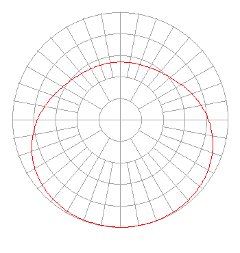 | ||||||||||||||||||
| Azimuth | Ratio | Azimuth | Ratio | Azimuth | Ratio | Azimuth | Ratio | ||||||||||||
| 0 | 0.534 | 10 | 0.537 | 20 | 0.544 | 30 | 0.557 | ||||||||||||
| 40 | 0.578 | 50 | 0.610 | 60 | 0.654 | 70 | 0.706 | ||||||||||||
| 80 | 0.763 | 90 | 0.818 | 100 | 0.868 | 110 | 0.910 | ||||||||||||
| 120 | 0.942 | 130 | 0.964 | 140 | 0.980 | 150 | 0.990 | ||||||||||||
| 160 | 0.996 | 170 | 0.999 | 180 | 0.999 | 190 | 0.994 | ||||||||||||
| 200 | 0.990 | 210 | 0.980 | 220 | 0.964 | 230 | 0.942 | ||||||||||||
| 240 | 0.910 | 250 | 0.868 | 260 | 0.818 | 270 | 0.763 | ||||||||||||
| 280 | 0.706 | 290 | 0.654 | 300 | 0.610 | 310 | 0.578 | ||||||||||||
| 320 | 0.557 | 330 | 0.544 | 340 | 0.537 | 350 | 0.534 | ||||||||||||
Structure Registration Number 1040453 Structure Type: TOWER Registered To: Goosetown Network Services, LLC. Structure Address: Route 52 Ellenville, NY County Name: Ulster County ASR Issued: 02/10/2007 Date Built: 01/01/1973 Site Elevation: 693.1 m (2274 ft.) Structure Height: 22.9 m (75 ft.) Height Overall: 32.9 m (108 ft.) Overall Height AMSL: 726 m (2382 ft.) FAA Determination: 08/06/1973 FAA Study #: 73-EA-774-OE Paint & Light FAA Chapters: NONE 41-41-01.0 N 74-21-23.0 W (NAD 83) 41-41-00.7 N 74-21-24.4 W (Converted to NAD 27) |
Po Box 920 15 Neversink Drive Port Jervis, NY 12771 Phone: 845-856-5185 | Date: 08/31/2015 Application Certifier DIGITAL RADIO BROADCASTING, INC. Po Box 920 15 Neversink Drive Port Jervis, NY 12771 Applicant CHARLES WILLIAMSON Digital Radio Engineering, Inc. Po Box 920 15 Neversink Drive Port Jervis, NY 12771 PRESIDENT DAVID G. O'NEIL, ESQ. Rini O'neil, Pc 1200 New Hampshire Avenue, Nw Suite 800 Washington, DC 20036 | |||||||||||||||||