
FCCInfo.com
A Service of Cavell, Mertz & Associates, Inc.
(855) FCC-INFO
|
|
|
|
|
||||||||||||||||
|
|
W232CM Channel: 232D 94.3 MHz Wauseon, Ohio Service: FX - A translator or application for a translator. Facility ID: 142063 Fac. Service: FX Programming Delivery Method: Unspecified Status: License Application Accepted: 09/07/2018 Application Granted: 09/12/2018 File Number: BLFT-20180907AAI License Expires: 00/00/0000 Prefix Type: This is a license for a translator Application Type: License To Cover FCC Website Links: LMS Facility Details This Application CDBS Application Other W232CM Applications Other W232CM Applications in CDBS Including Superseded Applications Mailing Address Correspondence for W232CM Correspondence related to application BLFT-20180907AAI Service Contour - Open Street Map or USGS Map (60 dBu) Service Contour - KML / Google Earth (60 dBu) Class: D, A Noncommercial educational operating with no more than 10W Site Location: 41-33-29.2 N 84-11-07.8 W (NAD 83) Site Location: 41-33-29.0 N 84-11-08.0 W (Converted to NAD 27) Effective Radiated Power: 0.13 kW Transmitter Output Power: 0.382 kW Antenna Center HAAT: 0 m Antenna Center AMSL: 303 m (994 ft.) Antenna Center HAG: 67 m (220 ft.) Site Elevation: 236 m. (774 ft.) Height Overall*: 117 m (384 ft.) (* As Filed In This Application, may differ from ASR Data, Below.) Directional Antenna Antenna Make/Model: None Antenna ID: 132136 Polarization:
| ||||||||||||||||||
| Antenna Data for Antenna Id: 132136 W232CM FX File: BLFT-20180907AAI None - Service: FX | 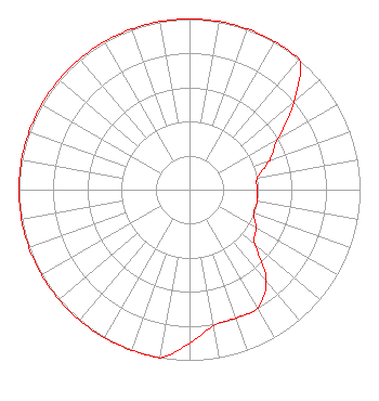 | ||||||||||||||||||
| Azimuth | Ratio | Azimuth | Ratio | Azimuth | Ratio | Azimuth | Ratio | ||||||||||||
| 0 | 1.000 | 10 | 1.000 | 20 | 1.000 | 30 | 1.000 | ||||||||||||
| 40 | 1.000 | 50 | 0.800 | 60 | 0.600 | 70 | 0.500 | ||||||||||||
| 80 | 0.404 | 90 | 0.398 | 100 | 0.403 | 110 | 0.399 | ||||||||||||
| 120 | 0.450 | 130 | 0.500 | 140 | 0.700 | 150 | 0.800 | ||||||||||||
| 160 | 0.800 | 170 | 0.810 | 180 | 0.900 | 190 | 1.000 | ||||||||||||
| 200 | 1.000 | 210 | 1.000 | 220 | 1.000 | 230 | 1.000 | ||||||||||||
| 240 | 1.000 | 250 | 1.000 | 260 | 1.000 | 270 | 1.000 | ||||||||||||
| 280 | 1.000 | 290 | 1.000 | 300 | 1.000 | 310 | 1.000 | ||||||||||||
| 320 | 1.000 | 330 | 1.000 | 340 | 1.000 | 350 | 1.000 | ||||||||||||
Structure Registration Number 1038620 Structure Type: GTOWER Registered To: NOBCO INC. Structure Address: 753 Township Road W21 Wauseon, OH County Name: Fulton County ASR Issued: 11/21/2016 Date Built: 12/15/1988 Site Elevation: 236.3 m (775 ft.) Structure Height: 115.8 m (380 ft.) Height Overall: 116.7 m (383 ft.) Overall Height AMSL: 353 m (1158 ft.) FAA Determination: 07/14/1988 FAA Study #: 88-AGL-627-OE FAA Circular #: 70/7460-1G Paint & Light FAA Chapters: 3, 4, 5, 9 41-33-29.1 N 84-11-07.8 W (NAD 83) 41-33-28.9 N 84-11-08.0 W (Converted to NAD 27) |
303 1/2 North Defiance St. Archbold, OH 43502-1162 Phone: 419-445-9050 | Date: 09/07/2018 Application Certifier NOBCO, INC. 303 1/2 North Defiance St. Archbold, OH 43502 Applicant JUSTIN ASHER Asher Broadcast Consulting, Llc 579 Babcock Road Bronson, MI 49028-9347 TECHNICAL CONSULTANT MARISSA G. REPP, ESQ. Repp Law Firm 1629 K Street, Nw Suite 300 Washington, DC 20006-1631 | |||||||||||||||||