
FCCInfo.com
A Service of Cavell, Mertz & Associates, Inc.
(855) FCC-INFO
|
|
WJGK from 08/05/1984 |
|  |
|
|||||||||||||||
|
|
WJGK Channel: 276A 103.1 MHz Newburgh, New York Service: FM - A full-service FM station or application. Facility ID: 63943 Fac. Service: FM Analog & Digital Status: License 73.215 Station Application Accepted: 12/19/1997 Application Granted: 03/30/1998 File Number: BLH-19971219KE License Expires: 00/00/0000 Prefix Type: This is a license for a commercial FM station Application Type: License To Cover FCC Website Links: LMS Facility Details This Application CDBS Application Other WJGK Applications Other WJGK Applications in CDBS Including Superseded Applications Mailing Address Correspondence for WJGK Correspondence related to application BLH-19971219KE Service Contour - Open Street Map or USGS Map (60 dBu) Service Contour - KML / Google Earth (60 dBu) Public Inspection Files History Cards for WJGK Facility Type: FM STATION Class: A, A Zone I; I-A; or II station; with 0.1kW-6kW ERP and a class contour distance <=28km Site Location: 41-28-25.3 N 74-08-20.5 W (NAD 83) Site Location: 41-28-25.0 N 74-08-22.0 W (Converted to NAD 27) Effective Radiated Power: 6 kW Antenna Center HAAT: 85 m (279 ft.) Antenna Center AMSL: 236 m (774 ft.) Antenna Center HAG: 63 m (207 ft.) Calculated Site Elevation: 173 m. (568 ft.) Height Overall*: 68 m (223 ft.) (* As Filed In This Application, may differ from ASR Data, Below.) Directional Antenna Antenna Make/Model: Oddball; usually designed by Applicant ODD970512II Antenna ID: 15228 Polarization:
| ||||||||||||||||||
| Antenna Data for Antenna Id: 15228 WJGK FM File: BLH-19971219KE Oddball; usually designed by Applicant - ODD970512II Service: FM | 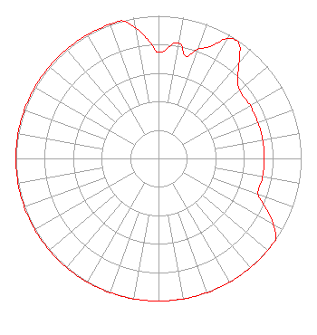 | ||||||||||||||||||
| Azimuth | Ratio | Azimuth | Ratio | Azimuth | Ratio | Azimuth | Ratio | ||||||||||||
| 0 | 0.743 | 10 | 0.821 | 15 | 0.741 | 20 | 0.815 | ||||||||||||
| 25 | 0.867 | 30 | 0.972 | 35 | 0.983 | 40 | 0.880 | ||||||||||||
| 45 | 0.785 | 50 | 0.741 | 60 | 0.741 | 70 | 0.741 | ||||||||||||
| 80 | 0.741 | 90 | 0.741 | 100 | 0.741 | 110 | 0.741 | ||||||||||||
| 115 | 0.831 | 120 | 0.931 | 125 | 1.000 | 130 | 1.000 | ||||||||||||
| 140 | 1.000 | 150 | 1.000 | 160 | 1.000 | 170 | 1.000 | ||||||||||||
| 180 | 1.000 | 190 | 1.000 | 200 | 1.000 | 210 | 1.000 | ||||||||||||
| 220 | 1.000 | 230 | 1.000 | 240 | 1.000 | 250 | 1.000 | ||||||||||||
| 260 | 1.000 | 270 | 1.000 | 280 | 1.000 | 290 | 1.000 | ||||||||||||
| 300 | 1.000 | 310 | 1.000 | 320 | 1.000 | 330 | 1.000 | ||||||||||||
| 340 | 1.000 | 345 | 1.000 | 350 | 0.934 | 355 | 0.833 | ||||||||||||
Structure Registration Number 1007160 Structure Type: TOWER Registered To: SUNRISE BROADCASTING CORPORATION Structure Address: Tolman Rd & Rt 207 New Windsor, NY County Name: Orange County ASR Issued: 12/06/2011 Date Built: 01/01/1977 Site Elevation: 173.1 m (568 ft.) Structure Height: 67.3 m (221 ft.) Height Overall: 68.3 m (224 ft.) Overall Height AMSL: 241.4 m (792 ft.) FAA Determination: 08/07/1997 FAA Study #: 97-AEA-1248-OE FAA Circular #: 70/7460-1J Paint & Light FAA Chapters: 3, 4, 5, 13 41-28-25.3 N 74-08-20.5 W (NAD 83) 41-28-25.0 N 74-08-22.0 W (Converted to NAD 27) |
661 Little Britain Road New Windsor, NY 12553 Phone: 845-561-2131 | Date: 12/19/1997 Application Certifier SUNRISE BROADCASTING OF NEW YORK, INC. Sunrise Broadcasting Of New York, Inc. P.o. Box 2307 Newburgh, NY 12550 Applicant | |||||||||||||||||
| |||||||||||||||||||