
FCCInfo.com
A Service of Cavell, Mertz & Associates, Inc.
(855) FCC-INFO
|
|
W287CY from 05/25/2004 |
|
|
||||||||||||||||
|
|
W287CY Channel: 287D 105.3 MHz Newburgh, New York Service: FX - A translator or application for a translator. Facility ID: 151906 Fac. Service: FX Programming Delivery Method: Unspecified Status: License Application Accepted: 06/09/2017 Application Granted: 06/15/2017 File Number: BLFT-20170609AAI License Expires: 00/00/0000 Prefix Type: This is a license for a translator Application Type: License To Cover FCC Website Links: LMS Facility Details This Application CDBS Application Other W287CY Applications Other W287CY Applications in CDBS Including Superseded Applications Mailing Address Correspondence for W287CY Correspondence related to application BLFT-20170609AAI Service Contour - Open Street Map or USGS Map (60 dBu) Service Contour - KML / Google Earth (60 dBu) Class: D, A Noncommercial educational operating with no more than 10W Site Location: 41-28-25.3 N 74-08-20.5 W (NAD 83) Site Location: 41-28-25.0 N 74-08-22.0 W (Converted to NAD 27) Effective Radiated Power: 0.25 kW Transmitter Output Power: 0.2 kW Antenna Center HAAT: 0 m Antenna Center AMSL: 225 m (738 ft.) Antenna Center HAG: 52 m (171 ft.) Site Elevation: 173 m. (568 ft.) Height Overall*: 68 m (223 ft.) (* As Filed In This Application, may differ from ASR Data, Below.) Directional Antenna Antenna Make/Model: None Antenna ID: 127296 Polarization:
| ||||||||||||||||||
| Antenna Data for Antenna Id: 127296 W287CY FX File: BLFT-20170609AAI None - Service: FX | 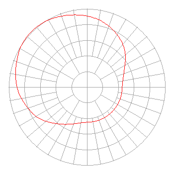 | ||||||||||||||||||
| Azimuth | Ratio | Azimuth | Ratio | Azimuth | Ratio | Azimuth | Ratio | ||||||||||||
| 0 | 0.907 | 10 | 0.872 | 20 | 0.825 | 30 | 0.770 | ||||||||||||
| 40 | 0.710 | 50 | 0.640 | 60 | 0.560 | 70 | 0.500 | ||||||||||||
| 80 | 0.465 | 90 | 0.450 | 100 | 0.450 | 110 | 0.450 | ||||||||||||
| 120 | 0.450 | 130 | 0.450 | 140 | 0.450 | 150 | 0.450 | ||||||||||||
| 160 | 0.450 | 170 | 0.450 | 180 | 0.450 | 190 | 0.465 | ||||||||||||
| 200 | 0.500 | 210 | 0.550 | 220 | 0.610 | 230 | 0.680 | ||||||||||||
| 240 | 0.750 | 250 | 0.800 | 260 | 0.850 | 270 | 0.895 | ||||||||||||
| 280 | 0.925 | 290 | 0.955 | 300 | 0.985 | 310 | 1.000 | ||||||||||||
| 320 | 1.000 | 330 | 0.987 | 340 | 0.962 | 350 | 0.935 | ||||||||||||
Structure Registration Number 1007160 Structure Type: TOWER Registered To: SUNRISE BROADCASTING CORPORATION Structure Address: Tolman Rd & Rt 207 New Windsor, NY County Name: Orange County ASR Issued: 12/06/2011 Date Built: 01/01/1977 Site Elevation: 173.1 m (568 ft.) Structure Height: 67.3 m (221 ft.) Height Overall: 68.3 m (224 ft.) Overall Height AMSL: 241.4 m (792 ft.) FAA Determination: 08/07/1997 FAA Study #: 97-AEA-1248-OE FAA Circular #: 70/7460-1J Paint & Light FAA Chapters: 3, 4, 5, 13 41-28-25.3 N 74-08-20.5 W (NAD 83) 41-28-25.0 N 74-08-22.0 W (Converted to NAD 27) |
661 Little Britain Road New Windsor, NY 12553 Phone: 845-561-2131 | Date: 06/09/2017 Application Certifier SUNRISE BROADCASTING CORPORATION 661 Little Britain Road New Windsor, NY 12553 Applicant CLARENCE M BEVERAGE Communications Technologies, Inc. P.o. Box 1130 Marlton, NJ 08053 BROADCAST ENGINEERING CONSULTANT JEROLD L JACOBS, ESQ. Law Offices Of Jerold L. Jacobs 1629 K Street, N.w. Suite 300 Washington, DC 20006 | |||||||||||||||||