
FCCInfo.com
A Service of Cavell, Mertz & Associates, Inc.
(855) FCC-INFO
|
|
W231CV from 06/25/2004 |
|
|
||||||||||||||||
|
|
W231CV Channel: 231D 94.1 MHz Holly, Michigan Service: FX - A translator or application for a translator. Facility ID: 148503 Fac. Service: FX Programming Delivery Method: Unspecified Status: License Application Accepted: 02/05/2019 Application Granted: 02/07/2019 File Number: BLFT-20190205AAL License Expires: 00/00/0000 Prefix Type: This is a license for a translator Application Type: License To Cover FCC Website Links: LMS Facility Details This Application CDBS Application Other W231CV Applications Other W231CV Applications in CDBS Including Superseded Applications Mailing Address Correspondence for W231CV Correspondence related to application BLFT-20190205AAL Service Contour - Open Street Map or USGS Map (60 dBu) Service Contour - KML / Google Earth (60 dBu) Class: D, A Noncommercial educational operating with no more than 10W Site Location: 42-41-26.0 N 83-17-53.0 W (NAD 83) Site Location: 42-41-25.9 N 83-17-53.2 W (Converted to NAD 27) Effective Radiated Power: 0.21 kW Transmitter Output Power: 0.209 kW Antenna Center HAAT: 0 m Antenna Center AMSL: 364 m (1194 ft.) Antenna Center HAG: 70 m (230 ft.) Site Elevation: 294 m. (965 ft.) Height Overall*: 87 m (285 ft.) (* As Filed In This Application, may differ from ASR Data, Below.) Directional Antenna Antenna Make/Model: None Antenna ID: 127397 Polarization:
| ||||||||||||||||||
| Antenna Data for Antenna Id: 127397 W231CV FX File: BLFT-20190205AAL None - Service: FX | 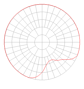 | ||||||||||||||||||
| Azimuth | Ratio | Azimuth | Ratio | Azimuth | Ratio | Azimuth | Ratio | ||||||||||||
| 0 | 1.000 | 10 | 1.000 | 20 | 1.000 | 30 | 1.000 | ||||||||||||
| 40 | 1.000 | 50 | 1.000 | 60 | 1.000 | 70 | 1.000 | ||||||||||||
| 80 | 1.000 | 90 | 1.000 | 100 | 1.000 | 110 | 1.000 | ||||||||||||
| 120 | 0.898 | 130 | 0.719 | 140 | 0.626 | 150 | 0.540 | ||||||||||||
| 160 | 0.539 | 170 | 0.625 | 180 | 0.798 | 190 | 0.937 | ||||||||||||
| 200 | 1.000 | 210 | 1.000 | 220 | 1.000 | 230 | 1.000 | ||||||||||||
| 240 | 1.000 | 250 | 1.000 | 260 | 1.000 | 270 | 1.000 | ||||||||||||
| 280 | 1.000 | 290 | 1.000 | 300 | 1.000 | 310 | 1.000 | ||||||||||||
| 320 | 1.000 | 330 | 1.000 | 340 | 1.000 | 350 | 1.000 | ||||||||||||
Structure Registration Number 1016722 Structure Type: TOWER Registered To: Cellco Partnership Structure Address: 317 Collier Rd Auburn Hills, MI County Name: Oakland County ASR Issued: 02/04/2019 Date Built: 09/02/2004 Site Elevation: 293.8 m (964 ft.) Structure Height: 82.3 m (270 ft.) Height Overall: 86.9 m (285 ft.) Overall Height AMSL: 380.7 m (1249 ft.) FAA Determination: 09/01/2004 FAA Study #: 2004-AGL-5275-OE FAA Circular #: 70/7460-1K Paint & Light FAA Chapters: 4, 8, 12 42-41-26.0 N 83-17-53.0 W (NAD 83) 42-41-25.9 N 83-17-53.2 W (Converted to NAD 27) |
680 Barclay Boulevard Lincolnshire, IL 60069 Phone: 877-291-0123 Not-for-Profit | Date: 02/05/2019 Application Certifier FAMILY LIFE BROADCASTING SYSTEM 7355 North Oracle Road Tucson, AZ 85704 Applicant JOSEPH C. CHAUTIN, III Hardy, Carey, Chautin & Balkin, Llp 1080 West Causeway Approach Mandeville, LA 70471 MICHAEL K. BRINKS 7735 N. Oracle Road Tucson, AZ 85704 DIRECTOR OF SIGNAL DEVELOPMENT AND FCC COMPLIANCE | |||||||||||||||||