
FCCInfo.com
A Service of Cavell, Mertz & Associates, Inc.
(855) FCC-INFO
|
|
|
|
|
||||||||||||||||
|
|
W240CY Channel: 240D 95.9 MHz Mt Bethel, New Jersey Service: FX - A translator or application for a translator. Facility ID: 142668 Fac. Service: FX Programming Delivery Method: Unspecified Status: License Application Accepted: 08/21/2017 Application Granted: 08/28/2017 File Number: BLFT-20170821ABB License Expires: 00/00/0000 Prefix Type: This is a license for a translator Application Type: License To Cover FCC Website Links: LMS Facility Details This Application CDBS Application Other W240CY Applications Other W240CY Applications in CDBS Including Superseded Applications Mailing Address Correspondence for W240CY Correspondence related to application BLFT-20170821ABB Service Contour - Open Street Map or USGS Map (60 dBu) Service Contour - KML / Google Earth (60 dBu) Class: D, A Noncommercial educational operating with no more than 10W Site Location: 40-37-17.4 N 74-30-13.6 W (NAD 83) Site Location: 40-37-17.0 N 74-30-15.0 W (Converted to NAD 27) Effective Radiated Power: 0.005 kW Transmitter Output Power: 0.023 kW Antenna Center HAAT: 0 m Antenna Center AMSL: 230 m (755 ft.) Antenna Center HAG: 63 m (207 ft.) Site Elevation: 167 m. (548 ft.) Height Overall*: 122 m (400 ft.) (* As Filed In This Application, may differ from ASR Data, Below.) Directional Antenna Antenna Make/Model: None Antenna ID: 124401 Polarization:
| ||||||||||||||||||
| Antenna Data for Antenna Id: 124401 W240CY FX File: BLFT-20170821ABB None - Service: FX Pattern and Field Values Include a 330° Clockwise Rotation | 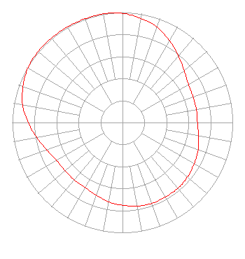 | ||||||||||||||||||
| Azimuth | Ratio | Azimuth | Ratio | Azimuth | Ratio | Azimuth | Ratio | ||||||||||||
| 0 | 0.990 | 10 | 0.960 | 20 | 0.920 | 30 | 0.855 | ||||||||||||
| 40 | 0.790 | 50 | 0.730 | 60 | 0.690 | 70 | 0.680 | ||||||||||||
| 80 | 0.680 | 90 | 0.680 | 100 | 0.700 | 110 | 0.730 | ||||||||||||
| 120 | 0.750 | 130 | 0.770 | 140 | 0.780 | 150 | 0.780 | ||||||||||||
| 160 | 0.780 | 170 | 0.770 | 180 | 0.750 | 190 | 0.730 | ||||||||||||
| 200 | 0.700 | 210 | 0.680 | 220 | 0.680 | 230 | 0.680 | ||||||||||||
| 240 | 0.690 | 250 | 0.730 | 260 | 0.790 | 270 | 0.855 | ||||||||||||
| 280 | 0.920 | 290 | 0.960 | 300 | 0.990 | 310 | 1.000 | ||||||||||||
| 320 | 1.000 | 330 | 1.000 | 340 | 1.000 | 350 | 1.000 | ||||||||||||
Structure Registration Number 1045121 Structure Type: GTOWER Registered To: NEW JERSEY PUBLIC BROADCASTING AUTHORITY Structure Address: 7 Geiger Ln Warren Township, NJ County Name: Somerset County ASR Issued: 03/31/2021 Date Built: 06/15/2021 Site Elevation: 167.1 m (548 ft.) Structure Height: 107.5 m (353 ft.) Height Overall: 122.3 m (401 ft.) Overall Height AMSL: 289.4 m (949 ft.) FAA Determination: 08/31/2020 FAA Study #: 2020-AEA-4180-OE FAA Circular #: 70/7460-1L Paint & Light FAA Chapters: 3, 4, 5, 12 PRIOR STUDY 1992-AEA-1353-OE 40-37-17.0 N 74-30-14.0 W (NAD 83) 40-37-16.6 N 74-30-15.4 W (Converted to NAD 27) |
Po Box 191 Sergeantsville, NJ 08557 Phone: 609-397-1620 | Date: 08/21/2017 Application Certifier PENN-JERSEY EDUCATIONAL RADIO CORPORATION Po Box 191 Sergeantsville, NJ 08557 Applicant CHARLES W. LOUGHERY 532 Ridge Rd Telford, PA 18969 VICE-PRESIDENT/TECHNICAL CONSULTANT CHARLES W. LOUGHERY Charles W. Loughery 532 Ridge Rd Telford, PA 18969 | |||||||||||||||||