
FCCInfo.com
A Service of Cavell, Mertz & Associates, Inc.
(855) FCC-INFO
|
|
KXBZ from 05/03/1990 |
|
|
||||||||||||||||
|
|
KXBZ Channel: 284C2 104.7 MHz Manhattan, Kansas Service: FM - A full-service FM station or application. Facility ID: 37775 Fac. Service: FM Status: License 73.215 Station Application Accepted: 11/14/2011 Application Granted: 11/16/2011 File Number: BMLH-20111114BIR License Expires: 00/00/0000 Prefix Type: This is a modification of a license for a commecial FM station Application Type: Minor Modification FCC Website Links: LMS Facility Details This Application CDBS Application Other KXBZ Applications Other KXBZ Applications in CDBS Including Superseded Applications Mailing Address Correspondence for KXBZ Correspondence related to application BMLH-20111114BIR Service Contour - Open Street Map or USGS Map (60 dBu) Service Contour - KML / Google Earth (60 dBu) Public Inspection Files Facility Type: FM STATION Class: C2, A Zone II station; with 25kW-50kW ERP and a class contour distance 39km-52km Site Location: 39-15-54.8 N 96-27-58.5 W (NAD 83) Site Location: 39-15-54.8 N 96-27-57.5 W (Converted to NAD 27) Effective Radiated Power: 50 kW Transmitter Output Power: 7.8 kW Antenna Center HAAT: 148.8 m (488 ft.) Antenna Center AMSL: 499.9 m (1640 ft.) Antenna Center HAG: 109.9 m (361 ft.) Site Elevation: 390.1 m. (1280 ft.) Height Overall*: 152.1 m (499 ft.) (* As Filed In This Application, may differ from ASR Data, Below.) Directional Antenna Antenna Make/Model: Shivley 6810-8D-CF-DA, EIGHT SECTIONS Antenna ID: 105316 Polarization: | ||||||||||||||||||
| Antenna Data for Antenna Id: 105316 KXBZ FM File: BMLH-20111114BIR Shivley - 6810-8D-CF-DA, EIGHT SECTIONS Service: FM | 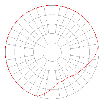 | ||||||||||||||||||
| Azimuth | Ratio | Azimuth | Ratio | Azimuth | Ratio | Azimuth | Ratio | ||||||||||||
| 0 | 1.000 | 10 | 1.000 | 20 | 1.000 | 30 | 1.000 | ||||||||||||
| 40 | 1.000 | 50 | 1.000 | 60 | 1.000 | 70 | 1.000 | ||||||||||||
| 80 | 1.000 | 90 | 0.950 | 100 | 0.880 | 110 | 0.800 | ||||||||||||
| 120 | 0.740 | 130 | 0.710 | 140 | 0.665 | 150 | 0.640 | ||||||||||||
| 160 | 0.660 | 170 | 0.680 | 180 | 0.780 | 190 | 0.900 | ||||||||||||
| 200 | 1.000 | 210 | 1.000 | 220 | 1.000 | 230 | 1.000 | ||||||||||||
| 240 | 1.000 | 250 | 1.000 | 260 | 1.000 | 270 | 1.000 | ||||||||||||
| 280 | 1.000 | 290 | 1.000 | 300 | 1.000 | 310 | 1.000 | ||||||||||||
| 320 | 1.000 | 330 | 1.000 | 340 | 1.000 | 350 | 1.000 | ||||||||||||
Structure Registration Number 1033058 Structure Type: TOWER Registered To: MANHATTAN BROADCASTING CO INC DBA = KMAN-AM / KMKF-FM RADIO Structure Address: 4 Km Ssw Flush, KS County Name: Pottawatomie County ASR Issued: 11/01/2011 Date Built: 01/01/1990 Site Elevation: 390.1 m (1280 ft.) Structure Height: 151.1 m (496 ft.) Height Overall: 152.1 m (499 ft.) Overall Height AMSL: 542.2 m (1779 ft.) FAA Determination: 10/13/2011 FAA Study #: 2011-ACE-2372-OE FAA Circular #: 70/7460-1G Paint & Light FAA Chapters: 3, 4, 5, 9 PRIOR STUDY 2011-ACE-2117-OE 39-15-54.8 N 96-27-58.5 W (NAD 83) 39-15-54.8 N 96-27-57.5 W (Converted to NAD 27) |
2414 Casement Rd Manhattan, KS 66502 Phone: 785-776-1350 Corporation | Date: 11/14/2011 Application Certifier MANHATTAN BROADCASTING CO., INC 2414 Casement Rd. Manhattan, KS 66502 Applicant JEREMY D. RUCK, PE D.l. Markley & Associates, Inc. 2104 West Moss Avenue Peoria, IL 61604 CONSULTING ENGINEER RICHARD R. ZARAGOZA Pillsbury Winthrop Shaw Pittman Llp | |||||||||||||||||
| |||||||||||||||||||