
FCCInfo.com
A Service of Cavell, Mertz & Associates, Inc.
(855) FCC-INFO
|
|
|
|  |
|
||||||||||||||||||
|
|
WJMJ Channel: 205B 88.9 MHz Hartford, Connecticut Service: FM - A full-service FM station or application. Facility ID: 62175 Fac. Service: FM Analog & Digital Status: License Application Accepted: 09/11/2018 Application Granted: 09/20/2018 File Number: BLED-20180911ADG License Expires: 00/00/0000 Prefix Type: This is a license for a noncommercial educational FM station Application Type: License To Cover FCC Website Links: LMS Facility Details This Application CDBS Application Other WJMJ Applications Other WJMJ Applications in CDBS Including Superseded Applications Mailing Address Correspondence for WJMJ Correspondence related to application BLED-20180911ADG Service Contour - Open Street Map or USGS Map (60 dBu) Service Contour - KML / Google Earth (60 dBu) Public Inspection Files History Cards for WJMJ Facility Type: NON-COMMERCIAL EDUC. FM Class: B, A Zone I or I-A station; with 25kW-50kW ERP and a class contour distance 39km-52km Site Location: 41-42-13.4 N 72-49-55.4 W (NAD 83) Site Location: 41-42-13.0 N 72-49-57.0 W (Converted to NAD 27) Effective Radiated Power: 2.3 kW Transmitter Output Power: 2.126 kW Antenna Center HAAT: 436 m (1430 ft.) Antenna Center AMSL: 534 m (1752 ft.) Antenna Center HAG: 318 m (1043 ft.) Site Elevation: 216 m. (709 ft.) Height Overall*: 408 m (1339 ft.) (* As Filed In This Application, may differ from ASR Data, Below.) Directional Antenna Antenna Make/Model: None ERI 1193-1CP-DA, 1 section Antenna ID: 129282 Polarization:
| |||||||||||||||||||||
| Antenna Data for Antenna Id: 129282 WJMJ FM File: BLED-20180911ADG None - ERI 1193-1CP-DA, 1 section Service: FM | 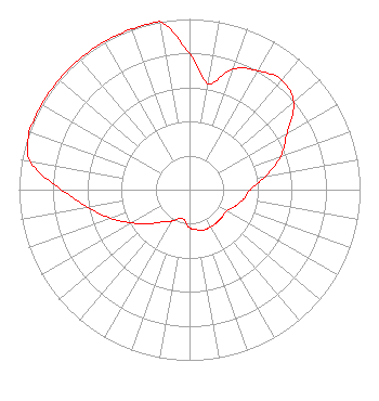 | |||||||||||||||||||||
| Azimuth | Ratio | Azimuth | Ratio | Azimuth | Ratio | Azimuth | Ratio | |||||||||||||||
| 0 | 0.794 | 10 | 0.631 | 20 | 0.753 | 30 | 0.806 | |||||||||||||||
| 40 | 0.839 | 50 | 0.796 | 60 | 0.661 | 70 | 0.569 | |||||||||||||||
| 80 | 0.453 | 90 | 0.359 | 100 | 0.321 | 110 | 0.284 | |||||||||||||||
| 120 | 0.250 | 130 | 0.250 | 140 | 0.250 | 150 | 0.250 | |||||||||||||||
| 160 | 0.250 | 170 | 0.238 | 180 | 0.223 | 190 | 0.180 | |||||||||||||||
| 200 | 0.180 | 210 | 0.213 | 220 | 0.246 | 230 | 0.310 | |||||||||||||||
| 240 | 0.390 | 250 | 0.491 | 260 | 0.603 | 270 | 0.751 | |||||||||||||||
| 280 | 0.946 | 290 | 1.000 | 300 | 1.000 | 310 | 1.000 | |||||||||||||||
| 320 | 1.000 | 330 | 1.000 | 340 | 1.000 | 350 | 1.000 | |||||||||||||||
Structure Registration Number 1041624 Structure Type: Registered To: COMMUNICATIONS SITE MANAGEMENT, LLC Structure Address: 200 Colt Highway Rt. 6 Farmington, CT County Name: Hartford County ASR Issued: 08/24/2015 Date Built: 09/01/1984 Site Elevation: 216.4 m (710 ft.) Structure Height: 393.8 m (1292 ft.) Height Overall: 408.1 m (1339 ft.) Overall Height AMSL: 624.5 m (2049 ft.) FAA Determination: 01/17/1984 FAA Study #: 83-ANE-0395-OE FAA Circular #: 70/7460-1F Paint & Light FAA Chapters: 4, 6, 9 41-42-13.0 N 72-49-55.0 W (NAD 83) 41-42-12.6 N 72-49-56.6 W (Converted to NAD 27) |
Ortv, Inc. - Office Of Radio & Television 15 Peach Orchard Road Prospect,, CT 06712 Phone: 203-758-7367 Private Not-for-Profit Educational Institution | Date: 09/11/2018 Application Certifier ST. THOMAS SEMINARY Archdiocese Of Hartford Office Of Radio 15 Peach Orchard Road Prospect, CT 06078 Applicant BRAD C. DEUTSCH Garvey, Shubert, Barer THOMAS R. RAY, III 377 Chestnut Avenue New Windsor, NY 12553 CONTRACT TRANSMITTER ENGINEER | ||||||||||||||||||||
| ||||||||||||||||||||||