
FCCInfo.com
A Service of Cavell, Mertz & Associates, Inc.
(855) FCC-INFO
|
|
|
|
|
||||||||||||||||
|
|
W275BW Channel: 275D 102.9 MHz Fayetteville, North Carolina Service: FX - A translator or application for a translator. Facility ID: 156007 Fac. Service: FX Programming Delivery Method: Unspecified Status: License Application Accepted: 08/14/2018 Application Granted: 08/20/2018 File Number: BLFT-20180814ABQ License Expires: 00/00/0000 Prefix Type: This is a license for a translator Application Type: License To Cover FCC Website Links: LMS Facility Details This Application CDBS Application Other W275BW Applications Other W275BW Applications in CDBS Including Superseded Applications Mailing Address Correspondence for W275BW Correspondence related to application BLFT-20180814ABQ Service Contour - Open Street Map or USGS Map (60 dBu) Service Contour - KML / Google Earth (60 dBu) Class: D, A Noncommercial educational operating with no more than 10W Site Location: 35-04-46.6 N 78-55-57.1 W (NAD 83) Site Location: 35-04-46.0 N 78-55-58.0 W (Converted to NAD 27) Effective Radiated Power: 0 kW Horiz. ; 0.099 kW Vert. Transmitter Output Power: 0.067 kW Antenna Center HAAT: 0 m Antenna Center AMSL: 0 m Horiz.; 248 m Vert. Antenna Center HAG: 0 m Horiz.; 178 m Vert. Site Elevation: 70 m. (230 ft.) Height Overall*: 250 m (820 ft.) (* As Filed In This Application, may differ from ASR Data, Below.) Directional Antenna Antenna Make/Model: None Antenna ID: 132307 Polarization:
| ||||||||||||||||||
| Antenna Data for Antenna Id: 132307 W275BW FX File: BLFT-20180814ABQ None - Service: FX | 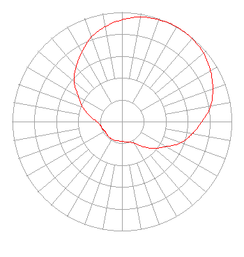 | ||||||||||||||||||
| Azimuth | Ratio | Azimuth | Ratio | Azimuth | Ratio | Azimuth | Ratio | ||||||||||||
| 0 | 0.930 | 10 | 0.970 | 20 | 0.990 | 30 | 1.000 | ||||||||||||
| 40 | 0.990 | 50 | 0.970 | 60 | 0.930 | 70 | 0.880 | ||||||||||||
| 80 | 0.820 | 90 | 0.730 | 100 | 0.650 | 110 | 0.570 | ||||||||||||
| 120 | 0.460 | 130 | 0.380 | 140 | 0.300 | 150 | 0.230 | ||||||||||||
| 160 | 0.200 | 170 | 0.190 | 180 | 0.180 | 190 | 0.180 | ||||||||||||
| 200 | 0.185 | 210 | 0.185 | 220 | 0.185 | 230 | 0.180 | ||||||||||||
| 240 | 0.180 | 250 | 0.190 | 260 | 0.200 | 270 | 0.230 | ||||||||||||
| 280 | 0.300 | 290 | 0.380 | 300 | 0.460 | 310 | 0.570 | ||||||||||||
| 320 | 0.650 | 330 | 0.730 | 340 | 0.820 | 350 | 0.880 | ||||||||||||
Structure Registration Number 1008464 Structure Type: 3TA1 Registered To: VB Nimbus, LLC Structure Address: Twr 1 1009 Drayton Rd Fayetteville, NC County Name: Cumberland County ASR Issued: 10/13/2020 Date Built: 01/01/1985 Site Elevation: 70.1 m (230 ft.) Structure Height: 249.6 m (819 ft.) Height Overall: 249.6 m (819 ft.) Overall Height AMSL: 319.7 m (1049 ft.) FAA Determination: 04/16/1986 FAA Study #: 85-ASO-2112-OE Paint & Light FAA Chapters: A1, B, D, H HIGH INTENSITY WHITE LIGHTS 35-04-47.0 N 78-55-57.0 W (NAD 83) 35-04-46.4 N 78-55-57.9 W (Converted to NAD 27) |
5700 West Oaks Blvd Rocklin, CA 95765 Phone: 916-251-1600 | Date: 08/14/2018 Application Certifier EDUCATIONAL MEDIA FOUNDATION 5700 West Oaks Blvd Rocklin, CA 95765 Applicant STEPHEN WILDE 5700 West Oaks Blvd Rocklin, CA 95765 CONSULTING ENGINEER MARY O'CONNOR Educational Media Foundation 1800 M Street, N.w. Suite 800n Washington, DC 20036 | |||||||||||||||||