
FCCInfo.com
A Service of Cavell, Mertz & Associates, Inc.
(855) FCC-INFO
|
|
|
|  |
|
|||||||||||||||
|
|
WRKI Channel: 236B 95.1 MHz Brookfield, Connecticut Service: FM - A full-service FM station or application. Facility ID: 15391 Fac. Service: FM Status: License Application Accepted: 02/21/2012 Application Granted: 03/08/2012 File Number: BMLH-20120221ADH License Expires: 00/00/0000 Prefix Type: This is a modification of a license for a commecial FM station Application Type: Minor Modification FCC Website Links: LMS Facility Details This Application CDBS Application Other WRKI Applications Other WRKI Applications in CDBS Including Superseded Applications Mailing Address Correspondence for WRKI Correspondence related to application BMLH-20120221ADH Service Contour - Open Street Map or USGS Map (54 dBu) Service Contour - KML / Google Earth (54 dBu) Public Inspection Files History Cards for WRKI Facility Type: FM STATION Class: B, A Zone I or I-A station; with 25kW-50kW ERP and a class contour distance 39km-52km Site Location: 41-29-36.3 N 73-25-43.4 W (NAD 83) Site Location: 41-29-36.0 N 73-25-45.0 W (Converted to NAD 27) Effective Radiated Power: 29.5 kW Transmitter Output Power: 19.89 kW Antenna Center HAAT: 194 m (636 ft.) Antenna Center AMSL: 367 m (1204 ft.) Antenna Center HAG: 147 m (482 ft.) Site Elevation: 218 m. (715 ft.) Height Overall*: 152 m (499 ft.) (* As Filed In This Application, may differ from ASR Data, Below.) Directional Antenna Antenna Make/Model: Electronics Research Inc. FML-2E-DA-SP Antenna ID: 14830 Polarization: | ||||||||||||||||||
| Antenna Data for Antenna Id: 14830 WRKI FM File: BMLH-20120221ADH Electronics Research Inc. - FML-2E-DA-SP Service: FM | 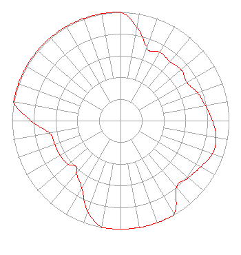 | ||||||||||||||||||
| Azimuth | Ratio | Azimuth | Ratio | Azimuth | Ratio | Azimuth | Ratio | ||||||||||||
| 0 | 1.000 | 10 | 0.875 | 20 | 0.717 | 23 | 0.696 | ||||||||||||
| 30 | 0.727 | 40 | 0.708 | 50 | 0.729 | 60 | 0.705 | ||||||||||||
| 70 | 0.754 | 80 | 0.794 | 90 | 0.847 | 100 | 0.896 | ||||||||||||
| 110 | 0.902 | 120 | 0.853 | 130 | 0.819 | 140 | 0.802 | ||||||||||||
| 150 | 0.990 | 160 | 1.000 | 170 | 1.000 | 180 | 1.000 | ||||||||||||
| 190 | 1.000 | 200 | 0.889 | 210 | 0.715 | 220 | 0.635 | ||||||||||||
| 224 | 0.588 | 230 | 0.628 | 240 | 0.645 | 250 | 0.645 | ||||||||||||
| 260 | 0.665 | 270 | 0.827 | 280 | 1.000 | 290 | 1.000 | ||||||||||||
| 300 | 1.000 | 310 | 1.000 | 320 | 1.000 | 330 | 1.000 | ||||||||||||
| 340 | 1.000 | 350 | 1.000 | ||||||||||||||||
Structure Registration Number 1045933 Structure Type: GTOWER Registered To: VB-S1 Assets, LLC Structure Address: 0.3 Mi. Sse Of Intersection Of Carmen Hill Rd & Se Trail Brookfield, CT County Name: Fairfield County ASR Issued: 01/30/2018 Date Built: 01/01/1996 Site Elevation: 218.5 m (717 ft.) Structure Height: 151.2 m (496 ft.) Height Overall: 152.1 m (499 ft.) Overall Height AMSL: 370.6 m (1216 ft.) FAA Determination: 01/13/2016 FAA Study #: 2016-ANE-12-OE FAA Circular #: 70/7460-1L Paint & Light FAA Chapters: 4, 8, 12 PRIOR STUDY 2009-ANE-1283-OE 41-29-36.7 N 73-25-43.9 W (NAD 83) 41-29-36.4 N 73-25-45.5 W (Converted to NAD 27) |
1 Manhattanville Road Suite 202 Purchase, NY 10577 Phone: 203-861-0900 Limited Liability Company | Date: 02/21/2012 Application Certifier CUMULUS LICENSING LLC 3280 Peachtree Road, Nw Suite 2300 Atlanta, GA 30305 Applicant JEFFERSON G. BROCK Graham Brock, Inc. P.o. Box 24466 St. Simons Island, GA 31522-7466 TECHNICAL CONSULTANT MARK N. LIPP, ESQ. Wiley Rein Llp | |||||||||||||||||
| |||||||||||||||||||