
FCCInfo.com
A Service of Cavell, Mertz & Associates, Inc.
(855) FCC-INFO
|
|
W260CB from 10/26/2000 |
|
|
||||||||||||||||
|
|
W260CB Channel: 260D 99.9 MHz Detroit, Michigan Service: FX - A translator or application for a translator. Facility ID: 93456 Fac. Service: FX Programming Delivery Method: Unspecified Status: License Application Accepted: 03/28/2018 Application Granted: 04/03/2018 File Number: BLFT-20180328AAB License Expires: 00/00/0000 Prefix Type: This is a license for a translator Application Type: License To Cover FCC Website Links: LMS Facility Details This Application CDBS Application Other W260CB Applications Other W260CB Applications in CDBS Including Superseded Applications Mailing Address Correspondence for W260CB Correspondence related to application BLFT-20180328AAB Service Contour - Open Street Map or USGS Map (60 dBu) Service Contour - KML / Google Earth (60 dBu) Class: D, A Noncommercial educational operating with no more than 10W Site Location: 42-27-13.1 N 83-09-49.7 W (NAD 83) Site Location: 42-27-13.0 N 83-09-50.0 W (Converted to NAD 27) Effective Radiated Power: 0.25 kW Transmitter Output Power: 0.405 kW Antenna Center HAAT: 0 m Antenna Center AMSL: 447 m (1467 ft.) Antenna Center HAG: 244 m (801 ft.) Site Elevation: 203 m. (666 ft.) Height Overall*: 305 m (1001 ft.) (* As Filed In This Application, may differ from ASR Data, Below.) Directional Antenna Antenna Make/Model: None Antenna ID: 127040 Polarization:
| ||||||||||||||||||
| Antenna Data for Antenna Id: 127040 W260CB FX File: BLFT-20180328AAB None - Service: FX | 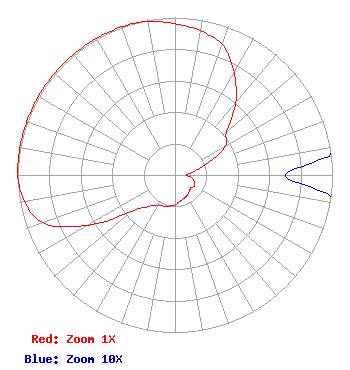 | ||||||||||||||||||
| Azimuth | Ratio | Azimuth | Ratio | Azimuth | Ratio | Azimuth | Ratio | ||||||||||||
| 0 | 0.960 | 10 | 0.930 | 20 | 0.880 | 30 | 0.750 | ||||||||||||
| 40 | 0.600 | 50 | 0.430 | 60 | 0.370 | 70 | 0.220 | ||||||||||||
| 80 | 0.120 | 90 | 0.070 | 100 | 0.110 | 110 | 0.130 | ||||||||||||
| 120 | 0.140 | 130 | 0.130 | 140 | 0.140 | 150 | 0.150 | ||||||||||||
| 160 | 0.160 | 170 | 0.170 | 180 | 0.190 | 190 | 0.200 | ||||||||||||
| 200 | 0.210 | 210 | 0.220 | 220 | 0.260 | 230 | 0.360 | ||||||||||||
| 240 | 0.640 | 250 | 0.890 | 260 | 0.970 | 270 | 1.000 | ||||||||||||
| 280 | 1.000 | 290 | 1.000 | 300 | 1.000 | 310 | 1.000 | ||||||||||||
| 320 | 1.000 | 330 | 1.000 | 340 | 1.000 | 350 | 0.990 | ||||||||||||
Structure Registration Number 1001506 [ASR Heights Differ from W260CB Application] Structure Type: GTOWER Registered To: American Towers LLC Structure Address: One Radio Plaza (203686) Royal Oak, MI County Name: Oakland County ASR Issued: 01/31/2018 Date Built: 01/01/1974 Site Elevation: 201.5 m (661 ft.) Structure Height: 282 m (925 ft.) Height Overall: 302.3 m (992 ft.) Overall Height AMSL: 503.8 m (1653 ft.) FAA Determination: 01/26/2018 FAA Study #: 2017-AGL-21768-OE FAA Circular #: 70/7460-1L Paint & Light FAA Chapters: 4, 9, 12 PRIOR STUDY 1973-AGL-347-OE 42-27-12.9 N 83-09-49.1 W (NAD 83) 42-27-12.8 N 83-09-49.4 W (Converted to NAD 27) |
3033 Riviera Drive Suite 200 Naples, FL 34103 Phone: 239-263-5000 Limited Liability Company | Date: 03/28/2018 Application Certifier RADIO ONE OF DETROIT, LLC 1010 Wayne Avenue 14th Floor Silver Spring, MD 20910 Applicant GREG STRICKLAND Urban One, Inc 1010 Wayne Avenue, 14th Floor Silver Spring, MD 20910 CORPORATE ENGINEER SONYA M. HALL-HARRIS Radio One, Inc. 1010 Wayne Avenue 14th Floor Silver Spring, MD 20910 | |||||||||||||||||