
FCCInfo.com
A Service of Cavell, Mertz & Associates, Inc.
(855) FCC-INFO
|
|
|
|  |
|
|||||||||||||||
|
|
KAOG Channel: 213C2 90.5 MHz Jonesboro, Arkansas Service: FM - A full-service FM station or application. Facility ID: 1673 Fac. Service: FM Status: License Application Accepted: 02/07/2000 Application Granted: 05/02/2000 File Number: BLED-20000127AAM License Expires: 00/00/0000 Prefix Type: This is a license for a noncommercial educational FM station Application Type: License To Cover FCC Website Links: LMS Facility Details This Application CDBS Application Other KAOG Applications Other KAOG Applications in CDBS Including Superseded Applications Mailing Address Correspondence for KAOG Correspondence related to application BLED-20000127AAM Service Contour - Open Street Map or USGS Map (60 dBu) Service Contour - KML / Google Earth (60 dBu) Public Inspection Files Facility Type: NON-COMMERCIAL EDUC. FM Class: C2, A Zone II station; with 25kW-50kW ERP and a class contour distance 39km-52km Site Location: 35-48-36.3 N 90-48-45.4 W (NAD 83) Site Location: 35-48-36.0 N 90-48-45.0 W (Converted to NAD 27) Effective Radiated Power: 40 kW Transmitter Output Power: 6.995 kW Antenna Center HAAT: 121 m (397 ft.) Antenna Center AMSL: 200 m (656 ft.) Antenna Center HAG: 115 m (377 ft.) Calculated Site Elevation: 85 m. (279 ft.) Height Overall*: 125 m (410 ft.) (* As Filed In This Application, may differ from ASR Data, Below.) Directional Antenna Antenna Make/Model: Shivley 6810-7RDA Antenna ID: 15837 Polarization:
| ||||||||||||||||||
| Antenna Data for Antenna Id: 15837 KAOG FM File: BLED-20000127AAM Shivley - 6810-7RDA Service: FM | 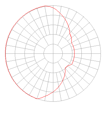 | ||||||||||||||||||
| Azimuth | Ratio | Azimuth | Ratio | Azimuth | Ratio | Azimuth | Ratio | ||||||||||||
| 0 | 0.950 | 10 | 0.850 | 20 | 0.750 | 30 | 0.650 | ||||||||||||
| 40 | 0.550 | 45 | 0.525 | 50 | 0.500 | 60 | 0.450 | ||||||||||||
| 70 | 0.450 | 80 | 0.450 | 90 | 0.450 | 100 | 0.450 | ||||||||||||
| 110 | 0.450 | 120 | 0.450 | 130 | 0.400 | 135 | 0.400 | ||||||||||||
| 140 | 0.400 | 150 | 0.500 | 160 | 0.600 | 170 | 0.700 | ||||||||||||
| 180 | 0.800 | 190 | 0.900 | 200 | 1.000 | 210 | 1.000 | ||||||||||||
| 220 | 1.000 | 225 | 1.000 | 230 | 1.000 | 240 | 1.000 | ||||||||||||
| 250 | 1.000 | 260 | 1.000 | 270 | 1.000 | 280 | 1.000 | ||||||||||||
| 290 | 1.000 | 300 | 1.000 | 310 | 1.000 | 315 | 1.000 | ||||||||||||
| 320 | 1.000 | 330 | 1.000 | 340 | 1.000 | 350 | 1.000 | ||||||||||||
Structure Registration Number 1053082 Structure Type: TOWER Registered To: AMERICAN FAMILY ASSOCIATION Structure Address: County Rd 102 Jonesboro, AR County Name: Craighead County ASR Issued: 10/21/2009 Date Built: 03/02/1999 Site Elevation: 85 m (279 ft.) Structure Height: 125 m (410 ft.) Height Overall: 125 m (410 ft.) Overall Height AMSL: 210 m (689 ft.) FAA Determination: 02/03/1998 FAA Study #: 97-ASW-3963-OE FAA Circular #: 70/7460-1J Paint & Light FAA Chapters: 4, 6, 13 35-48-36.0 N 90-48-45.0 W (NAD 83) 35-48-35.7 N 90-48-44.6 W (Converted to NAD 27) |
Po Box 2440 Tupelo, MS 38801-2440 Phone: 662-844-8888 Not-for-Profit | Date: 01/27/2000 Application Certifier AMERICAN FAMILY ASSOCIATION P.o. Drawer 2440 Tupelo, MS 38803 Applicant MARSHA B. SHRADER | |||||||||||||||||