
FCCInfo.com
A Service of Cavell, Mertz & Associates, Inc.
(855) FCC-INFO
|
|
W232CA from 06/14/2007 W232CA from 06/16/2004 |
|
|
||||||||||||||||
|
|
W232CA Channel: 232D 94.3 MHz Detroit, Michigan Service: FX - A translator or application for a translator. Facility ID: 152374 Fac. Service: FX Programming Delivery Method: Unspecified Status: License Application Accepted: 12/14/2018 Application Granted: 12/19/2018 File Number: BLFT-20181214AAJ License Expires: 00/00/0000 Prefix Type: This is a license for a translator Application Type: License To Cover FCC Website Links: LMS Facility Details This Application CDBS Application Other W232CA Applications Other W232CA Applications in CDBS Including Superseded Applications Mailing Address Correspondence for W232CA Correspondence related to application BLFT-20181214AAJ Service Contour - Open Street Map or USGS Map (60 dBu) Service Contour - KML / Google Earth (60 dBu) Class: D, A Noncommercial educational operating with no more than 10W Site Location: 42-26-53.1 N 83-10-22.7 W (NAD 83) Site Location: 42-26-53.0 N 83-10-23.0 W (Converted to NAD 27) Effective Radiated Power: 0.099 kW Transmitter Output Power: 0.186 kW Antenna Center HAAT: 0 m Antenna Center AMSL: 476 m (1562 ft.) Antenna Center HAG: 274 m (899 ft.) Site Elevation: 202 m. (663 ft.) Height Overall*: 331 m (1086 ft.) (* As Filed In This Application, may differ from ASR Data, Below.) Directional Antenna Antenna Make/Model: None Antenna ID: 127398 Polarization:
| ||||||||||||||||||
| Antenna Data for Antenna Id: 127398 W232CA FX File: BLFT-20181214AAJ None - Service: FX | 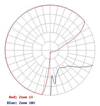 | ||||||||||||||||||
| Azimuth | Ratio | Azimuth | Ratio | Azimuth | Ratio | Azimuth | Ratio | ||||||||||||
| 0 | 1.000 | 10 | 1.000 | 20 | 1.000 | 30 | 1.000 | ||||||||||||
| 40 | 1.000 | 50 | 1.000 | 60 | 0.750 | 70 | 0.350 | ||||||||||||
| 80 | 0.230 | 90 | 0.165 | 100 | 0.125 | 110 | 0.100 | ||||||||||||
| 120 | 0.075 | 130 | 0.055 | 140 | 0.050 | 150 | 0.045 | ||||||||||||
| 160 | 0.050 | 170 | 0.070 | 180 | 0.150 | 190 | 1.000 | ||||||||||||
| 200 | 1.000 | 210 | 1.000 | 220 | 1.000 | 230 | 1.000 | ||||||||||||
| 240 | 1.000 | 250 | 1.000 | 260 | 1.000 | 270 | 1.000 | ||||||||||||
| 280 | 1.000 | 290 | 1.000 | 300 | 1.000 | 310 | 1.000 | ||||||||||||
| 320 | 1.000 | 330 | 1.000 | 340 | 1.000 | 350 | 1.000 | ||||||||||||
Structure Registration Number 1003429 Structure Type: GTOWER Registered To: American Towers LLC Structure Address: 20931 Meyers Rd (282678 / Detroit - Oak Park T1 Mi) Oak Park, MI County Name: Oakland County ASR Issued: 10/14/2016 Date Built: 06/11/1999 Site Elevation: 201.8 m (662 ft.) Structure Height: 308.5 m (1012 ft.) Height Overall: 331.3 m (1087 ft.) Overall Height AMSL: 533.1 m (1749 ft.) FAA Determination: 07/07/2016 FAA Study #: 2016-AGL-8945-OE FAA Circular #: 70/7460-1L Paint & Light FAA Chapters: 4, 9, 12 PRIOR STUDY 2014-AGL-12680-OE 42-26-52.5 N 83-10-23.1 W (NAD 83) 42-26-52.4 N 83-10-23.4 W (Converted to NAD 27) |
680 Barclay Boulevard Lincolnshire, IL 60069 Phone: 877-291-0123 Not-for-Profit | Date: 12/14/2018 Application Certifier FAMILY LIFE BROADCASTING SYSTEM 7355 North Oracle Road Tucson, AZ 85704 Applicant MICHAEL K. BRINKS 7735 N. Oracle Road Tucson, AZ 85704 DIRECTOR OF SIGNAL DEVELOPMENT AND FCC COMPLIANCE JOSEPH C. CHAUTIN, III Hardy, Carey, Chautin & Balkin, Llp 1080 West Causeway Approach Mandeville, LA 70471 | |||||||||||||||||