
FCCInfo.com
A Service of Cavell, Mertz & Associates, Inc.
(855) FCC-INFO
|
|
|
|
|
||||||||||||||||
|
|
WPKN Channel: 208B 89.5 MHz Bridgeport, Connecticut Service: FM - A full-service FM station or application. Facility ID: 73886 Fac. Service: FM Status: License Application Accepted: 02/01/2006 Application Granted: 03/29/2006 File Number: BMLED-20060201AYV License Expires: 00/00/0000 Prefix Type: This is a modification of license for a noncommercial educational FM station Application Type: Minor Amendment FCC Website Links: LMS Facility Details This Application CDBS Application Other WPKN Applications Other WPKN Applications in CDBS Including Superseded Applications Mailing Address Correspondence for WPKN Correspondence related to application BMLED-20060201AYV Service Contour - Open Street Map or USGS Map (60 dBu) Service Contour - KML / Google Earth (60 dBu) Public Inspection Files History Cards for WPKN Facility Type: NON-COMMERCIAL EDUC. FM Class: B, A Zone I or I-A station; with 25kW-50kW ERP and a class contour distance 39km-52km Site Location: 41-16-44.3 N 73-11-06.4 W (NAD 83) Site Location: 41-16-44.0 N 73-11-08.0 W (Converted to NAD 27) Effective Radiated Power: 10 kW Transmitter Output Power: 7.24 kW Antenna Center HAAT: 169 m (554 ft.) Antenna Center AMSL: 253 m (830 ft.) Antenna Center HAG: 91 m (299 ft.) Calculated Site Elevation: 162 m. (531 ft.) Height Overall*: 150 m (492 ft.) (* As Filed In This Application, may differ from ASR Data, Below.) Directional Antenna Antenna Make/Model: Shivley 6015-2/3R-DA Antenna ID: 14484 Polarization:
| ||||||||||||||||||
| Antenna Data for Antenna Id: 14484 WPKN FM File: BMLED-20060201AYV Shivley - 6015-2/3R-DA Service: FM | 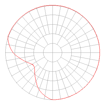 | ||||||||||||||||||
| Azimuth | Ratio | Azimuth | Ratio | Azimuth | Ratio | Azimuth | Ratio | ||||||||||||
| 0 | 1.000 | 10 | 1.000 | 20 | 1.000 | 30 | 1.000 | ||||||||||||
| 40 | 1.000 | 50 | 1.000 | 60 | 1.000 | 70 | 1.000 | ||||||||||||
| 80 | 1.000 | 90 | 1.000 | 100 | 1.000 | 110 | 1.000 | ||||||||||||
| 120 | 1.000 | 130 | 1.000 | 140 | 1.000 | 150 | 1.000 | ||||||||||||
| 160 | 1.000 | 170 | 1.000 | 180 | 1.000 | 190 | 0.930 | ||||||||||||
| 200 | 0.835 | 210 | 0.700 | 220 | 0.585 | 230 | 0.500 | ||||||||||||
| 235 | 0.490 | 236 | 0.490 | 240 | 0.500 | 250 | 0.585 | ||||||||||||
| 260 | 0.700 | 270 | 0.835 | 280 | 0.930 | 290 | 1.000 | ||||||||||||
| 300 | 1.000 | 310 | 1.000 | 320 | 1.000 | 330 | 1.000 | ||||||||||||
| 340 | 1.000 | 350 | 1.000 | ||||||||||||||||
Structure Registration Number 1205267 [ASR Heights Differ from WPKN Application] Structure Type: GTOWER Registered To: Pinnacle Towers LLC Structure Address: Booth Hill Road Trumbull, CT County Name: Fairfield County ASR Issued: 09/01/2022 Date Built: 06/01/1953 Site Elevation: 158.5 m (520 ft.) Structure Height: 140.2 m (460 ft.) Height Overall: 151.2 m (496 ft.) Overall Height AMSL: 309.7 m (1016 ft.) FAA Determination: 11/05/2020 FAA Study #: 2020-ANE-6216-OE FAA Circular #: 70/7460-1L Paint & Light FAA Chapters: 4, 8, 12 PRIOR STUDY 2020-ANE-5789-OE 41-16-44.3 N 73-11-06.4 W (NAD 83) 41-16-44.0 N 73-11-08.0 W (Converted to NAD 27) |
277 Fairfield Avenue Bridgeport, CT 06604 Phone: 203-331-9756 Not-for-Profit | Date: 02/01/2006 Application Certifier WPKN, INC. 244 University Avenue Bridgeport, CT 06604 Applicant LAURA M. MIZRAHI Communications Technologies, Inc. P.o. Box 1130 Marlton, NJ 08053 TECHNICAL CONSULTANT MARK N. LIPP, ESQ. Vinson & Elkins L.l.p. | |||||||||||||||||
| |||||||||||||||||||