
FCCInfo.com
A Service of Cavell, Mertz & Associates, Inc.
(855) FCC-INFO
|
|
|
|
|
||||||||||||||||
|
|
W291BV Channel: 291D 106.1 MHz Solon, Ohio Service: FX - A translator or application for a translator. Facility ID: 141400 Fac. Service: FX Programming Delivery Method: Unspecified Status: License Application Accepted: 12/11/2018 Application Granted: 12/19/2018 File Number: BLFT-20181211AAK License Expires: 00/00/0000 Prefix Type: This is a license for a translator Application Type: License To Cover FCC Website Links: LMS Facility Details This Application CDBS Application Other W291BV Applications Other W291BV Applications in CDBS Including Superseded Applications Mailing Address Correspondence for W291BV Correspondence related to application BLFT-20181211AAK Service Contour - Open Street Map or USGS Map (60 dBu) Service Contour - KML / Google Earth (60 dBu) Class: D, A Noncommercial educational operating with no more than 10W Site Location: 41-22-45.0 N 81-43-11.0 W (NAD 83) Site Location: 41-22-44.8 N 81-43-11.5 W (Converted to NAD 27) Effective Radiated Power: 0.2 kW Transmitter Output Power: 0.217 kW Antenna Center HAAT: 0 m Antenna Center AMSL: 525 m (1722 ft.) Antenna Center HAG: 204 m (669 ft.) Site Elevation: 321 m. (1053 ft.) Height Overall*: 289 m (948 ft.) (* As Filed In This Application, may differ from ASR Data, Below.) Directional Antenna Antenna Make/Model: None Antenna ID: 133640 Polarization:
| ||||||||||||||||||
| Antenna Data for Antenna Id: 133640 W291BV FX File: BLFT-20181211AAK None - Service: FX | 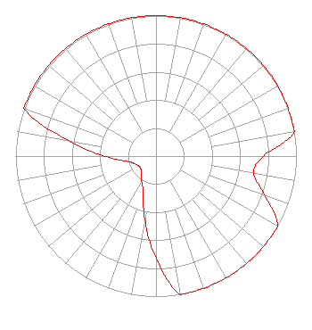 | ||||||||||||||||||
| Azimuth | Ratio | Azimuth | Ratio | Azimuth | Ratio | Azimuth | Ratio | ||||||||||||
| 0 | 1.000 | 10 | 1.000 | 20 | 1.000 | 30 | 1.000 | ||||||||||||
| 40 | 1.000 | 50 | 1.000 | 60 | 1.000 | 70 | 1.000 | ||||||||||||
| 80 | 1.000 | 90 | 0.765 | 100 | 0.707 | 110 | 0.827 | ||||||||||||
| 120 | 1.000 | 130 | 1.000 | 140 | 1.000 | 150 | 1.000 | ||||||||||||
| 160 | 1.000 | 170 | 1.000 | 180 | 0.729 | 190 | 0.456 | ||||||||||||
| 200 | 0.273 | 210 | 0.204 | 220 | 0.161 | 230 | 0.142 | ||||||||||||
| 240 | 0.143 | 250 | 0.161 | 260 | 0.212 | 270 | 0.372 | ||||||||||||
| 280 | 0.631 | 290 | 1.000 | 300 | 1.000 | 310 | 1.000 | ||||||||||||
| 320 | 1.000 | 330 | 1.000 | 340 | 1.000 | 350 | 1.000 | ||||||||||||
Structure Registration Number 1012090 Structure Type: Registered To: Gray Media Group, Inc. Structure Address: 4800 Bruening Dr Parma, OH County Name: Cuyahoga County ASR Issued: 03/07/2024 Date Built: 01/01/1992 Site Elevation: 320.6 m (1052 ft.) Structure Height: 270.7 m (888 ft.) Height Overall: 288.6 m (947 ft.) Overall Height AMSL: 609.2 m (1999 ft.) FAA Determination: 08/20/1991 FAA Study #: 91-AGL-1298-OE FAA Circular #: 70/7460-1H Paint & Light FAA Chapters: 3, 4, 5, 13 41-22-45.0 N 81-43-11.0 W (NAD 83) 41-22-44.8 N 81-43-11.5 W (Converted to NAD 27) |
7136 S. Yale Avenue Suite 501 Tulsa, OK 74136 Phone: 918-664-4581 | Date: 12/11/2018 Application Certifier EDUCATIONAL MEDIA FOUNDATION 5700 West Oaks Blvd. Rocklin, CA 95765 Applicant MARY O'CONNOR Wilkinson Barker Knauer, Llp 1800 M Street, N.w. Suite 800n Washington, DC 20036 TROY G. LANGHAM 7136 South Yale Avenue Suite 501 Tulsa, OK 74136 ENGINEER FOR PRIMARY | |||||||||||||||||