
FCCInfo.com
A Service of Cavell, Mertz & Associates, Inc.
(855) FCC-INFO
|
|
WOKL from 02/17/2012 WOKL from 01/11/2011 WOKL from 12/27/2010 WOKL from 12/12/2010 |
|
|
||||||||||||||||
|
|
WOKL Channel: 206A 89.1 MHz Round Lake Beach, Illinois Service: FM - A full-service FM station or application. Facility ID: 175042 Fac. Service: FM Status: License Application Accepted: 01/03/2014 Application Granted: 01/17/2014 File Number: BMLED-20140103ABE License Expires: 00/00/0000 Prefix Type: This is a modification of license for a noncommercial educational FM station Application Type: Minor Modification FCC Website Links: LMS Facility Details This Application CDBS Application Other WOKL Applications Other WOKL Applications in CDBS Including Superseded Applications Mailing Address Correspondence for WOKL Correspondence related to application BMLED-20140103ABE Service Contour - Open Street Map or USGS Map (60 dBu) Service Contour - KML / Google Earth (60 dBu) Public Inspection Files Facility Type: NON-COMMERCIAL EDUC. FM Class: A, A Zone I; I-A; or II station; with 0.1kW-6kW ERP and a class contour distance <=28km Site Location: 42-23-35.2 N 88-01-04.9 W (NAD 83) Site Location: 42-23-35.1 N 88-01-04.6 W (Converted to NAD 27) Effective Radiated Power: 0.55 kW Transmitter Output Power: 0.236 kW Antenna Center HAAT: 127 m (417 ft.) Antenna Center AMSL: 356 m (1168 ft.) Antenna Center HAG: 112 m (367 ft.) Calculated Site Elevation: 244 m. (801 ft.) Height Overall*: 118 m (387 ft.) (* As Filed In This Application, may differ from ASR Data, Below.) Directional Antenna Antenna Make/Model: Shivley 6025-1-SLANT(45)-DA Antenna ID: 114212 Polarization:
| ||||||||||||||||||
| Antenna Data for Antenna Id: 114212 WOKL FM File: BMLED-20140103ABE Shivley - 6025-1-SLANT(45)-DA Service: FM Pattern and Field Values Include a 230° Clockwise Rotation | 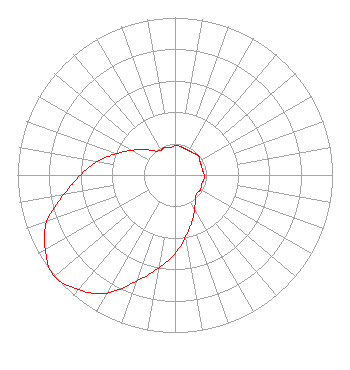 | ||||||||||||||||||
| Azimuth | Ratio | Azimuth | Ratio | Azimuth | Ratio | Azimuth | Ratio | ||||||||||||
| 0 | 0.185 | 10 | 0.185 | 20 | 0.178 | 30 | 0.178 | ||||||||||||
| 40 | 0.182 | 50 | 0.193 | 60 | 0.182 | 70 | 0.178 | ||||||||||||
| 80 | 0.178 | 90 | 0.185 | 100 | 0.185 | 110 | 0.178 | ||||||||||||
| 120 | 0.187 | 130 | 0.181 | 140 | 0.199 | 150 | 0.250 | ||||||||||||
| 160 | 0.315 | 170 | 0.396 | 180 | 0.499 | 190 | 0.600 | ||||||||||||
| 200 | 0.718 | 210 | 0.866 | 220 | 0.952 | 230 | 1.000 | ||||||||||||
| 240 | 0.952 | 250 | 0.866 | 260 | 0.718 | 270 | 0.600 | ||||||||||||
| 280 | 0.499 | 290 | 0.396 | 300 | 0.315 | 310 | 0.250 | ||||||||||||
| 320 | 0.199 | 330 | 0.181 | 340 | 0.187 | 350 | 0.178 | ||||||||||||
Structure Registration Number 1014813 Structure Type: LTOWER Registered To: American Towers LLC Structure Address: 19101 W. Grand Ave. (lindenhurst #87688) Lake Villa, IL County Name: Lake County ASR Issued: 07/15/2022 Date Built: 03/20/1963 Site Elevation: 243.8 m (800 ft.) Structure Height: 108.2 m (355 ft.) Height Overall: 117.7 m (386 ft.) Overall Height AMSL: 361.5 m (1186 ft.) FAA Determination: 07/07/2022 FAA Study #: 2021-AGL-27865-OE FAA Circular #: 70/7460-1K Paint & Light FAA Chapters: 4, 8, 12 PRIOR STUDY 2013-AGL-8174-OE 42-23-35.2 N 88-01-04.9 W (NAD 83) 42-23-35.1 N 88-01-04.6 W (Converted to NAD 27) |
5700 West Oaks Blvd. Rocklin, CA 95765 Phone: 916-251-1600 Not-for-Profit | Date: 01/03/2014 Application Certifier EDUCATIONAL MEDIA FOUNDATION 5700 West Oaks Blvd Rocklin, CA 95765 Applicant SAM WALLINGTON 5700 West Oaks Blvd Rocklin, CA 95765 VP OF ENGINEERING MARY N. O'CONNOR Wilkinson Barker Knauer, Llp | |||||||||||||||||