
FCCInfo.com
A Service of Cavell, Mertz & Associates, Inc.
(855) FCC-INFO
|
|
|
|
|
|||||||||||||||||||
|
|
WPDX-FM Channel: 285B1 104.9 MHz Clarksburg, West Virginia Service: FM - A full-service FM station or application. Facility ID: 68303 Fac. Service: FM Status: License 73.215 Station Application Accepted: 02/01/2002 Application Granted: 02/12/2002 File Number: BLH-20020201AAW License Expires: 00/00/0000 Prefix Type: This is a license for a commercial FM station Application Type: License To Cover FCC Website Links: LMS Facility Details This Application CDBS Application Other WPDX-FM Applications Other WPDX-FM Applications in CDBS Including Superseded Applications Mailing Address Correspondence for WPDX-FM Correspondence related to application BLH-20020201AAW Service Contour - Open Street Map or USGS Map (57 dBu) Service Contour - KML / Google Earth (57 dBu) Public Inspection Files History Cards for WPDX-FM Facility Type: FM STATION Class: B1, A Zone I or I-A station; with 6kW-25kW ERP and a class contour distance 28km-39km Site Location: 39-15-22.3 N 80-06-45.3 W (NAD 83) Site Location: 39-15-22.0 N 80-06-46.0 W (Converted to NAD 27) Effective Radiated Power: 7.4 kW Transmitter Output Power: 4.12 kW Antenna Center HAAT: 182 m (597 ft.) Antenna Center AMSL: 590 m (1936 ft.) Antenna Center HAG: 114 m (374 ft.) Site Elevation: 476 m. (1562 ft.) Height Overall*: 123 m (404 ft.) (* As Filed In This Application, may differ from ASR Data, Below.) Directional Antenna Antenna Make/Model: Shivley 6810-3R-DA Antenna ID: 37623 Polarization: | |||||||||||||||||||||
| Antenna Data for Antenna Id: 37623 WPDX-FM FM File: BLH-20020201AAW Shivley - 6810-3R-DA Service: FM | 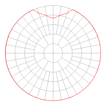 | |||||||||||||||||||||
| Azimuth | Ratio | Azimuth | Ratio | Azimuth | Ratio | Azimuth | Ratio | |||||||||||||||
| 0 | 0.733 | 5 | 0.750 | 10 | 0.794 | 15 | 0.841 | |||||||||||||||
| 20 | 0.891 | 25 | 1.000 | 30 | 1.000 | 40 | 1.000 | |||||||||||||||
| 50 | 1.000 | 60 | 1.000 | 70 | 1.000 | 80 | 1.000 | |||||||||||||||
| 90 | 1.000 | 100 | 1.000 | 110 | 1.000 | 120 | 1.000 | |||||||||||||||
| 130 | 1.000 | 140 | 1.000 | 150 | 1.000 | 160 | 1.000 | |||||||||||||||
| 170 | 1.000 | 180 | 1.000 | 190 | 1.000 | 200 | 1.000 | |||||||||||||||
| 210 | 1.000 | 220 | 1.000 | 230 | 1.000 | 240 | 1.000 | |||||||||||||||
| 250 | 1.000 | 260 | 1.000 | 270 | 1.000 | 280 | 1.000 | |||||||||||||||
| 290 | 1.000 | 300 | 1.000 | 310 | 1.000 | 320 | 1.000 | |||||||||||||||
| 330 | 1.000 | 335 | 1.000 | 340 | 0.891 | 345 | 0.841 | |||||||||||||||
| 350 | 0.794 | 355 | 0.750 | |||||||||||||||||||
Structure Registration Number 1223567 [ASR Heights Differ from WPDX-FM Application] Structure Type: GTOWER Registered To: Clearview Tower Company II, LLC Structure Address: Approx. 1 Mile Se Of Flemington, Betwen Cr 134 And Cr 135 Flemington, WV County Name: Taylor County ASR Issued: 09/01/2023 Date Built: 12/01/2001 Site Elevation: 474.1 m (1555 ft.) Structure Height: 121.8 m (400 ft.) Height Overall: 122.8 m (403 ft.) Overall Height AMSL: 596.9 m (1958 ft.) FAA Determination: 08/24/2023 FAA Study #: 2023-AEA-6957-OE FAA Circular #: 70/7460-1K Paint & Light FAA Chapters: 3, 4, 5, 12 PRIOR STUDY 2000-AEA-4214-OE 39-15-16.2 N 80-06-45.4 W (NAD 83) 39-15-15.9 N 80-06-46.1 W (Converted to NAD 27) |
P.o. Box 885 Morgantown, WV 26507 Phone: 304-292-2222 | Date: 02/01/2002 Application Certifier TSCHUDY BROADCASTING CORP. 15 Campbell Street Luray, VA 22835 Applicant PETER W. LECHMAN 9049 Shady Grove Court Gaithersburg, MD 20877 CONSULTING ENGINEER | ||||||||||||||||||||
| ||||||||||||||||||||||