
FCCInfo.com
A Service of Cavell, Mertz & Associates, Inc.
(855) FCC-INFO
|
|
|
|  |
|
|||||||||||||||||||||
|
|
WHNN Channel: 241C0 96.1 MHz Bay City, Michigan Service: FM - A full-service FM station or application. Facility ID: 37458 Fac. Service: FM Status: License Application Accepted: 02/11/1992 Application Granted: 06/12/1992 File Number: BLH-19920211KB License Expires: 10/01/1996 Prefix Type: This is a license for a commercial FM station Application Type: License To Cover FCC Website Links: LMS Facility Details This Application CDBS Application Other WHNN Applications Other WHNN Applications in CDBS Including Superseded Applications Mailing Address Correspondence for WHNN Correspondence related to application BLH-19920211KB Service Contour - Open Street Map or USGS Map (60 dBu) Service Contour - KML / Google Earth (60 dBu) Public Inspection Files History Cards for WHNN Facility Type: FM STATION Class: C0, C0 Site Location: 43-33-10.1 N 83-41-23.9 W (NAD 83) Site Location: 43-33-10.0 N 83-41-24.0 W (Converted to NAD 27) Effective Radiated Power: 100 kW Transmitter Output Power: 24 kW Antenna Center HAAT: 311 m (1020 ft.) Antenna Center AMSL: 493 m (1617 ft.) Antenna Center HAG: 315 m (1033 ft.) Site Elevation: 178 m. (584 ft.) Height Overall*: 323.3 m (1061 ft.) (* As Filed In This Application, may differ from ASR Data, Below.) Directional Antenna Antenna Make/Model: Electronics Research Inc. LP-12C-DA-SP, 12 sections Antenna ID: 14239 Polarization: | ||||||||||||||||||||||||
| Antenna Data for Antenna Id: 14239 WHNN FM File: BLH-19920211KB Electronics Research Inc. - LP-12C-DA-SP, 12 sections Service: FM | 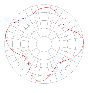 | ||||||||||||||||||||||||
| Azimuth | Ratio | Azimuth | Ratio | Azimuth | Ratio | Azimuth | Ratio | ||||||||||||||||||
| 0 | 0.916 | 6 | 0.925 | 10 | 0.916 | 20 | 0.873 | ||||||||||||||||||
| 30 | 0.793 | 40 | 0.722 | 50 | 0.688 | 60 | 0.725 | ||||||||||||||||||
| 70 | 0.865 | 80 | 0.981 | 85 | 1.000 | 90 | 0.990 | ||||||||||||||||||
| 100 | 0.947 | 110 | 0.861 | 120 | 0.758 | 130 | 0.667 | ||||||||||||||||||
| 140 | 0.625 | 150 | 0.639 | 160 | 0.701 | 170 | 0.809 | ||||||||||||||||||
| 180 | 0.915 | 187 | 0.950 | 190 | 0.944 | 200 | 0.877 | ||||||||||||||||||
| 210 | 0.736 | 220 | 0.617 | 230 | 0.560 | 240 | 0.601 | ||||||||||||||||||
| 250 | 0.708 | 260 | 0.830 | 270 | 0.913 | 280 | 0.988 | ||||||||||||||||||
| 285 | 1.000 | 290 | 0.994 | 300 | 0.958 | 310 | 0.891 | ||||||||||||||||||
| 320 | 0.831 | 330 | 0.803 | 340 | 0.811 | 350 | 0.876 | ||||||||||||||||||
Structure Registration Number 1055185 [ASR Heights Differ from WHNN Application] Structure Type: TOWER Registered To: VB Nimbus, LLC Structure Address: 9750 Dutcher Rd Guilford Twp, MI County Name: Tuscola County ASR Issued: 10/14/2020 Date Built: 01/01/1982 Site Elevation: 179 m (587 ft.) Structure Height: 322.2 m (1057 ft.) Height Overall: 323.3 m (1061 ft.) Overall Height AMSL: 502.3 m (1648 ft.) FAA Determination: 04/17/1998 FAA Study #: 98-AGL-1386-OE Paint & Light FAA Chapters: A1, B, D, H HIGH INTENSITY STROBES. 43-33-11.0 N 83-41-28.0 W (NAD 83) 43-33-10.9 N 83-41-28.1 W (Converted to NAD 27) |
780 Johnson Ferry Road Suite 500 Atlanta, GA 30342 Phone: 404-949-0700 Limited Liability Company | Date: 02/11/1992 Application Certifier LIGGETT BROADCAST, INC. Liggett Broadcast, Inc. 3420 Pine Tree Road Lansing, MI 48911 Applicant | |||||||||||||||||||||||
|
| ||||||||||||||||||||||||