
FCCInfo.com
A Service of Cavell, Mertz & Associates, Inc.
(855) FCC-INFO
|
|
|
Virtual Channel 16 |
|
|||||||||||||||||||
|
|
Status: STA – Special Temporary Authority Application Accepted: 09/12/2016 STA Expires: 09/28/2016 File Number: -0000013985 FCC Website Links: LMS Facility Details This Application Other KMRZ-LD Applications Including Superseded Applications Mailing Address Correspondence for KMRZ-LD Correspondence related to application -0000013985 Service Contour - Open Street Map or USGS Map (51 dBu) Service Contour - KML / Google Earth (51 dBu) Rabbit Ears Info Search for KMRZ-LD Site Location: 34-13-55.0 N 118-04-21.0 W (NAD 83) Site Location: 34-13-55.0 N 118-04-17.8 W (Converted to NAD 27) ERP: 8 kW R/C AGL: 72 m (236 ft.) R/C AMSL: 1796.7 m (5895 ft.) Emission Mask: Stringent Site Elevation: 1724.7 m. (5658 ft.) Height Overall*: 296.4 m (972 ft.) (* As Filed In This Application, may differ from ASR Data, Below.) Directional Antenna - Antenna Make/Model: SBP UPC-4 Antenna ID: 110097
| |||||||||||||||||||||
| Antenna Data for Antenna Id: 110097 KMRZ-LD LD File: -0000013985 SBP - UPC-4 Service: LD Standard Pattern: Y Pattern and Field Values Include a 140° Clockwise Rotation | 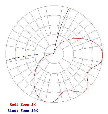 | |||||||||||||||||||||
| Azimuth | Ratio | Azimuth | Ratio | Azimuth | Ratio | Azimuth | Ratio | |||||||||||||||
| 0 | 0.001 | 10 | 0.024 | 20 | 0.120 | 30 | 0.237 | |||||||||||||||
| 40 | 0.348 | 50 | 0.485 | 60 | 0.636 | 70 | 0.803 | |||||||||||||||
| 80 | 0.939 | 90 | 1.000 | 100 | 0.977 | 110 | 0.839 | |||||||||||||||
| 120 | 0.789 | 130 | 0.895 | 140 | 0.999 | 150 | 0.895 | |||||||||||||||
| 160 | 0.789 | 170 | 0.839 | 180 | 0.977 | 190 | 1.000 | |||||||||||||||
| 200 | 0.939 | 210 | 0.803 | 220 | 0.636 | 230 | 0.485 | |||||||||||||||
| 240 | 0.348 | 250 | 0.237 | 260 | 0.120 | 270 | 0.024 | |||||||||||||||
| 280 | 0.001 | 290 | 0.001 | 300 | 0.001 | 310 | 0.001 | |||||||||||||||
| 320 | 0.001 | 330 | 0.001 | 340 | 0.001 | 350 | 0.001 | |||||||||||||||
Structure Registration Number 1012836 Structure Type: GTOWER Registered To: American Towers LLC Structure Address: 123 Cbs Lane Mount Wilson, CA County Name: Los Angeles County ASR Issued: 05/17/2017 Date Built: 01/01/1986 Site Elevation: 1724.7 m (5658 ft.) Structure Height: 274.2 m (900 ft.) Height Overall: 296.4 m (972 ft.) Overall Height AMSL: 2021.1 m (6631 ft.) FAA Determination: 06/05/1997 FAA Study #: 97-AWP-1265-OE Paint & Light FAA Chapters: 1, 3, 6, 15, 21 RED LIGHTS/PAINT - SPEC. COND: PARAGRAPH 6 MODIFIED TO REQUIRE LIGHTS AT THE TWO-THIRDS LEVEL ONLY. PARAGRAPHS 15 MODIFIED TO REQUIRE LIGHTS AT THE FIVE-SIXTHS LEVEL ONLY. SHIELDING MUST BE PLACED ON LIGHT UNDERSIDE TO AVOID INTERFERENCE TO OBSERVATORY 34-13-55.0 N 118-04-21.0 W (NAD 83) 34-13-55.0 N 118-04-17.8 W (Converted to NAD 27) |
150 S Arroyo Pkwy #103 Pasadena, CA 91105 Phone: 323-965-5400 Limited Liability Company | Title: Manager Date: 09/12/2016 Application Certifier Venture Technologies Group, Llc 5670 Wilshire Blvd., Suite 1300 Los Angeles, CA 90036 Applicant LAWRENCE ROGOW Venture Technologies Group, Llc 5670 Wilshire Blvd. Suite 1300 Los Angeles, CA 90036 MANAGER JOAN STEWART Wiley Rein Llp 1776 K Street Nw Washington, DC 20006 | ||||||||||||||||||||