
FCCInfo.com
A Service of Cavell, Mertz & Associates, Inc.
(855) FCC-INFO
|
|
W45DN-D from 08/18/2009 W45DN-D from 04/10/2006 |
|
|
||||||||||||||||
|
|
Status: License Application Accepted: 02/01/2011 License Expires: 10/01/2020 File Number: BLDTL-20110201ACL Prefix Type: This is BLDTL FCC Website Links: LMS Facility Details This Application Other W45DN-D Applications Including Superseded Applications Mailing Address Correspondence for W45DN-D Correspondence related to application BLDTL-20110201ACL Service Contour - Open Street Map or USGS Map (51 dBu) Service Contour - KML / Google Earth (51 dBu) Rabbit Ears Info Search for W45DN-D Site Location: 38-54-31.9 N 76-34-27.9 W (NAD 83) Site Location: 38-54-31.5 N 76-34-29.0 W (Converted to NAD 27) ERP: 15 kW R/C AGL: 107 m (351 ft.) R/C AMSL: 140.5 m (461 ft.) Emission Mask: Stringent Site Elevation: 33.5 m. (110 ft.) Height Overall*: 160 m (525 ft.) (* As Filed In This Application, may differ from ASR Data, Below.) Directional Antenna - Antenna Make/Model: MICRO COMMUNICATIONS INC 955314 Antenna ID: 20059 | ||||||||||||||||||
| Antenna Data for Antenna Id: 20059 W45DN-D LD File: BLDTL-20110201ACL MICRO COMMUNICATIONS INC - 955314 Service: LD Standard Pattern: Y Pattern and Field Values Include a 250° Clockwise Rotation | 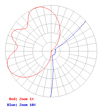 | ||||||||||||||||||
| Azimuth | Ratio | Azimuth | Ratio | Azimuth | Ratio | Azimuth | Ratio | ||||||||||||
| 0 | 0.872 | 10 | 0.729 | 20 | 0.556 | 30 | 0.378 | ||||||||||||
| 40 | 0.218 | 50 | 0.094 | 60 | 0.021 | 70 | 0.010 | ||||||||||||
| 80 | 0.010 | 90 | 0.010 | 100 | 0.010 | 110 | 0.010 | ||||||||||||
| 120 | 0.010 | 130 | 0.010 | 140 | 0.010 | 150 | 0.010 | ||||||||||||
| 160 | 0.010 | 170 | 0.021 | 180 | 0.094 | 190 | 0.218 | ||||||||||||
| 200 | 0.378 | 210 | 0.556 | 220 | 0.729 | 230 | 0.872 | ||||||||||||
| 240 | 0.967 | 250 | 1.000 | 260 | 0.947 | 270 | 0.793 | ||||||||||||
| 275 | 0.740 | 280 | 0.756 | 290 | 0.902 | 295 | 0.933 | ||||||||||||
| 300 | 0.902 | 310 | 0.756 | 315 | 0.740 | 320 | 0.793 | ||||||||||||
| 330 | 0.947 | 340 | 1.000 | 350 | 0.967 | ||||||||||||||
Structure Registration Number 1035820 Structure Type: 2TOWER Registered To: Pinnacle Towers LLC Structure Address: 118a S River Clubhouse Road Harwood, MD County Name: Anne Arundel County ASR Issued: 05/06/2016 Date Built: 04/24/1997 Site Elevation: 33.5 m (110 ft.) Structure Height: 152.4 m (500 ft.) Height Overall: 160 m (525 ft.) Overall Height AMSL: 193.5 m (635 ft.) FAA Determination: 09/02/2011 FAA Study #: 2011-AEA-2232-OE FAA Circular #: 70/7460-1J Paint & Light FAA Chapters: 3, 4, 5, 13 PRIOR STUDY 2009-AEA-1743-OE 38-54-31.9 N 76-34-27.9 W (NAD 83) 38-54-31.5 N 76-34-29.0 W (Converted to NAD 27) |
Hurst, TX 76054 Phone: 214-770-7770 Corporation | Date: 02/01/2011 Application Certifier EICB-TV EAST, LLC 406 Copeland Drive Cedar Hill, TX 75104 Applicant B. W. ST. CLAIR 2355 Ranch Drive Westminster, CO 80234 ENGINEERING CONSULTANT DR. RANDY WEISS Eicb-tv East, Llc | |||||||||||||||||