
FCCInfo.com
A Service of Cavell, Mertz & Associates, Inc.
(855) FCC-INFO
|
|
KJMT from 03/03/2005 |
|  |
|
|||||||||||||||
|
|
KJMT Channel: 246C3 97.1 MHz Calico Rock, Arkansas Service: FM - A full-service FM station or application. Facility ID: 162375 Fac. Service: FM Status: License (Licensed And Silent) 73.215 Station Application Accepted: 03/16/2007 Application Granted: 03/29/2007 File Number: BLH-20070316ABY License Expires: 00/00/0000 Prefix Type: This is a license for a commercial FM station Application Type: License To Cover FCC Website Links: LMS Facility Details This Application CDBS Application Other KJMT Applications Other KJMT Applications in CDBS Including Superseded Applications Mailing Address Correspondence for KJMT Correspondence related to application BLH-20070316ABY Service Contour - Open Street Map or USGS Map (60 dBu) Service Contour - KML / Google Earth (60 dBu) Public Inspection Files Facility Type: FM STATION Class: C3, A Zone II station; with 6kW-25kW ERP and a class contour distance 28km-39km Site Location: 36-05-31.3 N 92-15-46.6 W (NAD 83) Site Location: 36-05-31.0 N 92-15-46.0 W (Converted to NAD 27) Effective Radiated Power: 5.2 kW Transmitter Output Power: 3.518 kW Antenna Center HAAT: 218 m (715 ft.) Antenna Center AMSL: 454.4 m (1491 ft.) Antenna Center HAG: 100.8 m (331 ft.) Calculated Site Elevation: 353.6 m. (1160 ft.) Height Overall*: 106.4 m (349 ft.) (* As Filed In This Application, may differ from ASR Data, Below.) Directional Antenna Antenna Make/Model: Shivley 6810-2R-DA Antenna ID: 70757 Polarization: | ||||||||||||||||||
| Antenna Data for Antenna Id: 70757 KJMT FM File: BLH-20070316ABY Shivley - 6810-2R-DA Service: FM | 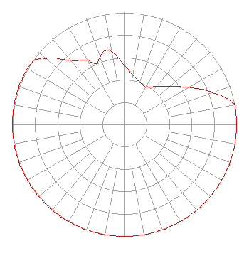 | ||||||||||||||||||
| Azimuth | Ratio | Azimuth | Ratio | Azimuth | Ratio | Azimuth | Ratio | ||||||||||||
| 0 | 0.526 | 10 | 0.443 | 20 | 0.402 | 30 | 0.385 | ||||||||||||
| 40 | 0.441 | 50 | 0.526 | 60 | 0.662 | 70 | 0.834 | ||||||||||||
| 79 | 0.987 | 80 | 1.000 | 90 | 1.000 | 100 | 1.000 | ||||||||||||
| 110 | 1.000 | 120 | 1.000 | 130 | 1.000 | 140 | 1.000 | ||||||||||||
| 150 | 1.000 | 160 | 1.000 | 170 | 1.000 | 180 | 1.000 | ||||||||||||
| 190 | 1.000 | 200 | 1.000 | 210 | 1.000 | 220 | 1.000 | ||||||||||||
| 230 | 1.000 | 240 | 1.000 | 250 | 1.000 | 260 | 1.000 | ||||||||||||
| 270 | 1.000 | 280 | 1.000 | 290 | 1.000 | 300 | 1.000 | ||||||||||||
| 306 | 0.983 | 310 | 0.915 | 320 | 0.746 | 330 | 0.665 | ||||||||||||
| 335 | 0.597 | 340 | 0.640 | 345 | 0.680 | 350 | 0.659 | ||||||||||||
Structure Registration Number 1250397 Structure Type: GTOWER Registered To: VB-S1 Assets, LLC Structure Address: 4207 Cr 74 / Us-ar-5023 Calico Rock, AR County Name: Baxter County ASR Issued: 12/07/2020 Date Built: 08/21/2006 Site Elevation: 353.6 m (1160 ft.) Structure Height: 105.2 m (345 ft.) Height Overall: 106.4 m (349 ft.) Overall Height AMSL: 460 m (1509 ft.) FAA Determination: 05/27/2020 FAA Study #: 2020-ASW-7083-OE FAA Circular #: 70/7460-1L Paint & Light FAA Chapters: 4, 8, 12 PRIOR STUDY 2005-ASW-2891-OE 36-05-31.5 N 92-15-47.0 W (NAD 83) 36-05-31.2 N 92-15-46.4 W (Converted to NAD 27) |
3218 Quincy Street Plainview, TX 79073 Phone: 806-777-8542 Limited Liability Company | Date: 03/16/2007 Application Certifier MALVERN ENTERTAINMENT CORPORATION 204 Boulder Ridge Circle Texarkana, AR 71854 Applicant SCOTT A, GRAY 204 Boulder Ridge Circle Texarkana, AR 71854 APPLICANT PRINCIPAL SCOTT A. GRAY Gray Media Corporation | |||||||||||||||||
| |||||||||||||||||||