
FCCInfo.com
A Service of Cavell, Mertz & Associates, Inc.
(855) FCC-INFO
|
|
K295CH from 09/29/2011 K295CH from 08/16/2011 K295CH from 06/21/2011 K295CH from 10/13/1994 |
|
|
||||||||||||||||
|
|
K295CH Channel: 295D 106.9 MHz Kansas City, Kansas Service: FX - A translator or application for a translator. Facility ID: 36259 Fac. Service: FX Programming Delivery Method: Unspecified Status: License Application Accepted: 05/21/2018 Application Granted: 05/24/2018 File Number: BLFT-20180521AAS License Expires: 06/01/2029 Prefix Type: This is a license for a translator Application Type: License To Cover FCC Website Links: LMS Facility Details This Application CDBS Application Other K295CH Applications Other K295CH Applications in CDBS Including Superseded Applications Mailing Address Correspondence for K295CH Correspondence related to application BLFT-20180521AAS Service Contour - Open Street Map or USGS Map (60 dBu) Service Contour - KML / Google Earth (60 dBu) Class: D, A Noncommercial educational operating with no more than 10W Site Location: 39-00-56.0 N 94-30-24.8 W (NAD 83) Site Location: 39-00-56.0 N 94-30-24.0 W (Converted to NAD 27) Effective Radiated Power: 0.115 kW Transmitter Output Power: 0.46 kW Antenna Center HAAT: 0 m Antenna Center AMSL: 550 m (1804 ft.) Antenna Center HAG: 279 m (915 ft.) Site Elevation: 271 m. (889 ft.) Height Overall*: 336 m (1102 ft.) (* As Filed In This Application, may differ from ASR Data, Below.) Directional Antenna Antenna Make/Model: NIC BKG77 Antenna ID: 127507 Polarization: H
| ||||||||||||||||||
| Antenna Data for Antenna Id: 127507 K295CH FX File: BLFT-20180521AAS NIC - BKG77 Service: FX Pattern and Field Values Include a 100° Clockwise Rotation | 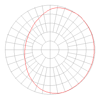 | ||||||||||||||||||
| Azimuth | Ratio | Azimuth | Ratio | Azimuth | Ratio | Azimuth | Ratio | ||||||||||||
| 0 | 0.897 | 10 | 0.953 | 20 | 0.973 | 30 | 0.983 | ||||||||||||
| 40 | 1.000 | 50 | 0.992 | 60 | 0.988 | 70 | 0.988 | ||||||||||||
| 80 | 0.983 | 90 | 0.983 | 100 | 0.983 | 110 | 0.983 | ||||||||||||
| 120 | 0.983 | 130 | 0.988 | 140 | 0.988 | 150 | 0.992 | ||||||||||||
| 160 | 1.000 | 170 | 0.991 | 180 | 0.963 | 190 | 0.923 | ||||||||||||
| 200 | 0.862 | 210 | 0.797 | 220 | 0.731 | 230 | 0.676 | ||||||||||||
| 240 | 0.628 | 250 | 0.594 | 260 | 0.571 | 270 | 0.558 | ||||||||||||
| 280 | 0.553 | 290 | 0.558 | 300 | 0.571 | 310 | 0.594 | ||||||||||||
| 320 | 0.628 | 330 | 0.682 | 340 | 0.738 | 350 | 0.815 | ||||||||||||
Structure Registration Number 1003006 Structure Type: TOWER Registered To: American Towers LLC Structure Address: Kmxv 6621 E 58th St ( Kansas City Kmxv #3201) Kansas City, MO County Name: Jackson County ASR Issued: 01/15/2013 Date Built: 02/08/1987 Site Elevation: 271.3 m (890 ft.) Structure Height: 334.7 m (1098 ft.) Height Overall: 335.9 m (1102 ft.) Overall Height AMSL: 607.2 m (1992 ft.) FAA Determination: 09/09/2009 FAA Study #: 2009-ACE-1492-OE FAA Circular #: 70/7460-1G Paint & Light FAA Chapters: 3, 4, 5, 9 PRIOR STUDY 2009-ACE-1202-OE 39-00-56.5 N 94-30-25.0 W (NAD 83) 39-00-56.5 N 94-30-24.2 W (Converted to NAD 27) |
11131 Colorado Ave Kansas City, MO 64137 Phone: 816-763-2040 Corporation | Date: 05/21/2018 Application Certifier ALPINE BROADCASTING CORPORATION 310 S. La Frenz Road Liberty, MO 64068 Applicant GENE WISNIEWSKI 160 Gooding Street West Suite A Twin Falls, ID 83301 TECHNICAL CONSULTANT MATTHEW H. MCCORMICK, ESQUIRE Fletcher, Heald & Hildreth, Plc 1300 North 17th Street 11th Floor Arlington, VA 22209 | |||||||||||||||||