
FCCInfo.com
A Service of Cavell, Mertz & Associates, Inc.
(855) FCC-INFO
|
|
K214FJ from 03/04/2020 K214FJ from 03/02/2017 K214FJ from 10/23/2013 |
|
|
||||||||||||||||
|
|
K214FJ Channel: 214D 90.7 MHz Golden, Colorado Service: FX - A translator or application for a translator. Facility ID: 147935 Fac. Service: FX Programming Delivery Method: Unspecified Status: License Application Accepted: 02/24/2020 Application Granted: 03/04/2020 File Number: -0000106518 License Expires: 04/01/2021 Application Type: License To Cover FCC Website Links: LMS Facility Details This Application Other K214FJ Applications Other K214FJ Applications in CDBS Including Superseded Applications Mailing Address Correspondence for K214FJ Correspondence related to application -0000106518 Service Contour - Open Street Map or USGS Map (60 dBu) Service Contour - KML / Google Earth (60 dBu) Facility Type: NON-COMMERCIAL EDUC. FM Class: D, A Noncommercial educational operating with no more than 10W Site Location: 39-47-05.0 N 105-12-58.0 W (NAD 83) Site Location: 39-47-05.0 N 105-12-56.0 W (Converted to NAD 27) Effective Radiated Power: 0.023 kW Antenna Center HAAT: 0 m Antenna Center AMSL: 2016 m (6614 ft.) Antenna Center HAG: 29.3 m (96 ft.) Site Elevation: 1986.7 m. (6518 ft.) Height Overall*: 35.1 m (115 ft.) (* As Filed In This Application, may differ from ASR Data, Below.) Directional Antenna Antenna Make/Model: SCALA CA2-CP Antenna ID: 134320 Polarization: H
| ||||||||||||||||||
| Antenna Data for Antenna Id: 134320 K214FJ FX File: -0000106518 SCALA - CA2-CP Service: FX | 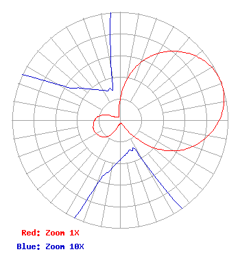 | ||||||||||||||||||
| Azimuth | Ratio | Azimuth | Ratio | Azimuth | Ratio | Azimuth | Ratio | ||||||||||||
| 0 | 0.187 | 10 | 0.388 | 20 | 0.570 | 30 | 0.715 | ||||||||||||
| 40 | 0.829 | 50 | 0.920 | 60 | 0.979 | 70 | 1.000 | ||||||||||||
| 80 | 0.979 | 90 | 0.920 | 100 | 0.829 | 110 | 0.715 | ||||||||||||
| 120 | 0.570 | 130 | 0.388 | 140 | 0.187 | 150 | 0.045 | ||||||||||||
| 160 | 0.030 | 170 | 0.032 | 180 | 0.037 | 190 | 0.046 | ||||||||||||
| 200 | 0.065 | 210 | 0.142 | 220 | 0.202 | 230 | 0.234 | ||||||||||||
| 240 | 0.250 | 250 | 0.260 | 260 | 0.250 | 270 | 0.234 | ||||||||||||
| 280 | 0.202 | 290 | 0.142 | 300 | 0.065 | 310 | 0.046 | ||||||||||||
| 320 | 0.037 | 330 | 0.032 | 340 | 0.030 | 350 | 0.045 | ||||||||||||
Structure Registration Number 1060784 Structure Type: Registered To: DMR Networks Structure Address: North Table Mountain, 4800 State Highway 93 Golden, CO County Name: Jefferson County ASR Issued: 06/29/2017 Date Built: 04/01/1964 Site Elevation: 1986.7 m (6518 ft.) Structure Height: 29 m (95 ft.) Height Overall: 35.1 m (115 ft.) Overall Height AMSL: 2021.8 m (6633 ft.) Paint & Light FAA Chapters: None 39-47-05.0 N 105-12-58.0 W (NAD 83) 39-47-05.0 N 105-12-56.0 W (Converted to NAD 27) |
87 Jasper Lake Road Loveland, CO 80537 Phone: 970-669-9200 Not-for-Profit | Title: President Date: 02/24/2020 Application Certifier CEDAR COVE BROADCASTING, INC. Cedar Cove Broadcasting, Inc. 87 Jasper Lake Road Loveland, CO 80537 Applicant Victor A Michael, Jr. Cedar Cove Broadcasting, Inc. 87 Jasper Lake Road Loveland, CO 80537 President/Director Victor A Michael, Jr. Cedar Cove Broadcasting, Inc. 87 Jasper Lake Road Loveland, CO 80537 Technical Consultant | |||||||||||||||||