
FCCInfo.com
A Service of Cavell, Mertz & Associates, Inc.
(855) FCC-INFO
|
|
|
|
|
||||||||||||||||
|
|
Channel: 217A 91.3 MHz Shark River Hills, New Jersey Service: FM - A full-service FM station or application. Facility ID: 768139 Fac. Service: FM Status: Construction Permit Application Accepted: 11/09/2021 Application Granted: 01/07/2022 File Number: -0000167413 CP Expires: 01/07/2025 Application Type: Non-Commercial Educational New NCE FM CP FCC Website Links: LMS Facility Details This Application Other Applications Other Applications in CDBS Including Superseded Applications Mailing Address Correspondence for Correspondence related to application -0000167413 Service Contour - Open Street Map or USGS Map (60 dBu) Service Contour - KML / Google Earth (60 dBu) Facility Type: NON-COMMERCIAL EDUC. FM Class: A, A Zone I; I-A; or II station; with 0.1kW-6kW ERP and a class contour distance <=28km Site Location: 40-13-38.8 N 74-12-22.8 W (NAD 83) Site Location: 40-13-38.4 N 74-12-24.3 W (Converted to NAD 27) Effective Radiated Power: 0 kW Horiz. ; 0.6 kW Vert. Antenna Center HAAT: 0 m Horiz.; 78 m Vert. Antenna Center AMSL: 0 m Horiz.; 117 m Vert. Antenna Center HAG: 0 m Horiz.; 85 m Vert. Site Elevation: 31.7 m. (104 ft.) Height Overall*: 103.3 m (339 ft.) (* As Filed In This Application, may differ from ASR Data, Below.) Directional Antenna Antenna Make/Model: None Antenna ID: 69-2019-08-06 Polarization: | ||||||||||||||||||
| Antenna Data for Antenna Id: 69-2019-08-06 FM File: -0000167413 None - Service: FM | 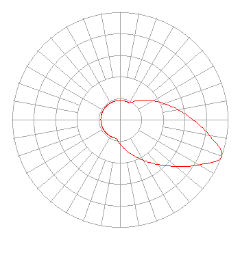 | ||||||||||||||||||
| Azimuth | Ratio | Azimuth | Ratio | Azimuth | Ratio | Azimuth | Ratio | ||||||||||||
| 0 | 0.178 | 10 | 0.178 | 20 | 0.178 | 30 | 0.182 | ||||||||||||
| 40 | 0.226 | 50 | 0.282 | 60 | 0.351 | 70 | 0.436 | ||||||||||||
| 80 | 0.543 | 90 | 0.676 | 100 | 0.841 | 110 | 1.000 | ||||||||||||
| 120 | 0.841 | 130 | 0.676 | 140 | 0.543 | 150 | 0.436 | ||||||||||||
| 160 | 0.351 | 170 | 0.282 | 180 | 0.226 | 190 | 0.182 | ||||||||||||
| 200 | 0.178 | 210 | 0.178 | 220 | 0.178 | 230 | 0.178 | ||||||||||||
| 240 | 0.178 | 250 | 0.178 | 260 | 0.178 | 270 | 0.178 | ||||||||||||
| 280 | 0.178 | 290 | 0.178 | 300 | 0.178 | 310 | 0.178 | ||||||||||||
| 320 | 0.178 | 330 | 0.178 | 340 | 0.178 | 350 | 0.178 | ||||||||||||
Structure Registration Number 1061894 Structure Type: LTOWER Registered To: SBA Structures, LLC Structure Address: 1014 Route 33 (nj20027-a) Freehold, NJ County Name: Monmouth County ASR Issued: 07/03/2023 Date Built: 03/02/1999 Site Elevation: 31.7 m (104 ft.) Structure Height: 100 m (328 ft.) Height Overall: 103.3 m (339 ft.) Overall Height AMSL: 135 m (443 ft.) FAA Determination: 01/13/2023 FAA Study #: 2022-AEA-1398-OE FAA Circular #: 70/7460-1K Paint & Light FAA Chapters: 4, 8, 12 PRIOR STUDY 2005-AEA-1425-OE 40-13-38.8 N 74-12-22.8 W (NAD 83) 40-13-38.4 N 74-12-24.3 W (Converted to NAD 27) |
2100 W, 76th St. #304 Hialeah, FL 33016 Phone: 786-656-9130 Not-for-Profit | Title: President Date: 11/09/2021 Application Certifier World Federation Of Pastors And Ministers Of The Full Gospel, Inc. 2100 W, 76th St. #304 Hialeah, FL 33016 Applicant Darryl K DeLawder Delawder Communications, Inc. P.o. Box 1095 Ashburn, VA 20146-1095 President Dan J Alpert The Law Office Of Dan J. Alpert 2120 21st Rd. N Arlington, VA 22201 Legal Counsel | |||||||||||||||||