
FCCInfo.com
A Service of Cavell, Mertz & Associates, Inc.
(855) FCC-INFO
|
|
WSKQ-FM from 11/03/1981 WSKQ-FM from 08/11/1980 |
|  |
|
|||||||||||||||
|
|
WSKQ-FM Channel: 250B 97.9 MHz New York, New York Service: FS - A full service FM station auxiliary transmitting antenna or application. Facility ID: 61641 Fac. Service: FM Status: Construction Permit Application Accepted: 12/14/2022 Application Granted: 01/24/2023 File Number: -0000205132 WSKQ-FM CP Expires: 01/24/2026 Application Type: Construction Permit FCC Website Links: LMS Facility Details This Application Other WSKQ-FM Applications Other WSKQ-FM Applications in CDBS Including Superseded Applications Mailing Address Correspondence for WSKQ-FM Correspondence related to application -0000205132 Service Contour - Open Street Map or USGS Map (54 dBu) Service Contour - KML / Google Earth (54 dBu) Public Inspection Files History Cards for WSKQ-FM Facility Type: FM STATION Class: B, A Zone I or I-A station; with 25kW-50kW ERP and a class contour distance 39km-52km Site Location: 40-57-39.0 N 73-55-21.0 W (NAD 83) Site Location: 40-57-38.6 N 73-55-22.5 W (Converted to NAD 27) Effective Radiated Power: 20 kW Antenna Center HAAT: 231 m (758 ft.) Antenna Center AMSL: 271.5 m (891 ft.) Antenna Center HAG: 113 m (371 ft.) Site Elevation: 158.5 m. (520 ft.) Height Overall*: 129.6 m (425 ft.) (* As Filed In This Application, may differ from ASR Data, Below.) Directional Antenna Antenna Make/Model: None Antenna ID: 69-2019-08-06 Polarization: | ||||||||||||||||||
| Antenna Data for Antenna Id: 69-2019-08-06 WSKQ-FM FS File: -0000205132 None - Service: FS | 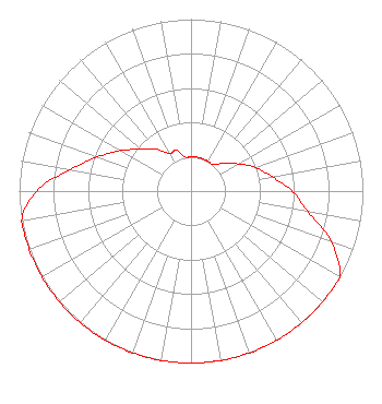 | ||||||||||||||||||
| Azimuth | Ratio | Azimuth | Ratio | Azimuth | Ratio | Azimuth | Ratio | ||||||||||||
| 0 | 0.200 | 10 | 0.200 | 20 | 0.200 | 30 | 0.200 | ||||||||||||
| 40 | 0.200 | 50 | 0.252 | 60 | 0.317 | 70 | 0.399 | ||||||||||||
| 80 | 0.480 | 90 | 0.590 | 100 | 0.690 | 110 | 0.869 | ||||||||||||
| 120 | 1.000 | 130 | 1.000 | 140 | 1.000 | 150 | 1.000 | ||||||||||||
| 160 | 1.000 | 170 | 1.000 | 180 | 1.000 | 190 | 1.000 | ||||||||||||
| 200 | 1.000 | 210 | 1.000 | 220 | 1.000 | 230 | 1.000 | ||||||||||||
| 240 | 1.000 | 250 | 1.000 | 260 | 1.000 | 270 | 0.900 | ||||||||||||
| 280 | 0.715 | 290 | 0.580 | 300 | 0.470 | 310 | 0.380 | ||||||||||||
| 320 | 0.317 | 330 | 0.252 | 340 | 0.252 | 350 | 0.200 | ||||||||||||
Structure Registration Number 1048672 Structure Type: TOWER Registered To: K2 Towers II, LLC Structure Address: Us Rt 9w Alpine, NJ County Name: Bergen County ASR Issued: 12/24/2019 Date Built: 05/22/2003 Site Elevation: 158.5 m (520 ft.) Structure Height: 121.9 m (400 ft.) Height Overall: 129.6 m (425 ft.) Overall Height AMSL: 288.1 m (945 ft.) FAA Determination: 06/03/2003 FAA Study #: 2001-AEA-3702-OE FAA Circular #: 70/7460-1K Paint & Light FAA Chapters: 3, 4, 5, 12 PRIOR STUDY 73-AEA-1004-OE 40-57-39.0 N 73-55-21.0 W (NAD 83) 40-57-38.6 N 73-55-22.5 W (Converted to NAD 27) |
7007 Nw 77th Ave. Miami, FL 33166 Phone: 305-441-6901 Corporation | Title: Secretary Date: 12/14/2022 Application Certifier WSKQ LICENSING, INC. Wskq Licensing, Inc. 7007 Nw 77th Ave. Miami, FL 33166 Applicant Nancy A. Ory Lerman Senter Pllc 2001 L Street, Nw, Suite 400 Washington, DC 20036 Attorney William J Getz Carl T. Jones Corporation 7901 Yarnwood Ct. Springfield, VA 22153 Consulting Engineer | |||||||||||||||||